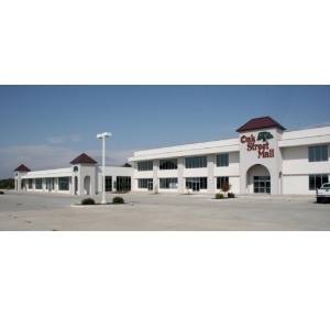
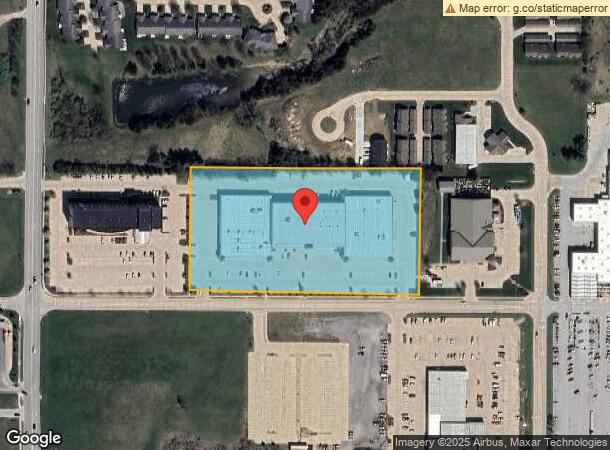
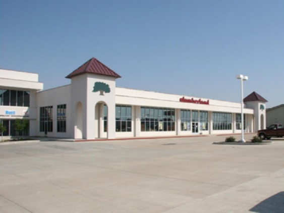
Property Record
4917 Oak St, Quincy, IL 62305

NEARBY LISTINGS FOR SALE OR LEASE
Property Detail
4917 Oak St
Quincy, IL-MO
Brink Bus Park
23-7-0698-015-00
LOT 3 BRINK BUSINESS PARK LOTS 2 & 3
Commercialnec
Adams
X
Illinois
17001C0329D
3,2
2023
5.90 AC
2023
Effingham/Central Illinois Area
000100
Other Market Areas
DEMOGRAPHICS near 4917 Oak St
1 Mile
3 Mile
5 Mile
2024 Total Population
2,019
23,966
50,352
2029 Population
1,977
23,596
49,827
Pop Growth 2024-2029
(2.08%)
(1.54%)
(1.04%)
Average Age
48
42
42
2024 Total Households
974
10,110
21,282
HH Growth 2024-2029
(2.05%)
(1.64%)
(1.13%)
Median Household Inc
$55,445
$66,773
$56,956
Avg Household Size
2.00
2.30
2.20
2024 Avg HH Vehicles
2.00
2.00
2.00
Median Home Value
$169,775
$162,307
$149,676
Median Year Built
1980
1965
1963
Nearby Places
- Restaurants
- Banks
- Shops
- Fitness
- Groceries
PUBLIC TRANSPORTATION
COMMUTER RAIL
Quincy Amtrak Station (Carl Sandburg - Amtrak, Illinois Zephyr - Amtrak)
DRIVE
WALK
Distance
Quincy Amtrak Station (Carl Sandburg - Amtrak, Illinois Zephyr - Amtrak)
8 min
3.4 mi
Freight Ports
Port Milwaukee
DRIVE
WALK
Distance
Port Milwaukee
402 min
350.6 mi
Nearby Properties
Address
Land Use
TOTAL SIZE
Lot Size
Zoning
Address
Land Use
TOTAL SIZE
Lot Size
Zoning
39.60 AC
Address
Land Use
TOTAL SIZE
Lot Size
Zoning
0.49 AC
Address
Land Use
TOTAL SIZE
Lot Size
Zoning
Address
Land Use
TOTAL SIZE
Lot Size
Zoning
21.30 AC
Address
Land Use
TOTAL SIZE
Lot Size
Zoning
1.65 AC
Address
Land Use
TOTAL SIZE
Lot Size
Zoning
19.49 AC
Address
Land Use
TOTAL SIZE
Lot Size
Zoning
19.52 AC
Address
Land Use
TOTAL SIZE
Lot Size
Zoning
30.48 AC
Address
Land Use
TOTAL SIZE
Lot Size
Zoning
41.26 AC
Address
Land Use
TOTAL SIZE
Lot Size
Zoning
32.12 AC
Address
Land Use
TOTAL SIZE
Lot Size
Zoning
7.35 AC
Address
Land Use
TOTAL SIZE
Lot Size
Zoning
8.74 AC
Address
Land Use
TOTAL SIZE
Lot Size
Zoning
Address
Land Use
TOTAL SIZE
Lot Size
Zoning
12.87 AC
Address
Land Use
TOTAL SIZE
Lot Size
Zoning
20.17 AC
Address
Land Use
TOTAL SIZE
Lot Size
Zoning
9.67 AC
Address
Land Use
TOTAL SIZE
Lot Size
Zoning
3.60 AC
Address
Land Use
TOTAL SIZE
Lot Size
Zoning
6.16 AC
Address
Land Use
TOTAL SIZE
Lot Size
Zoning
7.04 AC
Address
Land Use
TOTAL SIZE
Lot Size
Zoning
11.17 AC
Address
Land Use
TOTAL SIZE
Lot Size
Zoning
7.51 AC
Address
Land Use
TOTAL SIZE
Lot Size
Zoning
9.09 AC
Address
Land Use
TOTAL SIZE
Lot Size
Zoning
21.03 AC
Address
Land Use
TOTAL SIZE
Lot Size
Zoning
9.67 AC
Address
Land Use
TOTAL SIZE
Lot Size
Zoning
17.30 AC
Address
Land Use
TOTAL SIZE
Lot Size
Zoning
11.40 AC
Address
Land Use
TOTAL SIZE
Lot Size
Zoning
65.13 AC
Address
Land Use
TOTAL SIZE
Lot Size
Zoning
39.97 AC
Address
Land Use
TOTAL SIZE
Lot Size
Zoning
23.52 AC
Address
Land Use
TOTAL SIZE
Lot Size
Zoning
5.31 AC
The World's #1 Commercial Real Estate Marketplace
Connect with us
© 2025 CoStar Group
The information above has been obtained from sources believed reliable. While we do not doubt its accuracy we have not verified it and make no guarantee, warranty or representation about it. It is your responsibility to independently confirm its accuracy and completeness. Any projections, opinions, assumptions, or estimates used are for example only and do not represent the current or future performance of the property. The value of this transaction to you depends on tax and other factors which should be evaluated by your tax, financial, and legal advisors. You and your advisors should conduct a careful, independent investigation of the property to determine to your satisfaction the suitability of the property for your needs.