Property Record
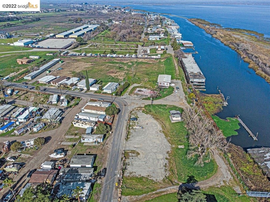
4942 N Stone Rd, Bethel Island, CA 94511


NEARBY LISTINGS FOR SALE OR LEASE
-
-
View all Bethel Island listings for sale on LoopNet.com
Property Detail
4942 N Stone Rd
Oakland-Hayward-Berkeley, CA
Pleasantimes Sub
030-050-019-6
PLEASANTIMES SUBN LOTS 142 TO 148 INCL
Portharbor
Contra Costa
AE
California
06077C0265F
142
2023
1.29 AC
2024
Antioch/Pittsburg
301000
East Bay/Oakland
384 SF
DEMOGRAPHICS near 4942 N Stone Rd
1 Mile
3 Mile
5 Mile
2024 Total Population
337
4,867
11,864
2029 Population
315
4,750
11,701
Pop Growth 2024-2029
(6.53%)
(2.40%)
(1.37%)
Average Age
49
40
37
2024 Total Households
155
1,759
3,703
HH Growth 2024-2029
(7.10%)
(2.90%)
(1.76%)
Median Household Inc
$89,732
$104,885
$118,462
Avg Household Size
2.10
2.70
3.20
2024 Avg HH Vehicles
2.00
2.00
3.00
Median Home Value
$560,484
$601,282
$684,732
Median Year Built
1974
1979
2001
Nearby Places
- Restaurants
- Banks
- Shops
- Fitness
- Groceries
PUBLIC TRANSPORTATION
AIRPORT
Stockton Metro
DRIVE
WALK
Distance
Stockton Metro
70 min
41.7 mi
Freight Ports
Port of Stockton
DRIVE
WALK
Distance
Port of Stockton
66 min
39.2 mi
Nearby Properties
Address
Land Use
TOTAL SIZE
Lot Size
Zoning
Address
Land Use
TOTAL SIZE
Lot Size
Zoning
308.96 AC
Address
Land Use
TOTAL SIZE
Lot Size
Zoning
920 SF
21.87 AC
T1
Address
Land Use
TOTAL SIZE
Lot Size
Zoning
1,041 SF
259.77 AC
Address
Land Use
TOTAL SIZE
Lot Size
Zoning
47.92 AC
Address
Land Use
TOTAL SIZE
Lot Size
Zoning
2,636 SF
574.18 AC
A3
Address
Land Use
TOTAL SIZE
Lot Size
Zoning
179.90 AC
Address
Land Use
TOTAL SIZE
Lot Size
Zoning
4,640 SF
23.24 AC
T1
Address
Land Use
TOTAL SIZE
Lot Size
Zoning
299.33 AC
A2
Address
Land Use
TOTAL SIZE
Lot Size
Zoning
1,090 SF
7.19 AC
T1
Address
Land Use
TOTAL SIZE
Lot Size
Zoning
377.90 AC
A2
Address
Land Use
TOTAL SIZE
Lot Size
Zoning
4,928 SF
9.30 AC
RB
Address
Land Use
TOTAL SIZE
Lot Size
Zoning
0.18 AC
P1
Address
Land Use
TOTAL SIZE
Lot Size
Zoning
339.78 AC
A2
Address
Land Use
TOTAL SIZE
Lot Size
Zoning
3.85 AC
P1
Address
Land Use
TOTAL SIZE
Lot Size
Zoning
0.53 AC
RB
Address
Land Use
TOTAL SIZE
Lot Size
Zoning
6,206 SF
0.99 AC
F1
Address
Land Use
TOTAL SIZE
Lot Size
Zoning
0.16 AC
P1
Address
Land Use
TOTAL SIZE
Lot Size
Zoning
5.60 AC
A2
Address
Land Use
TOTAL SIZE
Lot Size
Zoning
0.11 AC
P1
Address
Land Use
TOTAL SIZE
Lot Size
Zoning
3,080 SF
96.71 AC
P1
Address
Land Use
TOTAL SIZE
Lot Size
Zoning
111,000 SF
8.22 AC
Address
Land Use
TOTAL SIZE
Lot Size
Zoning
0.52 AC
P1
Address
Land Use
TOTAL SIZE
Lot Size
Zoning
0.14 AC
P1
Address
Land Use
TOTAL SIZE
Lot Size
Zoning
4,400 SF
1.46 AC
RB
Address
Land Use
TOTAL SIZE
Lot Size
Zoning
0.18 AC
P1
Address
Land Use
TOTAL SIZE
Lot Size
Zoning
0.12 AC
P1
Address
Land Use
TOTAL SIZE
Lot Size
Zoning
2,593 SF
14.11 AC
A2
Address
Land Use
TOTAL SIZE
Lot Size
Zoning
1,008 SF
128.78 AC
A2
Address
Land Use
TOTAL SIZE
Lot Size
Zoning
0.11 AC
P1
Address
Land Use
TOTAL SIZE
Lot Size
Zoning
0.11 AC
P1
The World's #1 Commercial Real Estate Marketplace
Connect with us
© 2025 CoStar Group
The information above has been obtained from sources believed reliable. While we do not doubt its accuracy we have not verified it and make no guarantee, warranty or representation about it. It is your responsibility to independently confirm its accuracy and completeness. Any projections, opinions, assumptions, or estimates used are for example only and do not represent the current or future performance of the property. The value of this transaction to you depends on tax and other factors which should be evaluated by your tax, financial, and legal advisors. You and your advisors should conduct a careful, independent investigation of the property to determine to your satisfaction the suitability of the property for your needs.