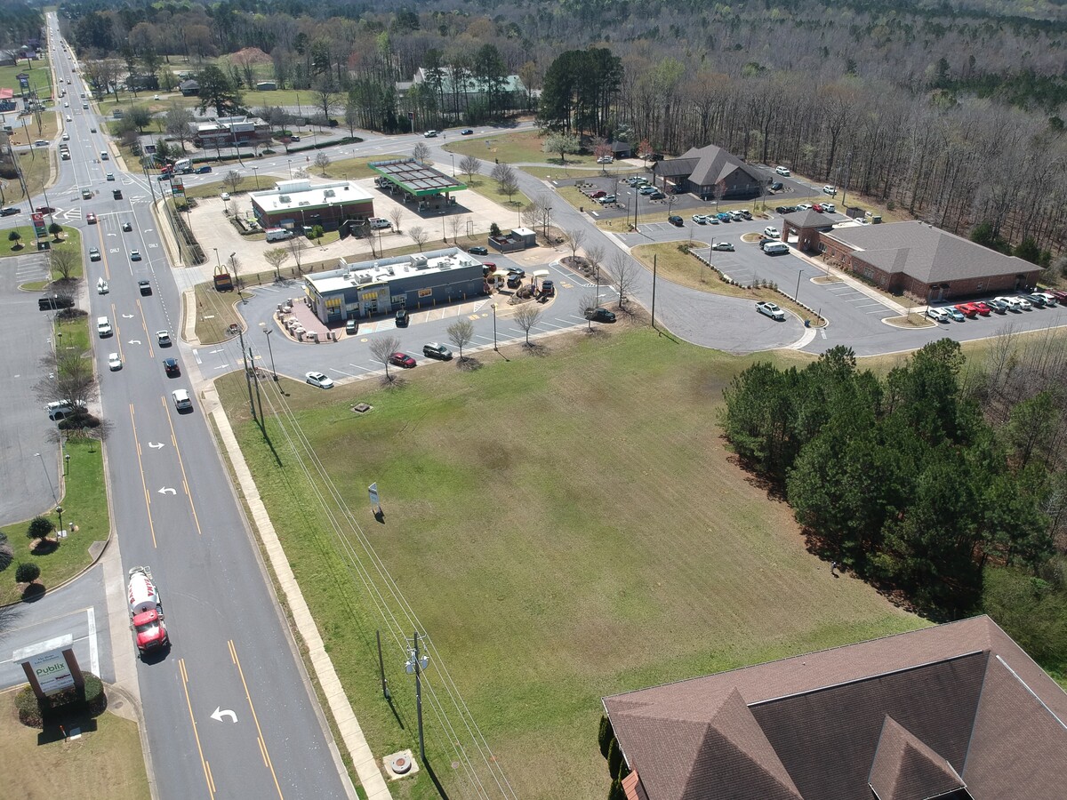
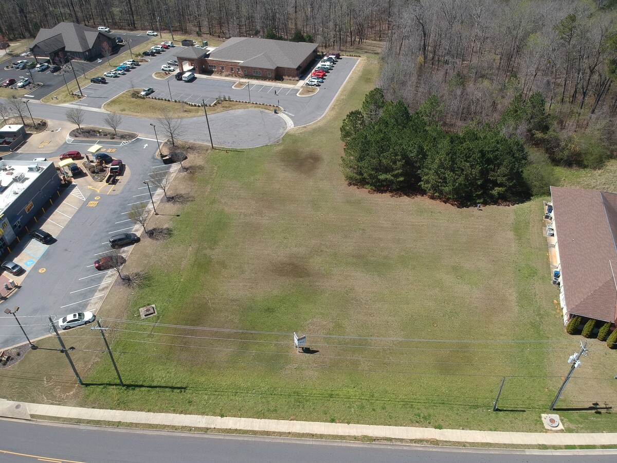
Property Record
4960 Rice Mine Rd Ne, Tuscaloosa, AL 35406

NEARBY LISTINGS FOR SALE OR LEASE
-
-
View all Tuscaloosa listings for sale on LoopNet.com
Property Detail
4960 Rice Mine Rd Ne
21-09-31-1-001-018.000
BEG 158.3 N OF SW COR NE 1/4 S31 TH RN N 250(S) E 327(S) SE 250; W 410(S) TO POB S31 T20S R09W
Medicalbuilding
Tuscaloosa
AE
Alabama
01125C0344G
2.20 AC
2024
Tuscaloosa
2024
Birmingham
010405
Tuscaloosa, AL
10,324 SF
DEMOGRAPHICS near 4960 Rice Mine Rd Ne
1 Mile
3 Mile
5 Mile
2024 Total Population
4,642
20,398
94,901
2029 Population
5,273
23,159
106,474
Pop Growth 2024-2029
+ 13.59%
+ 13.54%
+ 12.19%
Average Age
37
39
34
2024 Total Households
1,727
8,098
33,487
HH Growth 2024-2029
+ 13.84%
+ 13.44%
+ 14.92%
Median Household Inc
$124,788
$99,201
$53,114
Avg Household Size
2.60
2.40
2.20
2024 Avg HH Vehicles
2.00
2.00
2.00
Median Home Value
$425,065
$382,264
$269,339
Median Year Built
2002
1993
1992
Nearby Places
- Restaurants
- Banks
- Shops
- Fitness
- Groceries
PUBLIC TRANSPORTATION
COMMUTER RAIL
Tuscaloosa Amtrak Station (Crescent - Amtrak)
DRIVE
WALK
Distance
Tuscaloosa Amtrak Station (Crescent - Amtrak)
14 min
8.1 mi
Freight Ports
Port of Mobile
DRIVE
WALK
Distance
Port of Mobile
250 min
206.7 mi
SALE & LEASE HISTORY
LISTING DATE
SALE/LEASE

Mar 30, 2022
For Sale
Nearby Properties
Address
Land Use
TOTAL SIZE
Lot Size
Zoning
Address
Land Use
TOTAL SIZE
Lot Size
Zoning
22,791 SF
13 AC
Address
Land Use
TOTAL SIZE
Lot Size
Zoning
26,440 SF
14.65 AC
RMF1
Address
Land Use
TOTAL SIZE
Lot Size
Zoning
413,194 SF
7.95 AC
Address
Land Use
TOTAL SIZE
Lot Size
Zoning
20,224 SF
19 AC
RM2
Address
Land Use
TOTAL SIZE
Lot Size
Zoning
1,490 SF
9.40 AC
R-4
Address
Land Use
TOTAL SIZE
Lot Size
Zoning
1,832 SF
19 AC
RMF-1
Address
Land Use
TOTAL SIZE
Lot Size
Zoning
12,048 SF
21 AC
RM2
Address
Land Use
TOTAL SIZE
Lot Size
Zoning
20,185 SF
25.54 AC
Address
Land Use
TOTAL SIZE
Lot Size
Zoning
26,400 SF
51.67 AC
Address
Land Use
TOTAL SIZE
Lot Size
Zoning
3,456 SF
13.98 AC
RM2
Address
Land Use
TOTAL SIZE
Lot Size
Zoning
15,060 SF
11 AC
RM2
Address
Land Use
TOTAL SIZE
Lot Size
Zoning
84,891 SF
3 AC
Address
Land Use
TOTAL SIZE
Lot Size
Zoning
24,684 SF
12 AC
RM2
Address
Land Use
TOTAL SIZE
Lot Size
Zoning
8,120 SF
13 AC
RMF1
Address
Land Use
TOTAL SIZE
Lot Size
Zoning
12,900 SF
47 AC
R1
Address
Land Use
TOTAL SIZE
Lot Size
Zoning
18 AC
BN
Address
Land Use
TOTAL SIZE
Lot Size
Zoning
6,900 SF
8.80 AC
R4
Address
Land Use
TOTAL SIZE
Lot Size
Zoning
24,048 SF
21 AC
Address
Land Use
TOTAL SIZE
Lot Size
Zoning
29,565 SF
11 AC
R1
Address
Land Use
TOTAL SIZE
Lot Size
Zoning
1,832 SF
6.80 AC
RMF-1
Address
Land Use
TOTAL SIZE
Lot Size
Zoning
21,962 SF
2.68 AC
BN
Address
Land Use
TOTAL SIZE
Lot Size
Zoning
13,234 SF
5.90 AC
RM2
Address
Land Use
TOTAL SIZE
Lot Size
Zoning
8,976 SF
7.03 AC
C3
Address
Land Use
TOTAL SIZE
Lot Size
Zoning
39,954 SF
3.39 AC
BN
Address
Land Use
TOTAL SIZE
Lot Size
Zoning
44,716 SF
5.83 AC
BN
Address
Land Use
TOTAL SIZE
Lot Size
Zoning
49,317 SF
3.30 AC
BN
Address
Land Use
TOTAL SIZE
Lot Size
Zoning
65,263 SF
15 AC
I
Address
Land Use
TOTAL SIZE
Lot Size
Zoning
62,575 SF
7.10 AC
C6
Address
Land Use
TOTAL SIZE
Lot Size
Zoning
64,683 SF
6.60 AC
BN
Address
Land Use
TOTAL SIZE
Lot Size
Zoning
18,750 SF
44 SF
The World's #1 Commercial Real Estate Marketplace
Connect with us
© 2025 CoStar Group
The information above has been obtained from sources believed reliable. While we do not doubt its accuracy we have not verified it and make no guarantee, warranty or representation about it. It is your responsibility to independently confirm its accuracy and completeness. Any projections, opinions, assumptions, or estimates used are for example only and do not represent the current or future performance of the property. The value of this transaction to you depends on tax and other factors which should be evaluated by your tax, financial, and legal advisors. You and your advisors should conduct a careful, independent investigation of the property to determine to your satisfaction the suitability of the property for your needs.