Property Record
4972 Wattsburg Rd, Erie, PA 16504
NEARBY LISTINGS FOR SALE OR LEASE
Property Detail
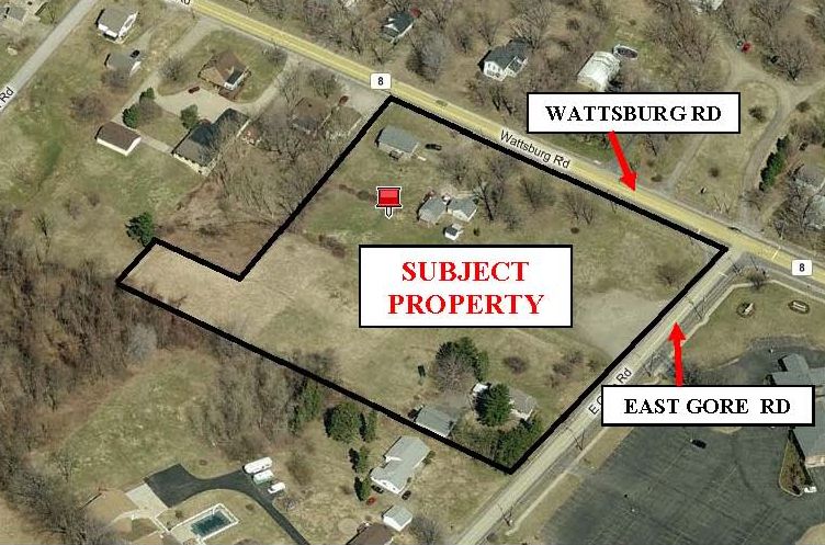
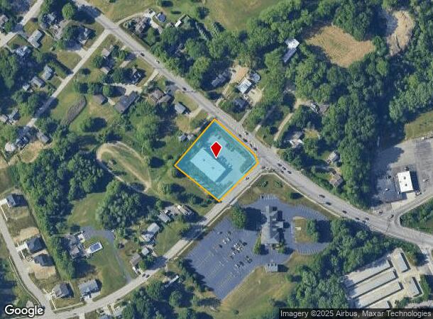
4972 Wattsburg Rd
33-105-474.0-041.00
4972 WATTSBURG RD 1.351 AC
Storebuilding
Erie
X
Pennsylvania
42049C0207D
1.39 AC
2024
Outlying Erie County
2024
Erie
011101
Erie, PA
9,100 SF
DEMOGRAPHICS near 4972 Wattsburg Rd
1 Mile
3 Mile
5 Mile
2024 Total Population
9,414
72,692
137,607
2029 Population
9,247
71,749
136,087
Pop Growth 2024-2029
(1.77%)
(1.30%)
(1.10%)
Average Age
41
39
40
2024 Total Households
3,986
28,189
56,196
HH Growth 2024-2029
(1.98%)
(1.43%)
(1.20%)
Median Household Inc
$52,675
$46,065
$47,699
Avg Household Size
2.20
2.30
2.30
2024 Avg HH Vehicles
2.00
1.00
1.00
Median Home Value
$136,234
$113,683
$122,488
Median Year Built
1975
1956
1956
Nearby Places
- Restaurants
- Banks
- Shops
- Fitness
- Groceries
PUBLIC TRANSPORTATION
COMMUTER RAIL
Erie Amtrak Station (Lake Shore Limited - Amtrak)
DRIVE
WALK
Distance
Erie Amtrak Station (Lake Shore Limited - Amtrak)
8 min
3.5 mi
AIRPORT
Erie International/Tom Ridge Field
DRIVE
WALK
Distance
Erie International/Tom Ridge Field
20 min
9.3 mi
Freight Ports
Port of Toledo
DRIVE
WALK
Distance
Port of Toledo
254 min
216.0 mi
Nearby Properties
Address
Land Use
TOTAL SIZE
Lot Size
Zoning
Address
Land Use
TOTAL SIZE
Lot Size
Zoning
104,159 SF
255.72 AC
B1
Address
Land Use
TOTAL SIZE
Lot Size
Zoning
31,764 SF
46.83 AC
R3
Address
Land Use
TOTAL SIZE
Lot Size
Zoning
227,630 SF
343.90 AC
I1
Address
Land Use
TOTAL SIZE
Lot Size
Zoning
630,344 SF
7.57 AC
RLB
Address
Land Use
TOTAL SIZE
Lot Size
Zoning
5 AC
RLB
Address
Land Use
TOTAL SIZE
Lot Size
Zoning
800 SF
10.05 AC
R2
Address
Land Use
TOTAL SIZE
Lot Size
Zoning
68,626 SF
86.88 AC
B1
Address
Land Use
TOTAL SIZE
Lot Size
Zoning
170,870 SF
4.51 AC
RLB
Address
Land Use
TOTAL SIZE
Lot Size
Zoning
8.60 AC
R2
Address
Land Use
TOTAL SIZE
Lot Size
Zoning
23,092 SF
31.24 AC
DR
Address
Land Use
TOTAL SIZE
Lot Size
Zoning
163,596 SF
14.31 AC
C2
Address
Land Use
TOTAL SIZE
Lot Size
Zoning
38 AC
AR
Address
Land Use
TOTAL SIZE
Lot Size
Zoning
24,467 SF
8.97 AC
RLB
Address
Land Use
TOTAL SIZE
Lot Size
Zoning
178,236 SF
26.15 AC
RLB
Address
Land Use
TOTAL SIZE
Lot Size
Zoning
18.55 AC
M1
Address
Land Use
TOTAL SIZE
Lot Size
Zoning
88,232 SF
1 AC
RLB
Address
Land Use
TOTAL SIZE
Lot Size
Zoning
103,790 SF
3.45 AC
C3
Address
Land Use
TOTAL SIZE
Lot Size
Zoning
70,092 SF
10.78 AC
DR
Address
Land Use
TOTAL SIZE
Lot Size
Zoning
59,300 SF
16.25 AC
Address
Land Use
TOTAL SIZE
Lot Size
Zoning
70,972 SF
4.10 AC
RLB
Address
Land Use
TOTAL SIZE
Lot Size
Zoning
23.95 AC
DR
Address
Land Use
TOTAL SIZE
Lot Size
Zoning
77,126 SF
8.85 AC
C1
Address
Land Use
TOTAL SIZE
Lot Size
Zoning
268,264 SF
1.55 AC
RLB
Address
Land Use
TOTAL SIZE
Lot Size
Zoning
41,976 SF
6.50 AC
R2A
Address
Land Use
TOTAL SIZE
Lot Size
Zoning
158,708 SF
1.25 AC
C3
Address
Land Use
TOTAL SIZE
Lot Size
Zoning
170,870 SF
2.31 AC
RLB
Address
Land Use
TOTAL SIZE
Lot Size
Zoning
26,400 SF
106.25 AC
R1
Address
Land Use
TOTAL SIZE
Lot Size
Zoning
91,930 SF
10.18 AC
RLB
Address
Land Use
TOTAL SIZE
Lot Size
Zoning
5 AC
RLB
Address
Land Use
TOTAL SIZE
Lot Size
Zoning
4.94 AC
R3
The World's #1 Commercial Real Estate Marketplace
Connect with us
© 2025 CoStar Group
The information above has been obtained from sources believed reliable. While we do not doubt its accuracy we have not verified it and make no guarantee, warranty or representation about it. It is your responsibility to independently confirm its accuracy and completeness. Any projections, opinions, assumptions, or estimates used are for example only and do not represent the current or future performance of the property. The value of this transaction to you depends on tax and other factors which should be evaluated by your tax, financial, and legal advisors. You and your advisors should conduct a careful, independent investigation of the property to determine to your satisfaction the suitability of the property for your needs.