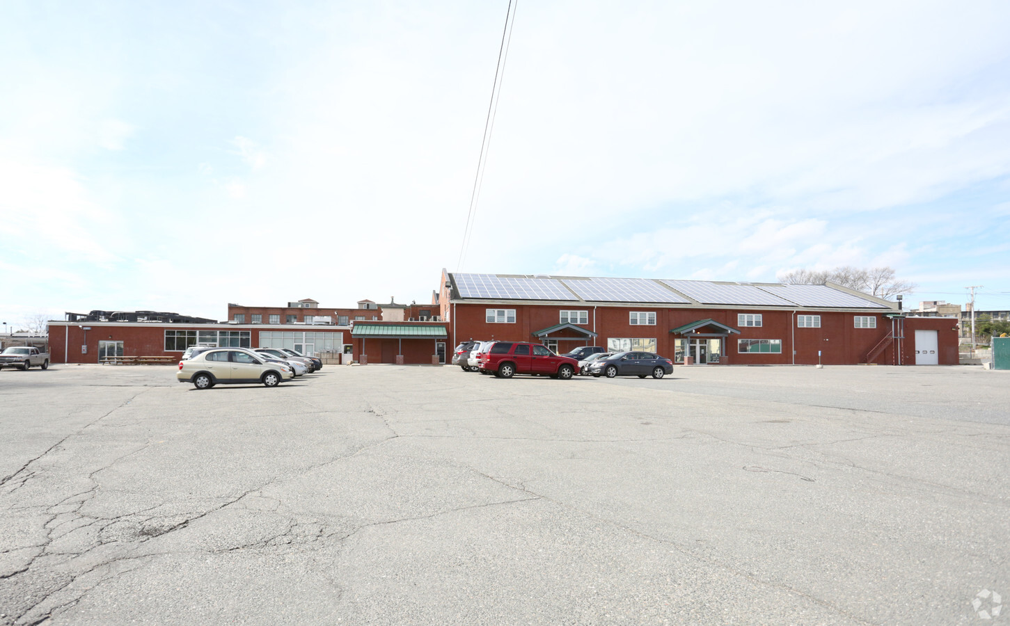
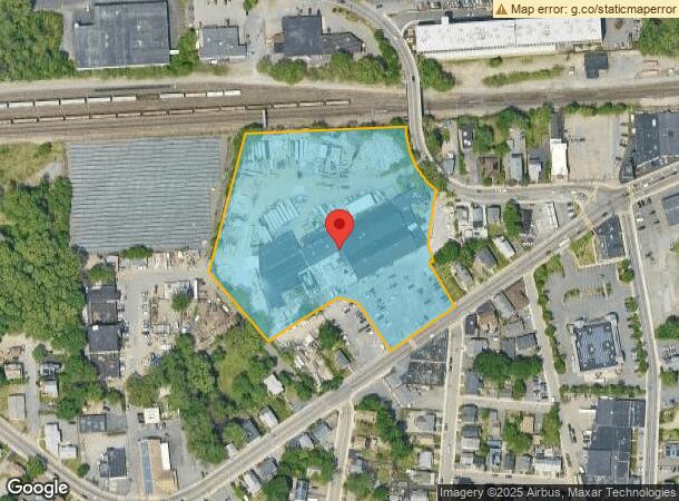
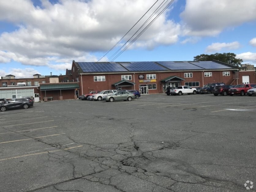
Property Record
687 Waverley St, Framingham, MA 01702
NEARBY LISTINGS FOR SALE OR LEASE
Property Detail
687 Waverley St
FRAM-000134-000054-007972
Middlesex
Departmentstore
Massachusetts
X
7972
25017C0518F
6.16 AC
2024
Framingham/Natick
2024
Boston
383300
Boston-Cambridge-Newton, MA-NH
73,445 SF
DEMOGRAPHICS near 687 Waverley St
1 Mile
3 Mile
5 Mile
2024 Total Population
15,748
77,904
144,071
2029 Population
15,635
77,359
142,989
Pop Growth 2024-2029
(0.72%)
(0.70%)
(0.75%)
Average Age
38
39
41
2024 Total Households
5,567
29,976
55,354
HH Growth 2024-2029
(0.59%)
(0.76%)
(0.84%)
Median Household Inc
$72,449
$89,621
$110,368
Avg Household Size
2.60
2.40
2.50
2024 Avg HH Vehicles
1.00
2.00
2.00
Median Home Value
$457,383
$518,716
$619,193
Median Year Built
1956
1969
1968
Nearby Places
- Restaurants
- Banks
- Shops
- Fitness
- Groceries
PUBLIC TRANSPORTATION
COMMUTER RAIL
Framingham Amtrak (Lake Shore Limited - Amtrak)
DRIVE
WALK
Distance
Framingham Amtrak (Lake Shore Limited - Amtrak)
2 min
9 min
0.5 mi
Framingham (Framingham/Worcester Line - Massachusetts Bay Transportation Authority Commuter Rail (Purple Line))
DRIVE
WALK
Distance
Framingham (Framingham/Worcester Line - Massachusetts Bay Transportation Authority Commuter Rail (Purple Line))
1 min
11 min
0.5 mi
AIRPORT
General Edward Lawrence Logan International
DRIVE
WALK
Distance
General Edward Lawrence Logan International
40 min
25.5 mi
Worcester Regional
DRIVE
WALK
Distance
Worcester Regional
47 min
26.4 mi
Freight Ports
Port of Boston
DRIVE
WALK
Distance
Port of Boston
39 min
23.8 mi
SALE & LEASE HISTORY
LISTING DATE
SALE/LEASE

Sep 24, 2016
For Lease
Nov 08, 2018
For Lease
Dec 11, 2017
For Lease
Nearby Properties
Address
Land Use
TOTAL SIZE
Lot Size
Zoning
Address
Land Use
TOTAL SIZE
Lot Size
Zoning
478,440 SF
11.97 AC
B
Address
Land Use
TOTAL SIZE
Lot Size
Zoning
94,545 SF
11.70 AC
RSA
Address
Land Use
TOTAL SIZE
Lot Size
Zoning
340,840 SF
4.25 AC
B
Address
Land Use
TOTAL SIZE
Lot Size
Zoning
137,000 SF
18.96 AC
R-1
Address
Land Use
TOTAL SIZE
Lot Size
Zoning
292,608 SF
5.19 AC
B
Address
Land Use
TOTAL SIZE
Lot Size
Zoning
293,180 SF
5.10 AC
B
Address
Land Use
TOTAL SIZE
Lot Size
Zoning
20,704 SF
13.36 AC
PCD
Address
Land Use
TOTAL SIZE
Lot Size
Zoning
315,055 SF
40.38 AC
G
Address
Land Use
TOTAL SIZE
Lot Size
Zoning
264,247 SF
6.09 AC
M-1
Address
Land Use
TOTAL SIZE
Lot Size
Zoning
273,474 SF
7.46 AC
B
Address
Land Use
TOTAL SIZE
Lot Size
Zoning
256,830 SF
12.61 AC
B
Address
Land Use
TOTAL SIZE
Lot Size
Zoning
207,522 SF
10.11 AC
B
Address
Land Use
TOTAL SIZE
Lot Size
Zoning
191,520 SF
7.99 AC
B
Address
Land Use
TOTAL SIZE
Lot Size
Zoning
191,520 SF
5.03 AC
B
Address
Land Use
TOTAL SIZE
Lot Size
Zoning
199,320 SF
16.65 AC
RSA
Address
Land Use
TOTAL SIZE
Lot Size
Zoning
139,356 SF
52 AC
30
Address
Land Use
TOTAL SIZE
Lot Size
Zoning
251,366 SF
14.42 AC
G
Address
Land Use
TOTAL SIZE
Lot Size
Zoning
231,897 SF
7.90 AC
B
Address
Land Use
TOTAL SIZE
Lot Size
Zoning
Address
Land Use
TOTAL SIZE
Lot Size
Zoning
244,033 SF
25.75 AC
R-1
Address
Land Use
TOTAL SIZE
Lot Size
Zoning
493,918 SF
28.90 AC
R-1
Address
Land Use
TOTAL SIZE
Lot Size
Zoning
204,670 SF
12.55 AC
INI
Address
Land Use
TOTAL SIZE
Lot Size
Zoning
135,535 SF
26.49 AC
B
Address
Land Use
TOTAL SIZE
Lot Size
Zoning
112,000 SF
18.48 AC
R-1
Address
Land Use
TOTAL SIZE
Lot Size
Zoning
112,000 SF
15.11 AC
G
Address
Land Use
TOTAL SIZE
Lot Size
Zoning
150,636 SF
30.34 AC
G-E
Address
Land Use
TOTAL SIZE
Lot Size
Zoning
134,776 SF
8.26 AC
M-1
Address
Land Use
TOTAL SIZE
Lot Size
Zoning
108.84 AC
M
Address
Land Use
TOTAL SIZE
Lot Size
Zoning
154,724 SF
84.88 AC
G
Address
Land Use
TOTAL SIZE
Lot Size
Zoning
41,658 SF
4.37 AC
INI
The World's #1 Commercial Real Estate Marketplace
Connect with us
© 2025 CoStar Group
The information above has been obtained from sources believed reliable. While we do not doubt its accuracy we have not verified it and make no guarantee, warranty or representation about it. It is your responsibility to independently confirm its accuracy and completeness. Any projections, opinions, assumptions, or estimates used are for example only and do not represent the current or future performance of the property. The value of this transaction to you depends on tax and other factors which should be evaluated by your tax, financial, and legal advisors. You and your advisors should conduct a careful, independent investigation of the property to determine to your satisfaction the suitability of the property for your needs.