Property Record
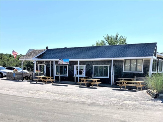
50 N Sea Dr, Southold, NY 11971


NEARBY LISTINGS FOR SALE OR LEASE
Property Detail
50 N Sea Dr
Nassau County-Suffolk County, NY
BOOK 10524 PAGE 00569 BILL 006032
1000-054-00-05-00-022-000
Suffolk
Restaurantbuilding
New York
AE
22
36103C0154H
0.53 AC
2024
Eastern Suffolk
2024
Long Island (New York)
170203
DEMOGRAPHICS near 50 N Sea Dr
1 Mile
3 Mile
5 Mile
2024 Total Population
841
7,251
15,530
2029 Population
881
7,470
16,081
Pop Growth 2024-2029
+ 4.76%
+ 3.02%
+ 3.55%
Average Age
49
49
49
2024 Total Households
373
3,069
6,612
HH Growth 2024-2029
+ 4.56%
+ 2.90%
+ 3.51%
Median Household Inc
$117,187
$93,661
$101,458
Avg Household Size
2.30
2.30
2.30
2024 Avg HH Vehicles
2.00
2.00
2.00
Median Home Value
$684,131
$720,138
$750,854
Median Year Built
1978
1973
1974
Nearby Places
Map Layers
Map Styles
 Street
 Aerial
- Restaurants
- Banks
- Shops
- Fitness
- Groceries
PUBLIC TRANSPORTATION
COMMUTER RAIL
Southold Station (Greenport Branch - Long Island Rail Road)
DRIVE
WALK
Distance
Southold Station (Greenport Branch - Long Island Rail Road)
4 min
2.1 mi
Greenport Station (Greenport Branch - Long Island Rail Road)
DRIVE
WALK
Distance
Greenport Station (Greenport Branch - Long Island Rail Road)
12 min
6.5 mi
Freight Ports
Port of New Haven
DRIVE
WALK
Distance
Port of New Haven
171 min
74.6 mi
SALE & LEASE HISTORY
LISTING DATE
SALE/LEASE

Mar 26, 2021
For Sale
Mar 26, 2021
For Sale
Aug 05, 2020
For Sale
Nearby Properties
Address
Land Use
TOTAL SIZE
Lot Size
Zoning
Address
Land Use
TOTAL SIZE
Lot Size
Zoning
38.11 AC
R-40 RO
Address
Land Use
TOTAL SIZE
Lot Size
Zoning
0.35 AC
HD
Address
Land Use
TOTAL SIZE
Lot Size
Zoning
0.02 AC
Address
Land Use
TOTAL SIZE
Lot Size
Zoning
2.60 AC
HB
Address
Land Use
TOTAL SIZE
Lot Size
Zoning
2.48 AC
Address
Land Use
TOTAL SIZE
Lot Size
Zoning
0.02 AC
Address
Land Use
TOTAL SIZE
Lot Size
Zoning
12.10 AC
R-80 B
Address
Land Use
TOTAL SIZE
Lot Size
Zoning
3.20 AC
R-80
Address
Land Use
TOTAL SIZE
Lot Size
Zoning
Address
Land Use
TOTAL SIZE
Lot Size
Zoning
10.50 AC
R-40
Address
Land Use
TOTAL SIZE
Lot Size
Zoning
4.33 AC
R-40 RO
Address
Land Use
TOTAL SIZE
Lot Size
Zoning
4.33 AC
R-80
Address
Land Use
TOTAL SIZE
Lot Size
Zoning
36.62 AC
R-80
Address
Land Use
TOTAL SIZE
Lot Size
Zoning
72.30 AC
AC R-80
Address
Land Use
TOTAL SIZE
Lot Size
Zoning
6.84 AC
AC
Address
Land Use
TOTAL SIZE
Lot Size
Zoning
Address
Land Use
TOTAL SIZE
Lot Size
Zoning
7.02 AC
LI
Address
Land Use
TOTAL SIZE
Lot Size
Zoning
5.70 AC
HB
Address
Land Use
TOTAL SIZE
Lot Size
Zoning
2.10 AC
HB B
Address
Land Use
TOTAL SIZE
Lot Size
Zoning
2.46 AC
HB
Address
Land Use
TOTAL SIZE
Lot Size
Zoning
3.15 AC
HB
Address
Land Use
TOTAL SIZE
Lot Size
Zoning
Address
Land Use
TOTAL SIZE
Lot Size
Zoning
33.68 AC
AC
Address
Land Use
TOTAL SIZE
Lot Size
Zoning
26.50 AC
RR
Address
Land Use
TOTAL SIZE
Lot Size
Zoning
84.67 AC
AC R-80
Address
Land Use
TOTAL SIZE
Lot Size
Zoning
57.10 AC
R-80
Address
Land Use
TOTAL SIZE
Lot Size
Zoning
0.92 AC
HB
Address
Land Use
TOTAL SIZE
Lot Size
Zoning
5.01 AC
MII
Address
Land Use
TOTAL SIZE
Lot Size
Zoning
2.45 AC
LB
Address
Land Use
TOTAL SIZE
Lot Size
Zoning
The World's #1 Commercial Real Estate Marketplace
Connect with us
© 2026 CoStar Group
The information above has been obtained from sources believed reliable. While we do not doubt its accuracy we have not verified it and make no guarantee, warranty or representation about it. It is your responsibility to independently confirm its accuracy and completeness. Any projections, opinions, assumptions, or estimates used are for example only and do not represent the current or future performance of the property. The value of this transaction to you depends on tax and other factors which should be evaluated by your tax, financial, and legal advisors. You and your advisors should conduct a careful, independent investigation of the property to determine to your satisfaction the suitability of the property for your needs.