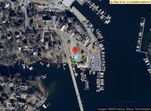
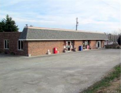
Property Record
50 Watling St, Urbanna, VA 23175

NEARBY LISTINGS FOR SALE OR LEASE
-
-
View all Urbanna listings for sale on LoopNet.com
Property Detail
50 Watling St
Storebuilding
50 WATLING STREET .516 AC D122-696,W48-159,W52-609 275-430,PL14-15
X
Middlesex
51119C0114F
Virginia
2024
0.52 AC
2024
Virginia Regional
950900
Other Market Areas
3,280 SF
20A-1-84
DEMOGRAPHICS near 50 Watling St
1 Mile
3 Mile
5 Mile
2024 Total Population
802
2,201
3,910
2029 Population
804
2,257
4,041
Pop Growth 2024-2029
+ 0.25%
+ 2.54%
+ 3.35%
Average Age
51
50
49
2024 Total Households
401
964
1,725
HH Growth 2024-2029
0.00%
+ 2.18%
+ 3.13%
Median Household Inc
$42,105
$63,913
$66,085
Avg Household Size
1.90
2.00
2.10
2024 Avg HH Vehicles
2.00
2.00
2.00
Median Home Value
$339,814
$343,697
$311,483
Median Year Built
1981
1979
1981
Nearby Places
- Restaurants
- Banks
- Shops
- Fitness
- Groceries
SALE & LEASE HISTORY
LISTING DATE
SALE/LEASE

Sep 23, 2016
For Sale
May 03, 2021
For Sale
Apr 06, 2020
For Sale
Nearby Properties
Address
Land Use
TOTAL SIZE
Lot Size
Zoning
Address
Land Use
TOTAL SIZE
Lot Size
Zoning
9,222 SF
78.66 AC
WC
Address
Land Use
TOTAL SIZE
Lot Size
Zoning
4,362 SF
2,038.47 AC
RH
Address
Land Use
TOTAL SIZE
Lot Size
Zoning
28,521 SF
2.51 AC
GB
Address
Land Use
TOTAL SIZE
Lot Size
Zoning
7.05 AC
GB
Address
Land Use
TOTAL SIZE
Lot Size
Zoning
94,203 SF
17.83 AC
VC
Address
Land Use
TOTAL SIZE
Lot Size
Zoning
12,500 SF
1.43 AC
GB
Address
Land Use
TOTAL SIZE
Lot Size
Zoning
2,164 SF
3.36 AC
GB
Address
Land Use
TOTAL SIZE
Lot Size
Zoning
8,713 SF
8.34 AC
LDR
Address
Land Use
TOTAL SIZE
Lot Size
Zoning
32,856 SF
4.39 AC
GB
Address
Land Use
TOTAL SIZE
Lot Size
Zoning
23,523 SF
7.68 AC
VC
Address
Land Use
TOTAL SIZE
Lot Size
Zoning
4,017 SF
3.28 AC
VC
Address
Land Use
TOTAL SIZE
Lot Size
Zoning
16,278 SF
2 AC
GB
Address
Land Use
TOTAL SIZE
Lot Size
Zoning
104.49 AC
VC
Address
Land Use
TOTAL SIZE
Lot Size
Zoning
9,892 SF
2.03 AC
GB
Address
Land Use
TOTAL SIZE
Lot Size
Zoning
6.67 AC
VC
Address
Land Use
TOTAL SIZE
Lot Size
Zoning
12,209 SF
0.55 AC
R
Address
Land Use
TOTAL SIZE
Lot Size
Zoning
1.63 AC
WC
Address
Land Use
TOTAL SIZE
Lot Size
Zoning
6,732 SF
3.89 AC
LDR
Address
Land Use
TOTAL SIZE
Lot Size
Zoning
7,249 SF
4.41 AC
VC
Address
Land Use
TOTAL SIZE
Lot Size
Zoning
7,868 SF
1.34 AC
VC
Address
Land Use
TOTAL SIZE
Lot Size
Zoning
10,835 SF
0.97 AC
H
Address
Land Use
TOTAL SIZE
Lot Size
Zoning
12,012 SF
0.39 AC
GB
Address
Land Use
TOTAL SIZE
Lot Size
Zoning
306.48 AC
LDR
Address
Land Use
TOTAL SIZE
Lot Size
Zoning
16,848 SF
0.93 AC
GB
Address
Land Use
TOTAL SIZE
Lot Size
Zoning
8,800 SF
2.61 AC
WC
Address
Land Use
TOTAL SIZE
Lot Size
Zoning
10,699 SF
5.35 AC
VC
Address
Land Use
TOTAL SIZE
Lot Size
Zoning
1,568 SF
0.66 AC
WC
Address
Land Use
TOTAL SIZE
Lot Size
Zoning
35.64 AC
VC
Address
Land Use
TOTAL SIZE
Lot Size
Zoning
7,540 SF
0.81 AC
LDR
The World's #1 Commercial Real Estate Marketplace
Connect with us
© 2025 CoStar Group
The information above has been obtained from sources believed reliable. While we do not doubt its accuracy we have not verified it and make no guarantee, warranty or representation about it. It is your responsibility to independently confirm its accuracy and completeness. Any projections, opinions, assumptions, or estimates used are for example only and do not represent the current or future performance of the property. The value of this transaction to you depends on tax and other factors which should be evaluated by your tax, financial, and legal advisors. You and your advisors should conduct a careful, independent investigation of the property to determine to your satisfaction the suitability of the property for your needs.