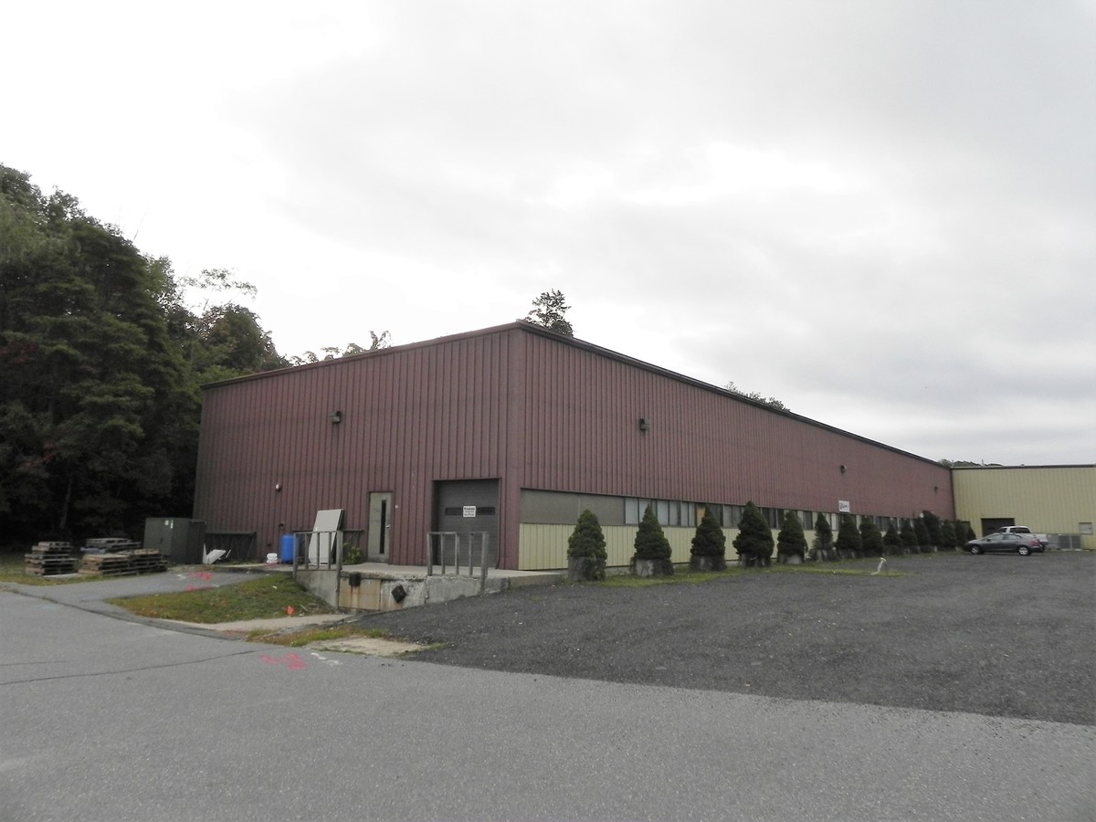
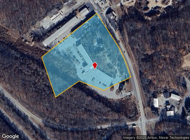
Property Record
500 Main St, Deep River, CT 06417
NEARBY LISTINGS FOR SALE OR LEASE
Property Detail
500 Main St
DEEP-000059-000000-000011
Middlesex
Industrialgeneral
Connecticut
X
11
09011C0435G
8.29 AC
2024
SW Midlsx/Old Saybrk
2024
Hartford
620100
Hartford-West Hartford-East Hartford, CT
DEMOGRAPHICS near 500 Main St
1 Mile
3 Mile
5 Mile
2024 Total Population
743
11,313
21,752
2029 Population
739
11,275
21,669
Pop Growth 2024-2029
(0.54%)
(0.34%)
(0.38%)
Average Age
48
49
48
2024 Total Households
345
5,111
9,262
HH Growth 2024-2029
(0.58%)
(0.43%)
(0.51%)
Median Household Inc
$97,832
$93,204
$101,578
Avg Household Size
2.10
2.10
2.30
2024 Avg HH Vehicles
2.00
2.00
2.00
Median Home Value
$333,333
$394,465
$393,872
Median Year Built
1965
1965
1970
Nearby Places
- Restaurants
- Banks
- Shops
- Fitness
- Groceries
PUBLIC TRANSPORTATION
COMMUTER RAIL
Westbrook (Shore Line East - Shore Line East)
DRIVE
WALK
Distance
Westbrook (Shore Line East - Shore Line East)
12 min
6.2 mi
Old Saybrook (Shore Line East - Shore Line East)
DRIVE
WALK
Distance
Old Saybrook (Shore Line East - Shore Line East)
11 min
6.5 mi
AIRPORT
Tweed/New Haven
DRIVE
WALK
Distance
Tweed/New Haven
43 min
30.1 mi
Freight Ports
Port of New Haven
DRIVE
WALK
Distance
Port of New Haven
43 min
30.7 mi
SALE & LEASE HISTORY
LISTING DATE
SALE/LEASE

Oct 04, 2016
For Lease
Nearby Properties
Address
Land Use
TOTAL SIZE
Lot Size
Zoning
Address
Land Use
TOTAL SIZE
Lot Size
Zoning
66.05 AC
PRD
Address
Land Use
TOTAL SIZE
Lot Size
Zoning
108.89 AC
Address
Land Use
TOTAL SIZE
Lot Size
Zoning
84.30 AC
R60
Address
Land Use
TOTAL SIZE
Lot Size
Zoning
38.67 AC
R60
Address
Land Use
TOTAL SIZE
Lot Size
Zoning
2,100 SF
434.75 AC
R80
Address
Land Use
TOTAL SIZE
Lot Size
Zoning
7.60 AC
VRD
Address
Land Use
TOTAL SIZE
Lot Size
Zoning
189,678 SF
44.72 AC
Address
Land Use
TOTAL SIZE
Lot Size
Zoning
14.98 AC
Address
Land Use
TOTAL SIZE
Lot Size
Zoning
43,023 SF
1.08 AC
GCD
Address
Land Use
TOTAL SIZE
Lot Size
Zoning
18.49 AC
HDD
Address
Land Use
TOTAL SIZE
Lot Size
Zoning
120,144 SF
17.10 AC
RLM
Address
Land Use
TOTAL SIZE
Lot Size
Zoning
18.90 AC
WD2
Address
Land Use
TOTAL SIZE
Lot Size
Zoning
151,159 SF
6.30 AC
VID
Address
Land Use
TOTAL SIZE
Lot Size
Zoning
18,494 SF
10.40 AC
Address
Land Use
TOTAL SIZE
Lot Size
Zoning
18.80 AC
Address
Land Use
TOTAL SIZE
Lot Size
Zoning
13,739 SF
0.65 AC
VCD
Address
Land Use
TOTAL SIZE
Lot Size
Zoning
62.50 AC
Address
Land Use
TOTAL SIZE
Lot Size
Zoning
3.87 AC
Address
Land Use
TOTAL SIZE
Lot Size
Zoning
8.52 AC
Address
Land Use
TOTAL SIZE
Lot Size
Zoning
146,466 SF
13.55 AC
VID
Address
Land Use
TOTAL SIZE
Lot Size
Zoning
15,236 SF
4 AC
Address
Land Use
TOTAL SIZE
Lot Size
Zoning
27,277 SF
Address
Land Use
TOTAL SIZE
Lot Size
Zoning
13.23 AC
Address
Land Use
TOTAL SIZE
Lot Size
Zoning
5.12 AC
Address
Land Use
TOTAL SIZE
Lot Size
Zoning
27,225 SF
2.45 AC
VCD
Address
Land Use
TOTAL SIZE
Lot Size
Zoning
0.78 AC
Address
Land Use
TOTAL SIZE
Lot Size
Zoning
6.51 AC
R80
Address
Land Use
TOTAL SIZE
Lot Size
Zoning
14,382 SF
1.87 AC
VMU
Address
Land Use
TOTAL SIZE
Lot Size
Zoning
15,730 SF
2.19 AC
Address
Land Use
TOTAL SIZE
Lot Size
Zoning
25,248 SF
1.65 AC
The World's #1 Commercial Real Estate Marketplace
Connect with us
© 2025 CoStar Group
The information above has been obtained from sources believed reliable. While we do not doubt its accuracy we have not verified it and make no guarantee, warranty or representation about it. It is your responsibility to independently confirm its accuracy and completeness. Any projections, opinions, assumptions, or estimates used are for example only and do not represent the current or future performance of the property. The value of this transaction to you depends on tax and other factors which should be evaluated by your tax, financial, and legal advisors. You and your advisors should conduct a careful, independent investigation of the property to determine to your satisfaction the suitability of the property for your needs.