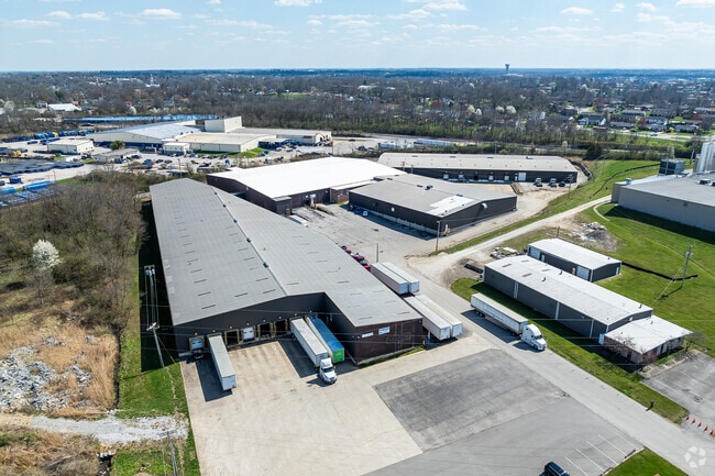
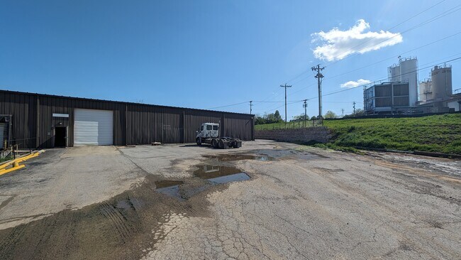
Property Record
500 Memorial Dr, Nicholasville, KY 40356


NEARBY LISTINGS FOR SALE OR LEASE
Property Detail
500 Memorial Dr
046-00-00-020.00
Industrial Park
Multipleuses
TR2-2A-P3
X
Jessamine
21113C0064D
Kentucky
2025
6 AC
2025
Jessamine County
060104
Lexington/Fayette
194,640 SF
Lexington-Fayette, KY
DEMOGRAPHICS near 500 Memorial Dr
1 Mile
3 Mile
5 Mile
2024 Total Population
12,116
31,798
42,430
2029 Population
12,791
33,528
44,715
Pop Growth 2024-2029
+ 5.57%
+ 5.44%
+ 5.39%
Average Age
38
37
38
2024 Total Households
4,680
11,896
15,456
HH Growth 2024-2029
+ 5.58%
+ 5.46%
+ 5.47%
Median Household Inc
$53,803
$58,654
$62,233
Avg Household Size
2.50
2.60
2.60
2024 Avg HH Vehicles
2.00
2.00
2.00
Median Home Value
$163,344
$171,821
$187,683
Median Year Built
1984
1987
1989
Nearby Places
Map Layers
Map Styles
 Street
 Aerial
- Restaurants
- Banks
- Shops
- Fitness
- Groceries
PUBLIC TRANSPORTATION
AIRPORT
Blue Grass
DRIVE
WALK
Distance
Blue Grass
26 min
17.1 mi
Freight Ports
Port of Toledo
DRIVE
WALK
Distance
Port of Toledo
355 min
301.1 mi
SALE & LEASE HISTORY
LISTING DATE
SALE/LEASE

Oct 25, 2022
For Lease
Oct 13, 2022
For Lease
May 15, 2018
For Sale
Jul 30, 2023
For Lease
Jul 21, 2025
For Lease
Dec 03, 2018
For Lease
Nearby Properties
Address
Land Use
TOTAL SIZE
Lot Size
Zoning
Address
Land Use
TOTAL SIZE
Lot Size
Zoning
Address
Land Use
TOTAL SIZE
Lot Size
Zoning
444,063 SF
26.02 AC
Address
Land Use
TOTAL SIZE
Lot Size
Zoning
Address
Land Use
TOTAL SIZE
Lot Size
Zoning
Address
Land Use
TOTAL SIZE
Lot Size
Zoning
41,467 SF
56 AC
Address
Land Use
TOTAL SIZE
Lot Size
Zoning
39,277 SF
15 AC
Address
Land Use
TOTAL SIZE
Lot Size
Zoning
352,363 SF
33.16 AC
Address
Land Use
TOTAL SIZE
Lot Size
Zoning
200,857 SF
22.84 AC
Address
Land Use
TOTAL SIZE
Lot Size
Zoning
11,725 SF
10 AC
Address
Land Use
TOTAL SIZE
Lot Size
Zoning
146,911 SF
10 AC
Address
Land Use
TOTAL SIZE
Lot Size
Zoning
Address
Land Use
TOTAL SIZE
Lot Size
Zoning
Address
Land Use
TOTAL SIZE
Lot Size
Zoning
138,310 SF
15.06 AC
Address
Land Use
TOTAL SIZE
Lot Size
Zoning
20,865 SF
4 AC
Address
Land Use
TOTAL SIZE
Lot Size
Zoning
57,093 SF
283.14 AC
Address
Land Use
TOTAL SIZE
Lot Size
Zoning
46,172 SF
6 AC
Address
Land Use
TOTAL SIZE
Lot Size
Zoning
18,034 SF
9 AC
Address
Land Use
TOTAL SIZE
Lot Size
Zoning
19,154 SF
5 AC
Address
Land Use
TOTAL SIZE
Lot Size
Zoning
9,000 SF
7 AC
Address
Land Use
TOTAL SIZE
Lot Size
Zoning
112,260 SF
40.90 AC
Address
Land Use
TOTAL SIZE
Lot Size
Zoning
47,602 SF
29 AC
Address
Land Use
TOTAL SIZE
Lot Size
Zoning
2,000 SF
29 AC
Address
Land Use
TOTAL SIZE
Lot Size
Zoning
150,000 SF
10 AC
Address
Land Use
TOTAL SIZE
Lot Size
Zoning
61,840 SF
6 AC
Address
Land Use
TOTAL SIZE
Lot Size
Zoning
24,079 SF
7.31 AC
Address
Land Use
TOTAL SIZE
Lot Size
Zoning
78,276 SF
20 AC
Address
Land Use
TOTAL SIZE
Lot Size
Zoning
169,942 SF
10 AC
Address
Land Use
TOTAL SIZE
Lot Size
Zoning
23,456 SF
4 AC
Address
Land Use
TOTAL SIZE
Lot Size
Zoning
66,914 SF
9 AC
The World's #1 Commercial Real Estate Marketplace
Connect with us
© 2026 CoStar Group
The information above has been obtained from sources believed reliable. While we do not doubt its accuracy we have not verified it and make no guarantee, warranty or representation about it. It is your responsibility to independently confirm its accuracy and completeness. Any projections, opinions, assumptions, or estimates used are for example only and do not represent the current or future performance of the property. The value of this transaction to you depends on tax and other factors which should be evaluated by your tax, financial, and legal advisors. You and your advisors should conduct a careful, independent investigation of the property to determine to your satisfaction the suitability of the property for your needs.