Property Record
500 S 4Th St, Eagle, NE 68347
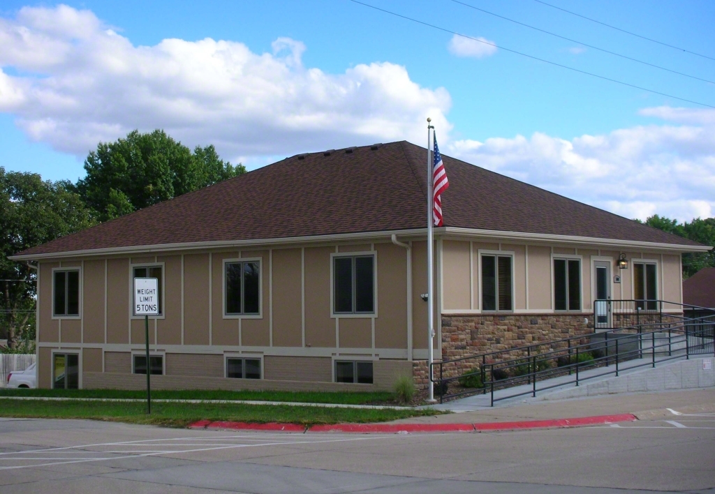


This Property Is For Sale
Current Lease Availabilities
NEARBY LISTINGS FOR SALE OR LEASE
Property Detail
500 S 4Th St
Omaha-Council Bluffs, NE-IA
Town Of Eagle
130024325
EAGLE - OT LOTS 14 TO 18 BLK 18
Officebuilding
Cass
X
Nebraska
31109C0360F
14-18
2023
0.31 AC
2023
W Cass County
965900
Omaha/Council Bluffs
2,200 SF
DEMOGRAPHICS near 500 S 4Th St
1 Mile
3 Mile
5 Mile
2024 Total Population
1,317
2,261
3,265
2029 Population
1,364
2,335
3,348
Pop Growth 2024-2029
+ 3.57%
+ 3.27%
+ 2.54%
Average Age
39
39
40
2024 Total Households
480
828
1,215
HH Growth 2024-2029
+ 3.54%
+ 3.14%
+ 2.55%
Median Household Inc
$80,882
$82,255
$85,816
Avg Household Size
2.80
2.70
2.70
2024 Avg HH Vehicles
2.00
2.00
2.00
Median Home Value
$246,987
$253,496
$267,201
Median Year Built
1985
1984
1981
Nearby Places
- Restaurants
- Banks
- Shops
- Fitness
- Groceries
PUBLIC TRANSPORTATION
AIRPORT
Lincoln
Drive
Walk
Distance
Lincoln
32 min
20.0 mi
Freight Ports
Tulsa Port Of Catoosa
Drive
Walk
Distance
Tulsa Port Of Catoosa
456 min
382.8 mi
Nearby Properties
Address
Land Use
TOTAL SIZE
Lot Size
Zoning
Address
Land Use
TOTAL SIZE
Lot Size
Zoning
22500
20 AC
04-INDUSTR
Address
Land Use
TOTAL SIZE
Lot Size
Zoning
9600
5.34 AC
03-COMMERC
Address
Land Use
TOTAL SIZE
Lot Size
Zoning
4065
1.68 AC
03-COMMERC
Address
Land Use
TOTAL SIZE
Lot Size
Zoning
8960
1.20 AC
03-COMMERC
Address
Land Use
TOTAL SIZE
Lot Size
Zoning
6540
19.11 AC
NULL
Address
Land Use
TOTAL SIZE
Lot Size
Zoning
4930
78.71 AC
NULL
Address
Land Use
TOTAL SIZE
Lot Size
Zoning
4544
62.68 AC
03-COMMERC
Address
Land Use
TOTAL SIZE
Lot Size
Zoning
4518
20.01 AC
Address
Land Use
TOTAL SIZE
Lot Size
Zoning
160 AC
05-AGRICUL
Address
Land Use
TOTAL SIZE
Lot Size
Zoning
5733
20.48 AC
AG
Address
Land Use
TOTAL SIZE
Lot Size
Zoning
3264
83.76 AC
Address
Land Use
TOTAL SIZE
Lot Size
Zoning
2944
157.75 AC
NULL
Address
Land Use
TOTAL SIZE
Lot Size
Zoning
3910
21.27 AC
NULL
Address
Land Use
TOTAL SIZE
Lot Size
Zoning
5500
20.80 AC
Address
Land Use
TOTAL SIZE
Lot Size
Zoning
160.24 AC
AGRICULTUR
Address
Land Use
TOTAL SIZE
Lot Size
Zoning
150.41 AC
AGRICULTUR
Address
Land Use
TOTAL SIZE
Lot Size
Zoning
147.17 AC
05-AGRICUL
Address
Land Use
TOTAL SIZE
Lot Size
Zoning
4465
35.37 AC
NULL
Address
Land Use
TOTAL SIZE
Lot Size
Zoning
145.61 AC
05-AGRICUL
Address
Land Use
TOTAL SIZE
Lot Size
Zoning
3801
5.89 AC
Address
Land Use
TOTAL SIZE
Lot Size
Zoning
4280
11.81 AC
NULL
Address
Land Use
TOTAL SIZE
Lot Size
Zoning
135.81 AC
05-AGRICUL
Address
Land Use
TOTAL SIZE
Lot Size
Zoning
3992
10.80 AC
NULL
Address
Land Use
TOTAL SIZE
Lot Size
Zoning
2988
20.01 AC
NULL
Address
Land Use
TOTAL SIZE
Lot Size
Zoning
3692
10.32 AC
AG
Address
Land Use
TOTAL SIZE
Lot Size
Zoning
102.05 AC
05-AGRICUL
Address
Land Use
TOTAL SIZE
Lot Size
Zoning
1188
0.25 AC
03-COMMERC
Address
Land Use
TOTAL SIZE
Lot Size
Zoning
105.09 AC
AGRICULTUR
Address
Land Use
TOTAL SIZE
Lot Size
Zoning
102.62 AC
05-AGRICUL
Address
Land Use
TOTAL SIZE
Lot Size
Zoning
8100
1 AC
03-COMMERC
Start a new search to find other properties for sale or lease
Connect with us
© 2024 CoStar Group
The information above has been obtained from sources believed reliable. While we do not doubt its accuracy we have not verified it and make no guarantee, warranty or representation about it. It is your responsibility to independently confirm its accuracy and completeness. Any projections, opinions, assumptions, or estimates used are for example only and do not represent the current or future performance of the property. The value of this transaction to you depends on tax and other factors which should be evaluated by your tax, financial, and legal advisors. You and your advisors should conduct a careful, independent investigation of the property to determine to your satisfaction the suitability of the property for your needs.