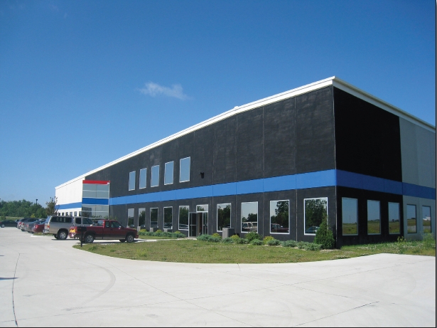
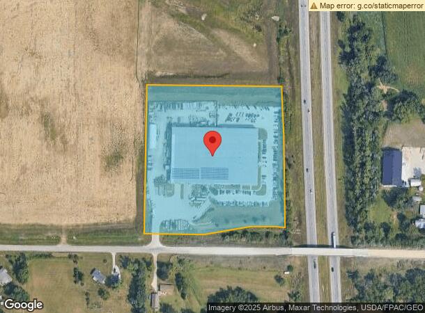
Property Record
500 Walford Rd, Cedar Rapids, IA 52404
NEARBY LISTINGS FOR SALE OR LEASE
Property Detail
500 Walford Rd
19283-51004-00000
Hughes Group 1St
Warehouse
HUGHES GROUP 1ST LOT 1
X
Linn
19113C0420E
Iowa
2023
1
2023
8.10 AC
010700
Other Market Areas
82,926 SF
Cedar Rapids, IA
DEMOGRAPHICS near 500 Walford Rd
1 Mile
3 Mile
5 Mile
2024 Total Population
51
5,776
18,593
2029 Population
49
5,826
18,663
Pop Growth 2024-2029
(3.92%)
+ 0.87%
+ 0.38%
Average Age
38
35
37
2024 Total Households
19
2,192
7,302
HH Growth 2024-2029
(5.26%)
+ 0.96%
+ 0.38%
Median Household Inc
$99,999
$79,571
$71,541
Avg Household Size
2.70
2.50
2.40
2024 Avg HH Vehicles
2.00
2.00
2.00
Median Home Value
$256,249
$237,026
$242,476
Median Year Built
2001
1995
1991
Nearby Places
- Restaurants
- Banks
- Shops
- Fitness
- Groceries
PUBLIC TRANSPORTATION
AIRPORT
The Eastern Iowa
DRIVE
WALK
Distance
The Eastern Iowa
10 min
4.3 mi
Freight Ports
Port Milwaukee
DRIVE
WALK
Distance
Port Milwaukee
305 min
255.4 mi
Nearby Properties
Address
Land Use
TOTAL SIZE
Lot Size
Zoning
Address
Land Use
TOTAL SIZE
Lot Size
Zoning
269,397 SF
153.18 AC
Address
Land Use
TOTAL SIZE
Lot Size
Zoning
486,932 SF
40.73 AC
Address
Land Use
TOTAL SIZE
Lot Size
Zoning
937.94 AC
Address
Land Use
TOTAL SIZE
Lot Size
Zoning
231,824 SF
31.61 AC
Address
Land Use
TOTAL SIZE
Lot Size
Zoning
142,137 SF
38.23 AC
Address
Land Use
TOTAL SIZE
Lot Size
Zoning
592,459 SF
45.65 AC
Address
Land Use
TOTAL SIZE
Lot Size
Zoning
350,770 SF
20.88 AC
Address
Land Use
TOTAL SIZE
Lot Size
Zoning
203,840 SF
18.22 AC
Address
Land Use
TOTAL SIZE
Lot Size
Zoning
202,682 SF
23 AC
Address
Land Use
TOTAL SIZE
Lot Size
Zoning
101,447 SF
14.42 AC
Address
Land Use
TOTAL SIZE
Lot Size
Zoning
203,272 SF
17.80 AC
Address
Land Use
TOTAL SIZE
Lot Size
Zoning
44,520 SF
0.70 AC
Address
Land Use
TOTAL SIZE
Lot Size
Zoning
91,892 SF
13.97 AC
Address
Land Use
TOTAL SIZE
Lot Size
Zoning
61,850 SF
14.85 AC
Address
Land Use
TOTAL SIZE
Lot Size
Zoning
27,071 SF
4.12 AC
Address
Land Use
TOTAL SIZE
Lot Size
Zoning
11,805 SF
148.88 AC
Address
Land Use
TOTAL SIZE
Lot Size
Zoning
149,550 SF
9.63 AC
Address
Land Use
TOTAL SIZE
Lot Size
Zoning
Address
Land Use
TOTAL SIZE
Lot Size
Zoning
122,605 SF
9.98 AC
Address
Land Use
TOTAL SIZE
Lot Size
Zoning
49,831 SF
6.79 AC
Address
Land Use
TOTAL SIZE
Lot Size
Zoning
110,231 SF
30.13 AC
Address
Land Use
TOTAL SIZE
Lot Size
Zoning
146,056 SF
13.76 AC
Address
Land Use
TOTAL SIZE
Lot Size
Zoning
89,269 SF
8.20 AC
Address
Land Use
TOTAL SIZE
Lot Size
Zoning
115,752 SF
11 AC
Address
Land Use
TOTAL SIZE
Lot Size
Zoning
110,240 SF
7.56 AC
Address
Land Use
TOTAL SIZE
Lot Size
Zoning
67,144 SF
11.54 AC
AG
Address
Land Use
TOTAL SIZE
Lot Size
Zoning
111,158 SF
9.20 AC
Address
Land Use
TOTAL SIZE
Lot Size
Zoning
100,000 SF
5.72 AC
Address
Land Use
TOTAL SIZE
Lot Size
Zoning
8,055 SF
11.09 AC
Address
Land Use
TOTAL SIZE
Lot Size
Zoning
37,500 SF
14.45 AC
The World's #1 Commercial Real Estate Marketplace
Connect with us
© 2025 CoStar Group
The information above has been obtained from sources believed reliable. While we do not doubt its accuracy we have not verified it and make no guarantee, warranty or representation about it. It is your responsibility to independently confirm its accuracy and completeness. Any projections, opinions, assumptions, or estimates used are for example only and do not represent the current or future performance of the property. The value of this transaction to you depends on tax and other factors which should be evaluated by your tax, financial, and legal advisors. You and your advisors should conduct a careful, independent investigation of the property to determine to your satisfaction the suitability of the property for your needs.