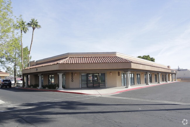
Property Record
5000 W Oakey Blvd, Las Vegas, NV 89146


Current Lease Availabilities
Property Detail
5000 W Oakey Blvd
Las Vegas-Henderson-North Las Vegas, NV
PARCEL MAP FILE 119 PAGE 20 LOT 1
163-01-602-008
Clark
Commercialnec
Nevada
B and X Area of moderate flood hazard, usually the area between the limits of the 100-year and 500-year floods.
1
2026
4.96 AC
2026
West Las Vegas
001003
Las Vegas
82,136 SF
NEARBY LISTINGS FOR SALE OR LEASE
DEMOGRAPHICS near 5000 W Oakey Blvd
1 mile
3 mile
5 mile
2025 Total Population
21,532
187,395
500,674
2030 Population
22,634
198,231
526,991
Pop Growth 2025-2030
+ 5.12%
+ 5.78%
+ 5.26%
Average Age
41
39
40
2025 Total Households
8,276
71,739
200,704
HH Growth 2025-2030
+ 5.28%
+ 5.95%
+ 5.38%
Median Household Inc
$56,644
$57,072
$57,495
Avg Household Size
2.50
2.50
2.40
2025 Avg HH Vehicles
1.00
2.00
1.00
Median Home Value
$353,022
$368,467
$379,276
Median Year Built
1978
1981
1987
Nearby Places
Map Layers
Map Styles
 Street
 Aerial
Layers
 Traffic
 Biking
Places
Listings with unknown addresses are not visible on the map
- Restaurants
- Banks
- Shops
- Fitness
- Groceries
PUBLIC TRANSPORTATION
AIRPORT
Harry Reid International
Drive
Walk
Distance
Harry Reid International
16 min
8.1 mi
Boulder City Municipal
Drive
Walk
Distance
Boulder City Municipal
41 min
31.3 mi
Freight Ports
Port of Long Beach
Drive
Walk
Distance
Port of Long Beach
318 min
283.3 mi
Nearby Properties
Address
Land Use
TOTAL SIZE
Lot Size
Zoning
Address
Land Use
TOTAL SIZE
Lot Size
Zoning
1,044,724 SF
56.56 AC
Address
Land Use
TOTAL SIZE
Lot Size
Zoning
1,447,338 SF
65.25 AC
H1
Address
Land Use
TOTAL SIZE
Lot Size
Zoning
248,689 SF
19.45 AC
H1
Address
Land Use
TOTAL SIZE
Lot Size
Zoning
659,669 SF
24.79 AC
H1
Address
Land Use
TOTAL SIZE
Lot Size
Zoning
1,069,498 SF
28.36 AC
H1
Address
Land Use
TOTAL SIZE
Lot Size
Zoning
497,331 SF
24.44 AC
Address
Land Use
TOTAL SIZE
Lot Size
Zoning
34,354 SF
33.06 AC
Address
Land Use
TOTAL SIZE
Lot Size
Zoning
115,059 SF
30.12 AC
Address
Land Use
TOTAL SIZE
Lot Size
Zoning
24,965 SF
25.75 AC
Address
Land Use
TOTAL SIZE
Lot Size
Zoning
962,611 SF
28.43 AC
Address
Land Use
TOTAL SIZE
Lot Size
Zoning
80.45 AC
CV
Address
Land Use
TOTAL SIZE
Lot Size
Zoning
573,491 SF
38.94 AC
Address
Land Use
TOTAL SIZE
Lot Size
Zoning
109,306 SF
25.79 AC
H1
Address
Land Use
TOTAL SIZE
Lot Size
Zoning
34.83 AC
CV
Address
Land Use
TOTAL SIZE
Lot Size
Zoning
814,789 SF
13.75 AC
C1
Address
Land Use
TOTAL SIZE
Lot Size
Zoning
7,630 SF
12.71 AC
H1
Address
Land Use
TOTAL SIZE
Lot Size
Zoning
64,229 SF
15.49 AC
Address
Land Use
TOTAL SIZE
Lot Size
Zoning
443,153 SF
7.13 AC
H1
Address
Land Use
TOTAL SIZE
Lot Size
Zoning
88,160 SF
18.56 AC
Address
Land Use
TOTAL SIZE
Lot Size
Zoning
8.96 AC
L:PD
Address
Land Use
TOTAL SIZE
Lot Size
Zoning
6,310 SF
3.68 AC
Address
Land Use
TOTAL SIZE
Lot Size
Zoning
17,454 SF
2.51 AC
L:C-2
Address
Land Use
TOTAL SIZE
Lot Size
Zoning
22,018 SF
6.91 AC
Address
Land Use
TOTAL SIZE
Lot Size
Zoning
8,523 SF
6.06 AC
Address
Land Use
TOTAL SIZE
Lot Size
Zoning
71,155 SF
0.22 AC
Address
Land Use
TOTAL SIZE
Lot Size
Zoning
49,716 SF
59.37 AC
CV
Address
Land Use
TOTAL SIZE
Lot Size
Zoning
5.31 AC
CV
The World's #1 Commercial Real Estate Marketplace
Connect with us
© 2026 CoStar Group
The information above has been obtained from sources believed reliable. While we do not doubt its accuracy we have not verified it and make no guarantee, warranty or representation about it. It is your responsibility to independently confirm its accuracy and completeness. Any projections, opinions, assumptions, or estimates used are for example only and do not represent the current or future performance of the property. The value of this transaction to you depends on tax and other factors which should be evaluated by your tax, financial, and legal advisors. You and your advisors should conduct a careful, independent investigation of the property to determine to your satisfaction the suitability of the property for your needs.