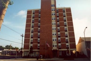
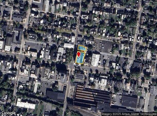
Property Record
501 E High St, Norristown, PA 19401
NEARBY LISTINGS FOR SALE OR LEASE
-
-
No Photo
-
View all Norristown listings for sale on LoopNet.com
Property Detail
501 E High St
16-00-14992-004
U 44-64
Governmentalpublicusegeneral
Montgomery
X
Pennsylvania
42029C0015G
44
0
0.39 AC
2024
Upper Montgomery County
203902
Philadelphia
47,888 SF
Philadelphia-Camden-Wilmington, PA-NJ-DE-MD
DEMOGRAPHICS near 501 E High St
1 Mile
3 Mile
5 Mile
2024 Total Population
16,615
51,487
84,226
2029 Population
16,884
52,575
85,912
Pop Growth 2024-2029
+ 1.62%
+ 2.11%
+ 2.00%
Average Age
38
40
41
2024 Total Households
6,766
20,395
32,275
HH Growth 2024-2029
+ 1.63%
+ 2.14%
+ 2.03%
Median Household Inc
$49,100
$67,332
$80,811
Avg Household Size
2.30
2.40
2.50
2024 Avg HH Vehicles
2.00
2.00
2.00
Median Home Value
$126,361
$193,870
$256,343
Median Year Built
1947
1960
1970
Nearby Places
- Restaurants
- Banks
- Shops
- Fitness
- Groceries
Nearby Properties
Address
Land Use
TOTAL SIZE
Lot Size
Zoning
Address
Land Use
TOTAL SIZE
Lot Size
Zoning
707,965 SF
80.33 AC
RMHD
Address
Land Use
TOTAL SIZE
Lot Size
Zoning
406,166 SF
65.54 AC
C
Address
Land Use
TOTAL SIZE
Lot Size
Zoning
327,827 SF
21 AC
RMD
Address
Land Use
TOTAL SIZE
Lot Size
Zoning
309,443 SF
20.56 AC
GE
Address
Land Use
TOTAL SIZE
Lot Size
Zoning
172,766 SF
43.12 AC
R3
Address
Land Use
TOTAL SIZE
Lot Size
Zoning
181,947 SF
8.19 AC
RMD
Address
Land Use
TOTAL SIZE
Lot Size
Zoning
191,272 SF
48.22 AC
R2
Address
Land Use
TOTAL SIZE
Lot Size
Zoning
240,140 SF
31.50 AC
R3
Address
Land Use
TOTAL SIZE
Lot Size
Zoning
123,946 SF
39.60 AC
R2
Address
Land Use
TOTAL SIZE
Lot Size
Zoning
135,368 SF
5.31 AC
DG
Address
Land Use
TOTAL SIZE
Lot Size
Zoning
150,711 SF
21.72 AC
HB
Address
Land Use
TOTAL SIZE
Lot Size
Zoning
216,693 SF
38 AC
I1
Address
Land Use
TOTAL SIZE
Lot Size
Zoning
176,741 SF
17.40 AC
HB
Address
Land Use
TOTAL SIZE
Lot Size
Zoning
589,859 SF
53.31 AC
C2
Address
Land Use
TOTAL SIZE
Lot Size
Zoning
84,953 SF
51.29 AC
R2
Address
Land Use
TOTAL SIZE
Lot Size
Zoning
138,563 SF
12.98 AC
C
Address
Land Use
TOTAL SIZE
Lot Size
Zoning
94,997 SF
6 AC
R3
Address
Land Use
TOTAL SIZE
Lot Size
Zoning
681,836 SF
40.12 AC
HI
Address
Land Use
TOTAL SIZE
Lot Size
Zoning
245,651 SF
20.79 AC
R2
Address
Land Use
TOTAL SIZE
Lot Size
Zoning
165,168 SF
11.10 AC
C2
Address
Land Use
TOTAL SIZE
Lot Size
Zoning
175,151 SF
14.74 AC
RMHD
Address
Land Use
TOTAL SIZE
Lot Size
Zoning
166,912 SF
11.10 AC
R4
Address
Land Use
TOTAL SIZE
Lot Size
Zoning
66,270 SF
1.20 AC
R1
Address
Land Use
TOTAL SIZE
Lot Size
Zoning
104,075 SF
14 AC
SC
Address
Land Use
TOTAL SIZE
Lot Size
Zoning
79,010 SF
13.74 AC
C2
Address
Land Use
TOTAL SIZE
Lot Size
Zoning
70,319 SF
7.31 AC
CO
Address
Land Use
TOTAL SIZE
Lot Size
Zoning
77,944 SF
0.47 AC
D
Address
Land Use
TOTAL SIZE
Lot Size
Zoning
61,031 SF
14.54 AC
R3
Address
Land Use
TOTAL SIZE
Lot Size
Zoning
73,443 SF
13.14 AC
R2
Address
Land Use
TOTAL SIZE
Lot Size
Zoning
66,912 SF
4 AC
R3
The World's #1 Commercial Real Estate Marketplace
Connect with us
© 2025 CoStar Group
The information above has been obtained from sources believed reliable. While we do not doubt its accuracy we have not verified it and make no guarantee, warranty or representation about it. It is your responsibility to independently confirm its accuracy and completeness. Any projections, opinions, assumptions, or estimates used are for example only and do not represent the current or future performance of the property. The value of this transaction to you depends on tax and other factors which should be evaluated by your tax, financial, and legal advisors. You and your advisors should conduct a careful, independent investigation of the property to determine to your satisfaction the suitability of the property for your needs.