Property Record
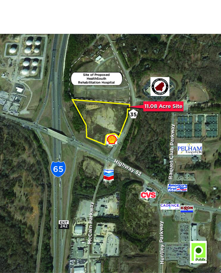
501 Highway 35, Pelham, AL 35124
NEARBY LISTINGS FOR SALE OR LEASE
Property Detail
501 Highway 35
Birmingham-Hoover, AL
The Grande Vista
13-6-24-1-001-020-001
COM SE COR SEC 24 N3091.67 TO POB CONT N122.36 E17.3 TO W ROW HWY 35 N104.67 W728.73 WLY171.49 SW69.31 TO E ROW I-65 SE AL
Commercialacreage
Shelby
X
Alabama
01117C0218E
4.08 AC
2023
I-65 Corr/S Shelby County
2023
Birmingham
030315
DEMOGRAPHICS near 501 Highway 35
1 Mile
3 Mile
5 Mile
2024 Total Population
2,927
31,164
68,598
2029 Population
3,169
33,592
74,453
Pop Growth 2024-2029
+ 8.27%
+ 7.79%
+ 8.54%
Average Age
40
40
39
2024 Total Households
1,204
11,780
25,226
HH Growth 2024-2029
+ 8.47%
+ 7.97%
+ 8.64%
Median Household Inc
$82,491
$82,758
$86,799
Avg Household Size
2.40
2.60
2.70
2024 Avg HH Vehicles
2.00
2.00
2.00
Median Home Value
$252,611
$225,551
$247,238
Median Year Built
2000
1993
1994
Nearby Places
- Restaurants
- Banks
- Shops
- Fitness
- Groceries
PUBLIC TRANSPORTATION
AIRPORT
Birmingham-Shuttlesworth International
DRIVE
WALK
Distance
Birmingham-Shuttlesworth International
34 min
26.7 mi
Freight Ports
Port of Mobile
DRIVE
WALK
Distance
Port of Mobile
260 min
240.0 mi
SALE & LEASE HISTORY
LISTING DATE
SALE/LEASE

Jun 21, 2018
For Sale
Nearby Properties
Address
Land Use
TOTAL SIZE
Lot Size
Zoning
Address
Land Use
TOTAL SIZE
Lot Size
Zoning
442,000 SF
36.44 AC
Address
Land Use
TOTAL SIZE
Lot Size
Zoning
12,200 SF
28.77 AC
Address
Land Use
TOTAL SIZE
Lot Size
Zoning
2,199 SF
23 AC
Address
Land Use
TOTAL SIZE
Lot Size
Zoning
2,792 SF
15 AC
Address
Land Use
TOTAL SIZE
Lot Size
Zoning
10,500 SF
21 AC
Address
Land Use
TOTAL SIZE
Lot Size
Zoning
230,053 SF
23 AC
Address
Land Use
TOTAL SIZE
Lot Size
Zoning
18,781 SF
12.09 AC
Address
Land Use
TOTAL SIZE
Lot Size
Zoning
118,303 SF
22.89 AC
Address
Land Use
TOTAL SIZE
Lot Size
Zoning
6,050 SF
623 AC
Address
Land Use
TOTAL SIZE
Lot Size
Zoning
268,750 SF
9.93 AC
Address
Land Use
TOTAL SIZE
Lot Size
Zoning
59,909 SF
13.70 AC
Address
Land Use
TOTAL SIZE
Lot Size
Zoning
114,082 SF
11 AC
Address
Land Use
TOTAL SIZE
Lot Size
Zoning
43,419 SF
7.81 AC
Address
Land Use
TOTAL SIZE
Lot Size
Zoning
132,698 SF
9.75 AC
Address
Land Use
TOTAL SIZE
Lot Size
Zoning
Address
Land Use
TOTAL SIZE
Lot Size
Zoning
23,633 SF
8.50 AC
Address
Land Use
TOTAL SIZE
Lot Size
Zoning
2,826 SF
74.16 AC
Address
Land Use
TOTAL SIZE
Lot Size
Zoning
20,680 SF
6.60 AC
Address
Land Use
TOTAL SIZE
Lot Size
Zoning
Address
Land Use
TOTAL SIZE
Lot Size
Zoning
18,363 SF
11.40 AC
Address
Land Use
TOTAL SIZE
Lot Size
Zoning
96,118 SF
3.74 AC
Address
Land Use
TOTAL SIZE
Lot Size
Zoning
73,327 SF
9.76 AC
Address
Land Use
TOTAL SIZE
Lot Size
Zoning
630 SF
480 AC
Address
Land Use
TOTAL SIZE
Lot Size
Zoning
46,031 SF
9.86 AC
Address
Land Use
TOTAL SIZE
Lot Size
Zoning
9,996 SF
6.15 AC
Address
Land Use
TOTAL SIZE
Lot Size
Zoning
85,743 SF
38.11 AC
Address
Land Use
TOTAL SIZE
Lot Size
Zoning
50,000 SF
11 AC
Address
Land Use
TOTAL SIZE
Lot Size
Zoning
105,809 SF
5.02 AC
Address
Land Use
TOTAL SIZE
Lot Size
Zoning
10,250 SF
21.16 AC
The World's #1 Commercial Real Estate Marketplace
Connect with us
© 2025 CoStar Group
The information above has been obtained from sources believed reliable. While we do not doubt its accuracy we have not verified it and make no guarantee, warranty or representation about it. It is your responsibility to independently confirm its accuracy and completeness. Any projections, opinions, assumptions, or estimates used are for example only and do not represent the current or future performance of the property. The value of this transaction to you depends on tax and other factors which should be evaluated by your tax, financial, and legal advisors. You and your advisors should conduct a careful, independent investigation of the property to determine to your satisfaction the suitability of the property for your needs.