Property Record
501 S Walnut St, Wilmington, DE 19801
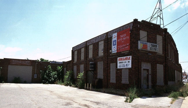

Property Detail
501 S Walnut St
26-050.00-069
BEG ON SWLY SIDE OF HOWARD ST AT 50 FT WIDE & FUTHER LOCATED ALONG SELY SIDE OF HOWARD ST FROM POINT OF INTERSECTION FORMED BY SWLY SIDE OF HOWARD ST
Officebuilding
NEW CASTLE
26W4
Delaware
AE The base floodplain where base flood elevations are provided. AE Zones are now used on new format FIRMs instead of A1-A30 Zones.
a
2025
9.77 AC
2025
Wilmington
001902
Philadelphia
79,922 SF
Philadelphia-Camden-Wilmington, PA-NJ-DE-MD
NEARBY LISTINGS FOR SALE OR LEASE
DEMOGRAPHICS near 501 S Walnut St
1 mile
3 mile
5 mile
2025 Total Population
21,974
115,008
191,772
2030 Population
22,912
118,825
197,123
Pop Growth 2025-2030
+ 4.27%
+ 3.32%
+ 2.79%
Average Age
36
39
41
2025 Total Households
9,146
47,605
78,458
HH Growth 2025-2030
+ 4.41%
+ 3.47%
+ 2.93%
Median Household Inc
$48,353
$59,269
$70,496
Avg Household Size
2.30
2.30
2.40
2025 Avg HH Vehicles
1.00
1.00
2.00
Median Home Value
$173,837
$238,679
$277,576
Median Year Built
1951
1950
1955
Nearby Places
Map Layers
Map Styles
 Street
 Aerial
Layers
 Traffic
 Biking
Places
Listings with unknown addresses are not visible on the map
- Restaurants
- Banks
- Shops
- Fitness
- Groceries
PUBLIC TRANSPORTATION
COMMUTER RAIL
Wilmington (R2 - Southeastern Pennsylvania Transportation Authority Regional Rail (SEPTA Regional Rail))
Drive
Walk
Distance
Wilmington (R2 - Southeastern Pennsylvania Transportation Authority Regional Rail (SEPTA Regional Rail))
3 min
10 min
0.5 mi
Churchmans Crossing (R2 - Southeastern Pennsylvania Transportation Authority Regional Rail (SEPTA Regional Rail))
Drive
Walk
Distance
Churchmans Crossing (R2 - Southeastern Pennsylvania Transportation Authority Regional Rail (SEPTA Regional Rail))
12 min
8.0 mi
AIRPORT
Philadelphia International
Drive
Walk
Distance
Philadelphia International
34 min
23.7 mi
Freight Ports
Port of Wilmington, RI
Drive
Walk
Distance
Port of Wilmington, RI
8 min
2.6 mi
Nearby Properties
Address
Land Use
TOTAL SIZE
Lot Size
Zoning
Address
Land Use
TOTAL SIZE
Lot Size
Zoning
202,328 SF
10.98 AC
26R5-C
Address
Land Use
TOTAL SIZE
Lot Size
Zoning
624,255 SF
132.95 AC
SR
Address
Land Use
TOTAL SIZE
Lot Size
Zoning
14,810 SF
16.25 AC
26M-2
Address
Land Use
TOTAL SIZE
Lot Size
Zoning
7,840 SF
3.82 AC
26C-4
Address
Land Use
TOTAL SIZE
Lot Size
Zoning
20,000 SF
1.26 AC
26C-4
Address
Land Use
TOTAL SIZE
Lot Size
Zoning
593,288 SF
20.38 AC
OR
Address
Land Use
TOTAL SIZE
Lot Size
Zoning
679,619 SF
5.91 AC
26R-3
Address
Land Use
TOTAL SIZE
Lot Size
Zoning
410,310 SF
1.27 AC
26R-3
Address
Land Use
TOTAL SIZE
Lot Size
Zoning
160,931 SF
1.02 AC
26C-6
Address
Land Use
TOTAL SIZE
Lot Size
Zoning
2,864 SF
1.02 AC
26C-4
Address
Land Use
TOTAL SIZE
Lot Size
Zoning
8,025 SF
177.81 AC
26M-2
Address
Land Use
TOTAL SIZE
Lot Size
Zoning
116,042 SF
108.83 AC
SR
Address
Land Use
TOTAL SIZE
Lot Size
Zoning
406,158 SF
1.29 AC
26C-4
Address
Land Use
TOTAL SIZE
Lot Size
Zoning
105.88 AC
26M-2
Address
Land Use
TOTAL SIZE
Lot Size
Zoning
240,000 SF
0.79 AC
26R5-C
Address
Land Use
TOTAL SIZE
Lot Size
Zoning
43,918 SF
1.49 AC
26C-4
Address
Land Use
TOTAL SIZE
Lot Size
Zoning
61,928 SF
128.88 AC
HI
Address
Land Use
TOTAL SIZE
Lot Size
Zoning
332,844 SF
2.15 AC
26C-4
Address
Land Use
TOTAL SIZE
Lot Size
Zoning
258,984 SF
0.80 AC
26C-3
Address
Land Use
TOTAL SIZE
Lot Size
Zoning
38,140 SF
1.15 AC
26C-4
Address
Land Use
TOTAL SIZE
Lot Size
Zoning
27,330 SF
0.80 AC
26C-4
Address
Land Use
TOTAL SIZE
Lot Size
Zoning
43,325 SF
2.69 AC
26C-4
Address
Land Use
TOTAL SIZE
Lot Size
Zoning
12,500 SF
2.05 AC
26W4
Address
Land Use
TOTAL SIZE
Lot Size
Zoning
301,712 SF
0.92 AC
26C-4
Address
Land Use
TOTAL SIZE
Lot Size
Zoning
234,457 SF
18.18 AC
26R-3
Address
Land Use
TOTAL SIZE
Lot Size
Zoning
472,000 SF
1.05 AC
26C-4
Address
Land Use
TOTAL SIZE
Lot Size
Zoning
45,956 SF
1.05 AC
26C-4
Address
Land Use
TOTAL SIZE
Lot Size
Zoning
16,002 SF
16.91 AC
CR
Address
Land Use
TOTAL SIZE
Lot Size
Zoning
411,000 SF
1 AC
26C-4
Address
Land Use
TOTAL SIZE
Lot Size
Zoning
311,493 SF
26C-4
The World's #1 Commercial Real Estate Marketplace
Connect with us
© 2026 CoStar Group
The information above has been obtained from sources believed reliable. While we do not doubt its accuracy we have not verified it and make no guarantee, warranty or representation about it. It is your responsibility to independently confirm its accuracy and completeness. Any projections, opinions, assumptions, or estimates used are for example only and do not represent the current or future performance of the property. The value of this transaction to you depends on tax and other factors which should be evaluated by your tax, financial, and legal advisors. You and your advisors should conduct a careful, independent investigation of the property to determine to your satisfaction the suitability of the property for your needs.