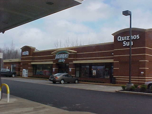
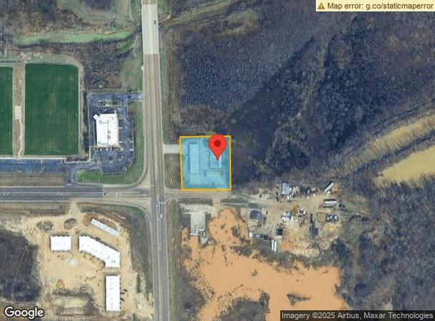
Property Record
5028 Highway 305 N, Olive Branch, MS 38654
NEARBY LISTINGS FOR SALE OR LEASE
-
-
View all Olive Branch listings for sale on LoopNet.com
Property Detail
5028 Highway 305 N
Memphis, TN-MS-AR
Fulmer Comm S/D
2062032100000100
FULMER COMM S/D LOT 1
Realpropertynec
DeSoto
AE
Mississippi
28033C0112H
1
2024
1.23 AC
2024
Olive Branch
070721
Memphis
5,605 SF
DEMOGRAPHICS near 5028 Highway 305 N
1 Mile
3 Mile
5 Mile
2024 Total Population
2,973
29,038
60,375
2029 Population
3,242
31,681
65,044
Pop Growth 2024-2029
+ 9.05%
+ 9.10%
+ 7.73%
Average Age
41
38
39
2024 Total Households
1,024
10,467
21,519
HH Growth 2024-2029
+ 9.08%
+ 9.13%
+ 7.65%
Median Household Inc
$102,552
$79,902
$82,549
Avg Household Size
2.90
2.70
2.80
2024 Avg HH Vehicles
3.00
2.00
2.00
Median Home Value
$260,516
$241,274
$249,494
Median Year Built
1997
1997
1998
Nearby Places
- Restaurants
- Banks
- Shops
- Fitness
- Groceries
PUBLIC TRANSPORTATION
AIRPORT
Memphis International
DRIVE
WALK
Distance
Memphis International
20 min
14.2 mi
Freight Ports
Port of Shreveport
DRIVE
WALK
Distance
Port of Shreveport
425 min
388.0 mi
Nearby Properties
Address
Land Use
TOTAL SIZE
Lot Size
Zoning
Address
Land Use
TOTAL SIZE
Lot Size
Zoning
996,105 SF
60.30 AC
PUD
Address
Land Use
TOTAL SIZE
Lot Size
Zoning
865,146 SF
72.19 AC
M-1
Address
Land Use
TOTAL SIZE
Lot Size
Zoning
865,433 SF
54.55 AC
M-1
Address
Land Use
TOTAL SIZE
Lot Size
Zoning
1,085,489 SF
57.74 AC
PB
Address
Land Use
TOTAL SIZE
Lot Size
Zoning
693,896 SF
47.15 AC
M-1
Address
Land Use
TOTAL SIZE
Lot Size
Zoning
395,779 SF
122.03 AC
M-1
Address
Land Use
TOTAL SIZE
Lot Size
Zoning
28.41 AC
PB
Address
Land Use
TOTAL SIZE
Lot Size
Zoning
447,551 SF
32.34 AC
M-1
Address
Land Use
TOTAL SIZE
Lot Size
Zoning
27,669 SF
34.27 AC
R-4
Address
Land Use
TOTAL SIZE
Lot Size
Zoning
22.08 AC
PB
Address
Land Use
TOTAL SIZE
Lot Size
Zoning
10,155 SF
26.43 AC
R-4
Address
Land Use
TOTAL SIZE
Lot Size
Zoning
301,773 SF
19.98 AC
M-2
Address
Land Use
TOTAL SIZE
Lot Size
Zoning
13,554 SF
15.32 AC
PUD
Address
Land Use
TOTAL SIZE
Lot Size
Zoning
329,828 SF
21.64 AC
M-1
Address
Land Use
TOTAL SIZE
Lot Size
Zoning
250,772 SF
13.72 AC
M-1
Address
Land Use
TOTAL SIZE
Lot Size
Zoning
259,668 SF
14.02 AC
M-1
Address
Land Use
TOTAL SIZE
Lot Size
Zoning
222,790 SF
19.07 AC
M-1
Address
Land Use
TOTAL SIZE
Lot Size
Zoning
11,097 SF
13.39 AC
PUD
Address
Land Use
TOTAL SIZE
Lot Size
Zoning
197,886 SF
18.49 AC
C-4
Address
Land Use
TOTAL SIZE
Lot Size
Zoning
218,688 SF
14.52 AC
M-1
Address
Land Use
TOTAL SIZE
Lot Size
Zoning
11.29 AC
M-1
Address
Land Use
TOTAL SIZE
Lot Size
Zoning
145,074 SF
15.87 AC
C-4
Address
Land Use
TOTAL SIZE
Lot Size
Zoning
44,445 SF
44 AC
C-3
Address
Land Use
TOTAL SIZE
Lot Size
Zoning
12,770 SF
Address
Land Use
TOTAL SIZE
Lot Size
Zoning
113,421 SF
12.93 AC
PUD
Address
Land Use
TOTAL SIZE
Lot Size
Zoning
160,731 SF
23.89 AC
M-2
Address
Land Use
TOTAL SIZE
Lot Size
Zoning
72,099 SF
3.97 AC
C-4
Address
Land Use
TOTAL SIZE
Lot Size
Zoning
114,085 SF
15.81 AC
C-4
Address
Land Use
TOTAL SIZE
Lot Size
Zoning
78,000 SF
9.97 AC
M-1
Address
Land Use
TOTAL SIZE
Lot Size
Zoning
96,508 SF
11.11 AC
M-1
The World's #1 Commercial Real Estate Marketplace
Connect with us
© 2025 CoStar Group
The information above has been obtained from sources believed reliable. While we do not doubt its accuracy we have not verified it and make no guarantee, warranty or representation about it. It is your responsibility to independently confirm its accuracy and completeness. Any projections, opinions, assumptions, or estimates used are for example only and do not represent the current or future performance of the property. The value of this transaction to you depends on tax and other factors which should be evaluated by your tax, financial, and legal advisors. You and your advisors should conduct a careful, independent investigation of the property to determine to your satisfaction the suitability of the property for your needs.