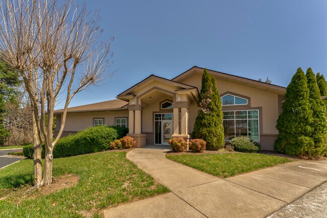
Property Record
505 E Parker Rd, Morganton, NC 28655


NEARBY LISTINGS FOR SALE OR LEASE
Property Detail
505 E Parker Rd
54617
Parker Rd
Realpropertynec
505 E PARKER RD MORGANTON, NC 28655
X
Burke
3710271300J
North Carolina
2025
1.73 AC
2025
Burke County
020802
Charlotte
5,831 SF
Hickory-Lenoir-Morganton, NC
DEMOGRAPHICS near 505 E Parker Rd
1 Mile
3 Mile
5 Mile
2024 Total Population
1,717
20,341
35,767
2029 Population
1,743
20,453
35,987
Pop Growth 2024-2029
+ 1.51%
+ 0.55%
+ 0.62%
Average Age
46
43
44
2024 Total Households
738
8,008
14,257
HH Growth 2024-2029
+ 1.63%
+ 0.60%
+ 0.65%
Median Household Inc
$47,937
$48,817
$52,846
Avg Household Size
2.20
2.30
2.30
2024 Avg HH Vehicles
2.00
2.00
2.00
Median Home Value
$198,396
$174,648
$174,225
Median Year Built
1982
1973
1975
Nearby Places
Map Layers
Map Styles
 Street
 Aerial
- Restaurants
- Banks
- Shops
- Fitness
- Groceries
SALE & LEASE HISTORY
LISTING DATE
SALE/LEASE

Sep 24, 2016
For Sale
Oct 18, 2016
For Sale
May 22, 2019
For Lease
May 21, 2019
For Sale
Mar 02, 2022
For Lease
Jun 20, 2024
For Lease
Jun 01, 2020
For Sale
Jul 11, 2022
For Sale
Feb 03, 2020
For Lease
Nearby Properties
Address
Land Use
TOTAL SIZE
Lot Size
Zoning
Address
Land Use
TOTAL SIZE
Lot Size
Zoning
STATE INST
Address
Land Use
TOTAL SIZE
Lot Size
Zoning
80,043 SF
72.72 AC
HIGH INTEN
Address
Land Use
TOTAL SIZE
Lot Size
Zoning
89,004 SF
STATE INST
Address
Land Use
TOTAL SIZE
Lot Size
Zoning
32,074 SF
HIGH INTEN
Address
Land Use
TOTAL SIZE
Lot Size
Zoning
87,530 SF
HIGH INTEN
Address
Land Use
TOTAL SIZE
Lot Size
Zoning
6,912 SF
24.27 AC
HIGH INTEN
Address
Land Use
TOTAL SIZE
Lot Size
Zoning
31,227 SF
RESIDENTIA
Address
Land Use
TOTAL SIZE
Lot Size
Zoning
MEDIUM INT
Address
Land Use
TOTAL SIZE
Lot Size
Zoning
2,176 SF
23.80 AC
RESIDENTIA
Address
Land Use
TOTAL SIZE
Lot Size
Zoning
HIGH INTEN
Address
Land Use
TOTAL SIZE
Lot Size
Zoning
23,970 SF
33.98 AC
CONDITIONA
Address
Land Use
TOTAL SIZE
Lot Size
Zoning
185,929 SF
32.01 AC
CONDITIONA
Address
Land Use
TOTAL SIZE
Lot Size
Zoning
37,366 SF
22.36 AC
HIGH INTEN
Address
Land Use
TOTAL SIZE
Lot Size
Zoning
250,292 SF
53.11 AC
EXCLUSIVE
Address
Land Use
TOTAL SIZE
Lot Size
Zoning
2,160 SF
12.81 AC
MEDIUM INT
Address
Land Use
TOTAL SIZE
Lot Size
Zoning
6,402 SF
14.14 AC
MEDIUM INT
Address
Land Use
TOTAL SIZE
Lot Size
Zoning
52,977 SF
1.90 AC
MEDIUM INT
Address
Land Use
TOTAL SIZE
Lot Size
Zoning
135,387 SF
9.95 AC
HIGH INTEN
Address
Land Use
TOTAL SIZE
Lot Size
Zoning
32,698 SF
23 AC
MEDIUM INT
Address
Land Use
TOTAL SIZE
Lot Size
Zoning
25,986 SF
16.78 AC
HIGH INTEN
Address
Land Use
TOTAL SIZE
Lot Size
Zoning
26,830 SF
OFFICE INS
Address
Land Use
TOTAL SIZE
Lot Size
Zoning
HIGH INTEN
Address
Land Use
TOTAL SIZE
Lot Size
Zoning
58,998 SF
LOW INTENS
Address
Land Use
TOTAL SIZE
Lot Size
Zoning
71,060 SF
3.10 AC
HIGH INTEN
Address
Land Use
TOTAL SIZE
Lot Size
Zoning
40,056 SF
13.80 AC
CONDITIONA
Address
Land Use
TOTAL SIZE
Lot Size
Zoning
65,175 SF
13.48 AC
CONDITIONA
Address
Land Use
TOTAL SIZE
Lot Size
Zoning
28,405 SF
CENTRAL BU
Address
Land Use
TOTAL SIZE
Lot Size
Zoning
45,568 SF
2.28 AC
HIGH INTEN
Address
Land Use
TOTAL SIZE
Lot Size
Zoning
61,755 SF
HIGH INTEN
Address
Land Use
TOTAL SIZE
Lot Size
Zoning
46,334 SF
CENTRAL BU
The World's #1 Commercial Real Estate Marketplace
Connect with us
© 2026 CoStar Group
The information above has been obtained from sources believed reliable. While we do not doubt its accuracy we have not verified it and make no guarantee, warranty or representation about it. It is your responsibility to independently confirm its accuracy and completeness. Any projections, opinions, assumptions, or estimates used are for example only and do not represent the current or future performance of the property. The value of this transaction to you depends on tax and other factors which should be evaluated by your tax, financial, and legal advisors. You and your advisors should conduct a careful, independent investigation of the property to determine to your satisfaction the suitability of the property for your needs.