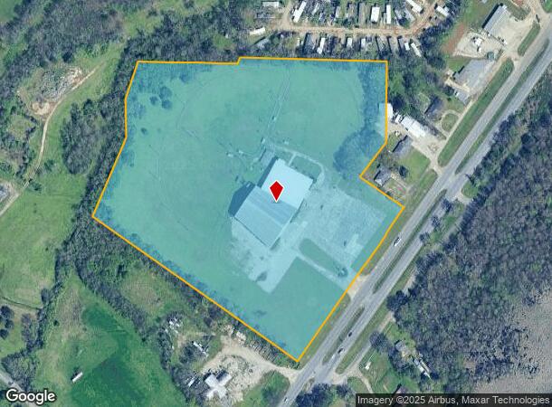
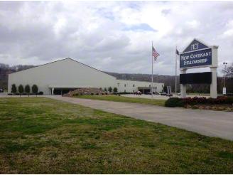
Property Record
5050 Pinson Valley Pkwy, Birmingham, AL 35215

NEARBY LISTINGS FOR SALE OR LEASE
-
-
View all Birmingham listings for sale on LoopNet.com
Property Detail
5050 Pinson Valley Pkwy
13-00-01-3-000-001.001
Pinson Valley Estates
Religious
BEG AT NE COR OF SW1/4 SEC 1 T16S R2W TH S 265 FT TH SW 160 FT TH SE 219 FT TH SW 667.8 FT TH NW 888.5 FT TH NELY 312.2 FT TH NLY 136.5 FT TH NELY 144 FT TH E 360 FT TH NE 21.9 FT TH E ALG S/L CHAMBLEE EST 11/97 510 FT TH S 20 FT TO POB
AE
Jefferson
01073C0237H
Alabama
0
18.84 AC
2024
Fultondale
011210
Birmingham
61,472 SF
Birmingham-Hoover, AL
DEMOGRAPHICS near 5050 Pinson Valley Pkwy
1 Mile
3 Mile
5 Mile
2024 Total Population
2,860
30,909
71,949
2029 Population
2,805
30,312
70,481
Pop Growth 2024-2029
(1.92%)
(1.93%)
(2.04%)
Average Age
34
36
37
2024 Total Households
1,072
11,479
26,930
HH Growth 2024-2029
(1.96%)
(1.98%)
(2.08%)
Median Household Inc
$43,152
$46,038
$51,145
Avg Household Size
2.70
2.60
2.60
2024 Avg HH Vehicles
2.00
2.00
2.00
Median Home Value
$148,714
$149,561
$148,629
Median Year Built
1979
1976
1977
Nearby Places
- Restaurants
- Banks
- Shops
- Fitness
- Groceries
PUBLIC TRANSPORTATION
AIRPORT
Birmingham-Shuttlesworth International
DRIVE
WALK
Distance
Birmingham-Shuttlesworth International
23 min
13.1 mi
Freight Ports
Port of Mobile
DRIVE
WALK
Distance
Port of Mobile
1 min
219.9 mi
Nearby Properties
Address
Land Use
TOTAL SIZE
Lot Size
Zoning
Address
Land Use
TOTAL SIZE
Lot Size
Zoning
623,200 SF
50 AC
CM2
Address
Land Use
TOTAL SIZE
Lot Size
Zoning
218,922 SF
21 AC
CR5
Address
Land Use
TOTAL SIZE
Lot Size
Zoning
192,596 SF
13.79 AC
CR5
Address
Land Use
TOTAL SIZE
Lot Size
Zoning
147,200 SF
7.93 AC
CR5
Address
Land Use
TOTAL SIZE
Lot Size
Zoning
531,808 SF
23.96 AC
I4&A
Address
Land Use
TOTAL SIZE
Lot Size
Zoning
502,302 SF
24.61 AC
I4&A
Address
Land Use
TOTAL SIZE
Lot Size
Zoning
125,252 SF
8.07 AC
R4
Address
Land Use
TOTAL SIZE
Lot Size
Zoning
117,342 SF
36 AC
I
Address
Land Use
TOTAL SIZE
Lot Size
Zoning
116,732 SF
4.06 AC
R-4
Address
Land Use
TOTAL SIZE
Lot Size
Zoning
81,817 SF
9.30 AC
C1
Address
Land Use
TOTAL SIZE
Lot Size
Zoning
80,834 SF
7.13 AC
CR5
Address
Land Use
TOTAL SIZE
Lot Size
Zoning
109,878 SF
10 AC
C1
Address
Land Use
TOTAL SIZE
Lot Size
Zoning
74,159 SF
2.50 AC
INST
Address
Land Use
TOTAL SIZE
Lot Size
Zoning
26,169 SF
71 AC
R2
Address
Land Use
TOTAL SIZE
Lot Size
Zoning
257,988 SF
CM2
Address
Land Use
TOTAL SIZE
Lot Size
Zoning
63,736 SF
11 AC
I
Address
Land Use
TOTAL SIZE
Lot Size
Zoning
84,602 SF
11.20 AC
B2
Address
Land Use
TOTAL SIZE
Lot Size
Zoning
118,041 SF
5.10 AC
C1
Address
Land Use
TOTAL SIZE
Lot Size
Zoning
113,175 SF
21.85 AC
I2
Address
Land Use
TOTAL SIZE
Lot Size
Zoning
158,835 SF
9.50 AC
I-4
Address
Land Use
TOTAL SIZE
Lot Size
Zoning
244,800 SF
CM2
Address
Land Use
TOTAL SIZE
Lot Size
Zoning
80,752 SF
7.86 AC
R4
Address
Land Use
TOTAL SIZE
Lot Size
Zoning
76,000 SF
7.30 AC
M-3
Address
Land Use
TOTAL SIZE
Lot Size
Zoning
106,452 SF
7.40 AC
M-3
Address
Land Use
TOTAL SIZE
Lot Size
Zoning
147,810 SF
13 AC
I4
Address
Land Use
TOTAL SIZE
Lot Size
Zoning
3.56 AC
CR6&
Address
Land Use
TOTAL SIZE
Lot Size
Zoning
84,282 SF
5.57 AC
R4
Address
Land Use
TOTAL SIZE
Lot Size
Zoning
49,384 SF
2.87 AC
CR5
Address
Land Use
TOTAL SIZE
Lot Size
Zoning
50,530 SF
36.76 AC
CM1
The World's #1 Commercial Real Estate Marketplace
Connect with us
© 2025 CoStar Group
The information above has been obtained from sources believed reliable. While we do not doubt its accuracy we have not verified it and make no guarantee, warranty or representation about it. It is your responsibility to independently confirm its accuracy and completeness. Any projections, opinions, assumptions, or estimates used are for example only and do not represent the current or future performance of the property. The value of this transaction to you depends on tax and other factors which should be evaluated by your tax, financial, and legal advisors. You and your advisors should conduct a careful, independent investigation of the property to determine to your satisfaction the suitability of the property for your needs.