Property Record
5050 Yale St, Houston, TX 77018
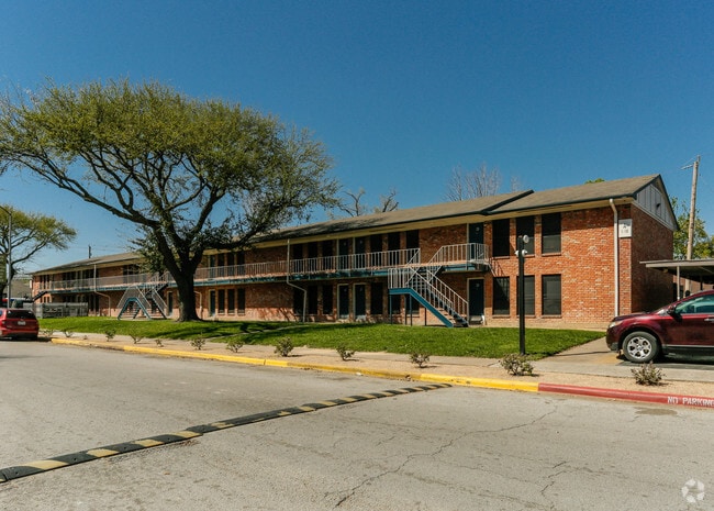

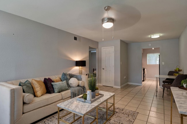

Property Detail
5050 Yale St
0160010000013
TRS 13C 13D 13F 13J & 13K BARKWOOD APTS HALFF
Apartment
HARRIS
AE The base floodplain where base flood elevations are provided. AE Zones are now used on new format FIRMs instead of A1-A30 Zones.
Texas
2024
9.48 AC
2025
Independence Heights
530502
Houston
200,511 SF
Houston-Pasadena-The Woodlands, TX
NEARBY LISTINGS FOR SALE OR LEASE
DEMOGRAPHICS near 5050 Yale St
1 mile
3 mile
5 mile
2025 Total Population
17,894
149,204
395,405
2030 Population
19,436
160,762
425,142
Pop Growth 2025-2030
+ 8.62%
+ 7.75%
+ 7.52%
Average Age
38
37
37
2025 Total Households
6,634
54,942
148,948
HH Growth 2025-2030
+ 8.85%
+ 8.10%
+ 7.94%
Median Household Inc
$48,821
$70,793
$70,410
Avg Household Size
2.60
2.70
2.60
2025 Avg HH Vehicles
2.00
2.00
2.00
Median Home Value
$306,425
$390,900
$364,575
Median Year Built
1968
1971
1976
Nearby Places
Map Layers
Map Styles
 Street
 Aerial
Layers
 Traffic
 Biking
Places
Listings with unknown addresses are not visible on the map
- Restaurants
- Banks
- Shops
- Fitness
- Groceries
PUBLIC TRANSPORTATION
COMMUTER RAIL
Houston (Sunset Limited - Amtrak)
Drive
Walk
Distance
Houston (Sunset Limited - Amtrak)
12 min
6.1 mi
AIRPORT
George Bush Intcntl/Houston
Drive
Walk
Distance
George Bush Intcntl/Houston
21 min
15.0 mi
William P Hobby
Drive
Walk
Distance
William P Hobby
32 min
19.8 mi
Freight Ports
Port of Houston
Drive
Walk
Distance
Port of Houston
24 min
15.1 mi
SALE & LEASE HISTORY
LISTING DATE
SALE/LEASE

Jul 10, 2018
For Sale
Nearby Properties
Address
Land Use
TOTAL SIZE
Lot Size
Zoning
Address
Land Use
TOTAL SIZE
Lot Size
Zoning
453,456 SF
3.11 AC
Address
Land Use
TOTAL SIZE
Lot Size
Zoning
519,374 SF
6.18 AC
Address
Land Use
TOTAL SIZE
Lot Size
Zoning
563,626 SF
4.71 AC
Address
Land Use
TOTAL SIZE
Lot Size
Zoning
474,326 SF
43.16 AC
Address
Land Use
TOTAL SIZE
Lot Size
Zoning
432,691 SF
3.26 AC
Address
Land Use
TOTAL SIZE
Lot Size
Zoning
261,312 SF
1.81 AC
Address
Land Use
TOTAL SIZE
Lot Size
Zoning
593,265 SF
3.73 AC
Address
Land Use
TOTAL SIZE
Lot Size
Zoning
594,105 SF
43.68 AC
Address
Land Use
TOTAL SIZE
Lot Size
Zoning
379,725 SF
2.84 AC
Address
Land Use
TOTAL SIZE
Lot Size
Zoning
587,156 SF
4.40 AC
Address
Land Use
TOTAL SIZE
Lot Size
Zoning
440,577 SF
4.13 AC
Address
Land Use
TOTAL SIZE
Lot Size
Zoning
443,228 SF
3.15 AC
Address
Land Use
TOTAL SIZE
Lot Size
Zoning
87,179 SF
4.13 AC
Address
Land Use
TOTAL SIZE
Lot Size
Zoning
322,880 SF
2.61 AC
Address
Land Use
TOTAL SIZE
Lot Size
Zoning
402,433 SF
2.77 AC
Address
Land Use
TOTAL SIZE
Lot Size
Zoning
263,475 SF
7.90 AC
Address
Land Use
TOTAL SIZE
Lot Size
Zoning
280,241 SF
1.90 AC
Address
Land Use
TOTAL SIZE
Lot Size
Zoning
279,452 SF
5.69 AC
Address
Land Use
TOTAL SIZE
Lot Size
Zoning
198,770 SF
2.10 AC
Address
Land Use
TOTAL SIZE
Lot Size
Zoning
228,804 SF
3.28 AC
Address
Land Use
TOTAL SIZE
Lot Size
Zoning
235,535 SF
1.71 AC
Address
Land Use
TOTAL SIZE
Lot Size
Zoning
276,332 SF
6.05 AC
Address
Land Use
TOTAL SIZE
Lot Size
Zoning
545,628 SF
19.41 AC
Address
Land Use
TOTAL SIZE
Lot Size
Zoning
531,786 SF
17.60 AC
Address
Land Use
TOTAL SIZE
Lot Size
Zoning
197,696 SF
3.06 AC
Address
Land Use
TOTAL SIZE
Lot Size
Zoning
194,990 SF
16.36 AC
Address
Land Use
TOTAL SIZE
Lot Size
Zoning
213,548 SF
16.98 AC
Address
Land Use
TOTAL SIZE
Lot Size
Zoning
160,849 SF
2.14 AC
Address
Land Use
TOTAL SIZE
Lot Size
Zoning
105,268 SF
7.26 AC
Address
Land Use
TOTAL SIZE
Lot Size
Zoning
211,564 SF
1.20 AC
The World's #1 Commercial Real Estate Marketplace
Connect with us
© 2026 CoStar Group
The information above has been obtained from sources believed reliable. While we do not doubt its accuracy we have not verified it and make no guarantee, warranty or representation about it. It is your responsibility to independently confirm its accuracy and completeness. Any projections, opinions, assumptions, or estimates used are for example only and do not represent the current or future performance of the property. The value of this transaction to you depends on tax and other factors which should be evaluated by your tax, financial, and legal advisors. You and your advisors should conduct a careful, independent investigation of the property to determine to your satisfaction the suitability of the property for your needs.