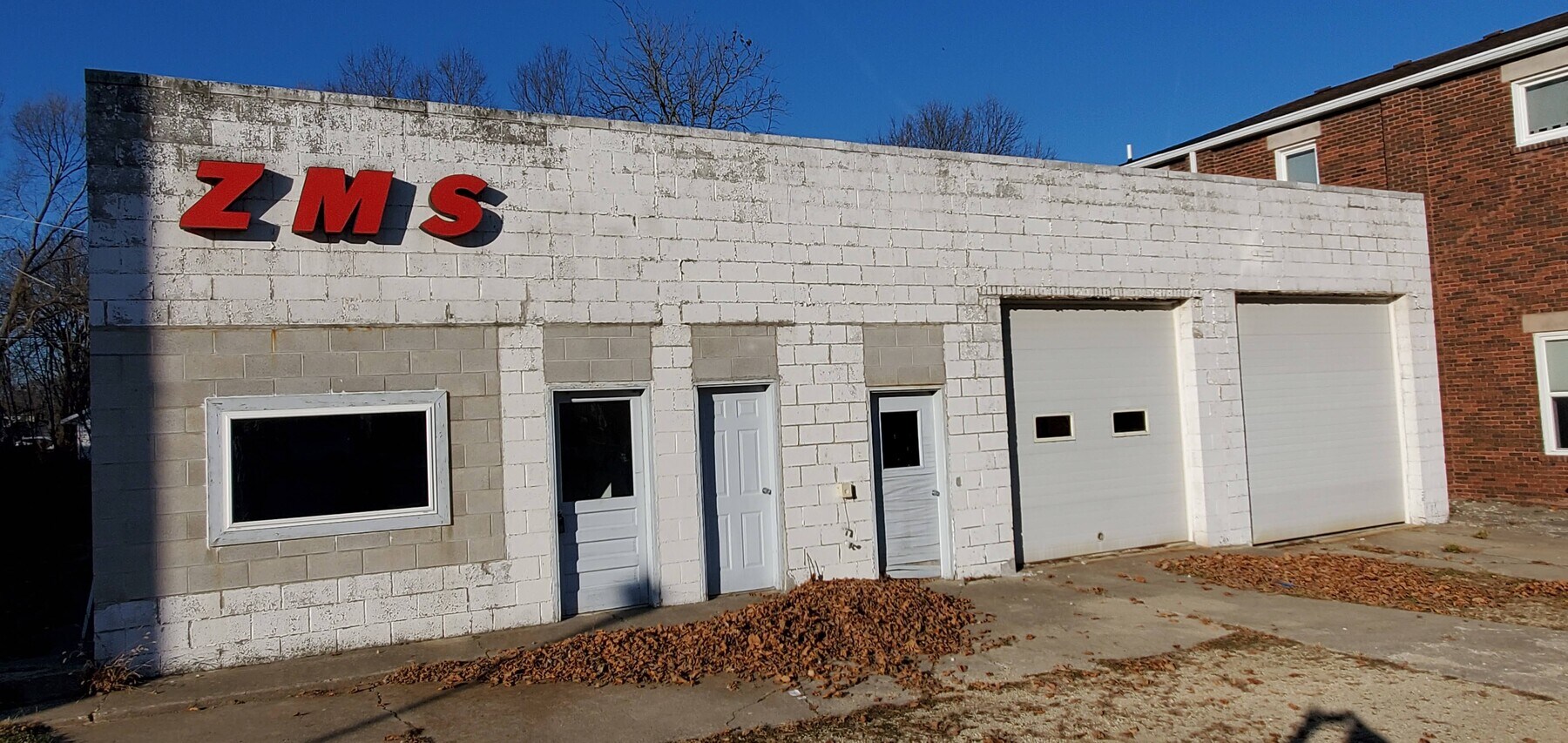
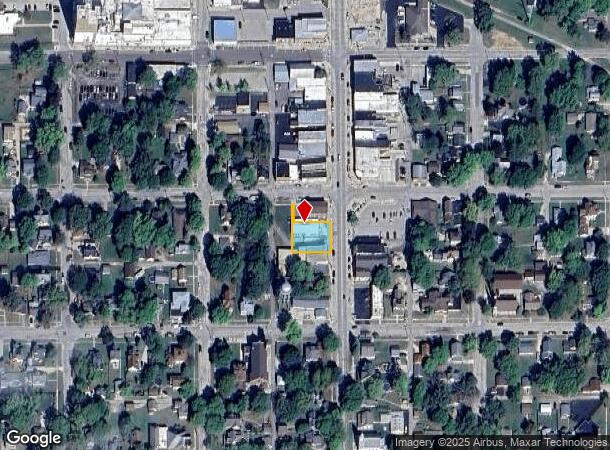
Property Record
507 Main St, Pecatonica, IL 61063
NEARBY LISTINGS FOR SALE OR LEASE
-
-
View all Pecatonica listings for sale on LoopNet.com
Property Detail
507 Main St
Rockford, IL
Original Plat
09-29-282-015
PLAT OF PECATONICA PT W1/2 SEC 28 & PTE1/2 SEC 29-27-10 (EXC N 46 FT E 105.18 FT LT 1) E 112.68 FT LOTS 1 & 2 BLK12
Commercialnec
Winnebago
X
Illinois
17201C0203E
1
2022
0.23 AC
2022
I-39 Corr/Winnebago Cnty
004300
Chicago
3,204 SF
DEMOGRAPHICS near 507 Main St
1 Mile
3 Mile
5 Mile
2024 Total Population
1,904
2,471
4,319
2029 Population
1,842
2,374
4,109
Pop Growth 2024-2029
(3.26%)
(3.93%)
(4.86%)
Average Age
41
41
42
2024 Total Households
798
1,028
1,718
HH Growth 2024-2029
(3.26%)
(3.89%)
(4.77%)
Median Household Inc
$66,536
$70,730
$84,654
Avg Household Size
2.40
2.40
2.50
2024 Avg HH Vehicles
2.00
2.00
2.00
Median Home Value
$133,793
$141,558
$161,374
Median Year Built
1955
1958
1970
Nearby Places
- Restaurants
- Banks
- Shops
- Fitness
- Groceries
PUBLIC TRANSPORTATION
AIRPORT
Chicago/Rockford International
DRIVE
WALK
Distance
Chicago/Rockford International
32 min
21.2 mi
Freight Ports
Port Milwaukee
DRIVE
WALK
Distance
Port Milwaukee
131 min
102.6 mi
SALE & LEASE HISTORY
LISTING DATE
SALE/LEASE

Dec 04, 2020
For Sale
Nearby Properties
Address
Land Use
TOTAL SIZE
Lot Size
Zoning
Address
Land Use
TOTAL SIZE
Lot Size
Zoning
2.50 AC
Address
Land Use
TOTAL SIZE
Lot Size
Zoning
3.54 AC
Address
Land Use
TOTAL SIZE
Lot Size
Zoning
1.53 AC
Address
Land Use
TOTAL SIZE
Lot Size
Zoning
6,500 SF
36.02 AC
AG
Address
Land Use
TOTAL SIZE
Lot Size
Zoning
1,638 SF
13.05 AC
AG
Address
Land Use
TOTAL SIZE
Lot Size
Zoning
8,415 SF
0.32 AC
Address
Land Use
TOTAL SIZE
Lot Size
Zoning
5.97 AC
CG
Address
Land Use
TOTAL SIZE
Lot Size
Zoning
4,930 SF
40 AC
AG
Address
Land Use
TOTAL SIZE
Lot Size
Zoning
1.50 AC
Address
Land Use
TOTAL SIZE
Lot Size
Zoning
4.33 AC
Address
Land Use
TOTAL SIZE
Lot Size
Zoning
3.59 AC
CG
Address
Land Use
TOTAL SIZE
Lot Size
Zoning
2,400 SF
1.10 AC
Address
Land Use
TOTAL SIZE
Lot Size
Zoning
4,060 SF
24.08 AC
AG
Address
Land Use
TOTAL SIZE
Lot Size
Zoning
3,981 SF
40.01 AC
AG
Address
Land Use
TOTAL SIZE
Lot Size
Zoning
7,880 SF
0.38 AC
Address
Land Use
TOTAL SIZE
Lot Size
Zoning
49.32 AC
Address
Land Use
TOTAL SIZE
Lot Size
Zoning
2,900 SF
39.05 AC
AG
Address
Land Use
TOTAL SIZE
Lot Size
Zoning
4,304 SF
18.20 AC
AG
Address
Land Use
TOTAL SIZE
Lot Size
Zoning
225.16 AC
Address
Land Use
TOTAL SIZE
Lot Size
Zoning
2,300 SF
15.50 AC
AG
Address
Land Use
TOTAL SIZE
Lot Size
Zoning
3,300 SF
57.50 AC
AG
Address
Land Use
TOTAL SIZE
Lot Size
Zoning
6,676 SF
2.80 AC
CC
Address
Land Use
TOTAL SIZE
Lot Size
Zoning
2,514 SF
115 AC
AG
Address
Land Use
TOTAL SIZE
Lot Size
Zoning
10 AC
AG
Address
Land Use
TOTAL SIZE
Lot Size
Zoning
3.23 AC
Address
Land Use
TOTAL SIZE
Lot Size
Zoning
3,010 SF
80 AC
Address
Land Use
TOTAL SIZE
Lot Size
Zoning
163.64 AC
Address
Land Use
TOTAL SIZE
Lot Size
Zoning
2,000 SF
10 AC
AG1
Address
Land Use
TOTAL SIZE
Lot Size
Zoning
192.70 AC
Address
Land Use
TOTAL SIZE
Lot Size
Zoning
1,746 SF
10.37 AC
RA
The World's #1 Commercial Real Estate Marketplace
Connect with us
© 2025 CoStar Group
The information above has been obtained from sources believed reliable. While we do not doubt its accuracy we have not verified it and make no guarantee, warranty or representation about it. It is your responsibility to independently confirm its accuracy and completeness. Any projections, opinions, assumptions, or estimates used are for example only and do not represent the current or future performance of the property. The value of this transaction to you depends on tax and other factors which should be evaluated by your tax, financial, and legal advisors. You and your advisors should conduct a careful, independent investigation of the property to determine to your satisfaction the suitability of the property for your needs.