Property Record
507 W Cardella Rd, Merced, CA 95348
NEARBY LISTINGS FOR SALE OR LEASE
Property Detail
507 W Cardella Rd
Merced, CA
Bar Mer Tr
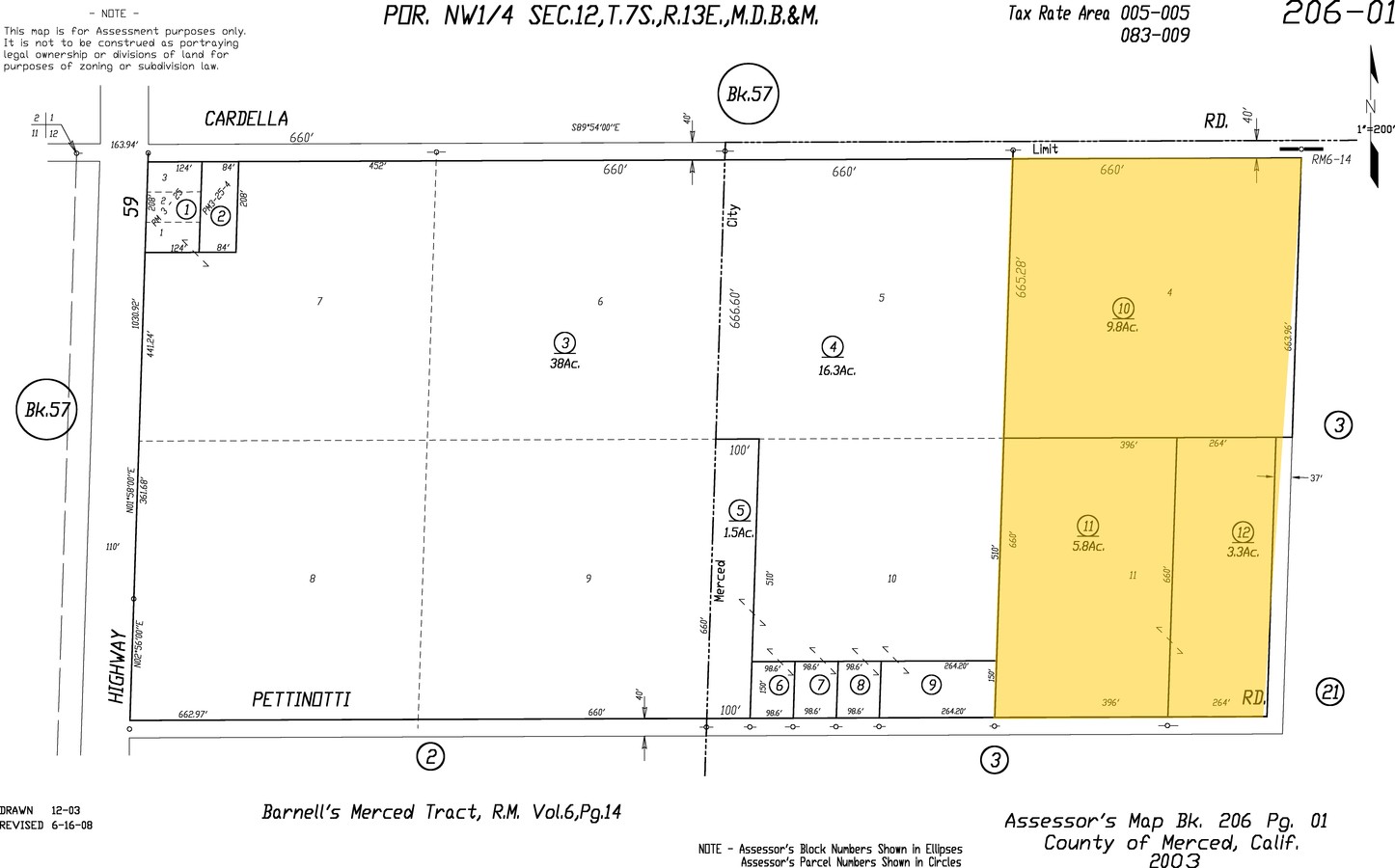
206-010-010
BAR MER TR POR LOT 11 12/7/13
Recreationalacreage
Merced
X
California
06047C0426G
11
2024
9.80 AC
2024
Suburban Merced
001008
Fresno
1,704 SF
DEMOGRAPHICS near 507 W Cardella Rd
1 Mile
3 Mile
5 Mile
2024 Total Population
7,807
60,147
121,005
2029 Population
8,556
65,256
130,991
Pop Growth 2024-2029
+ 9.59%
+ 8.49%
+ 8.25%
Average Age
33
35
35
2024 Total Households
2,130
19,461
37,491
HH Growth 2024-2029
+ 9.62%
+ 8.60%
+ 8.38%
Median Household Inc
$103,620
$55,866
$51,910
Avg Household Size
3.40
2.90
3.10
2024 Avg HH Vehicles
3.00
2.00
2.00
Median Home Value
$372,386
$338,865
$337,280
Median Year Built
2002
1986
1984
Nearby Places
- Restaurants
- Banks
- Shops
- Fitness
- Groceries
PUBLIC TRANSPORTATION
COMMUTER RAIL
Merced (San Joaquins - Amtrak)
DRIVE
WALK
Distance
Merced (San Joaquins - Amtrak)
9 min
5.1 mi
Freight Ports
Port of Stockton
DRIVE
WALK
Distance
Port of Stockton
91 min
73.6 mi
Nearby Properties
Address
Land Use
TOTAL SIZE
Lot Size
Zoning
Address
Land Use
TOTAL SIZE
Lot Size
Zoning
17.50 AC
CO
Address
Land Use
TOTAL SIZE
Lot Size
Zoning
7.80 AC
IL
Address
Land Use
TOTAL SIZE
Lot Size
Zoning
12.35 AC
CG
Address
Land Use
TOTAL SIZE
Lot Size
Zoning
4.87 AC
PD
Address
Land Use
TOTAL SIZE
Lot Size
Zoning
2.90 AC
CO
Address
Land Use
TOTAL SIZE
Lot Size
Zoning
3.50 AC
R4
Address
Land Use
TOTAL SIZE
Lot Size
Zoning
27.32 AC
PD
Address
Land Use
TOTAL SIZE
Lot Size
Zoning
42.55 AC
Address
Land Use
TOTAL SIZE
Lot Size
Zoning
28.36 AC
Address
Land Use
TOTAL SIZE
Lot Size
Zoning
1.70 AC
CO
Address
Land Use
TOTAL SIZE
Lot Size
Zoning
3.90 AC
PD
Address
Land Use
TOTAL SIZE
Lot Size
Zoning
2 AC
PD
Address
Land Use
TOTAL SIZE
Lot Size
Zoning
11.80 AC
PD
Address
Land Use
TOTAL SIZE
Lot Size
Zoning
10 AC
PD
Address
Land Use
TOTAL SIZE
Lot Size
Zoning
1.80 AC
Address
Land Use
TOTAL SIZE
Lot Size
Zoning
9.30 AC
IH
Address
Land Use
TOTAL SIZE
Lot Size
Zoning
4.50 AC
R4
Address
Land Use
TOTAL SIZE
Lot Size
Zoning
10.30 AC
CT
Address
Land Use
TOTAL SIZE
Lot Size
Zoning
0.36 AC
PD
Address
Land Use
TOTAL SIZE
Lot Size
Zoning
0.34 AC
CC
Address
Land Use
TOTAL SIZE
Lot Size
Zoning
8,014 SF
5.92 AC
RPD
Address
Land Use
TOTAL SIZE
Lot Size
Zoning
40 AC
IH
Address
Land Use
TOTAL SIZE
Lot Size
Zoning
5.90 AC
RPD
Address
Land Use
TOTAL SIZE
Lot Size
Zoning
3.66 AC
RPD
Address
Land Use
TOTAL SIZE
Lot Size
Zoning
5.91 AC
PD
Address
Land Use
TOTAL SIZE
Lot Size
Zoning
5.40 AC
PD
Address
Land Use
TOTAL SIZE
Lot Size
Zoning
3,058 SF
4 AC
PD
Address
Land Use
TOTAL SIZE
Lot Size
Zoning
5.30 AC
PD
Address
Land Use
TOTAL SIZE
Lot Size
Zoning
2.97 AC
Address
Land Use
TOTAL SIZE
Lot Size
Zoning
942 SF
428 AC
A1
The World's #1 Commercial Real Estate Marketplace
Connect with us
© 2025 CoStar Group
The information above has been obtained from sources believed reliable. While we do not doubt its accuracy we have not verified it and make no guarantee, warranty or representation about it. It is your responsibility to independently confirm its accuracy and completeness. Any projections, opinions, assumptions, or estimates used are for example only and do not represent the current or future performance of the property. The value of this transaction to you depends on tax and other factors which should be evaluated by your tax, financial, and legal advisors. You and your advisors should conduct a careful, independent investigation of the property to determine to your satisfaction the suitability of the property for your needs.