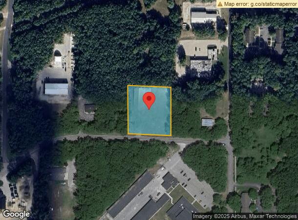
Property Record
5070 Industrial Park Rd, Montague, MI 49437

NEARBY LISTINGS FOR SALE OR LEASE
-
-
View all Montague listings for sale on LoopNet.com
Property Detail
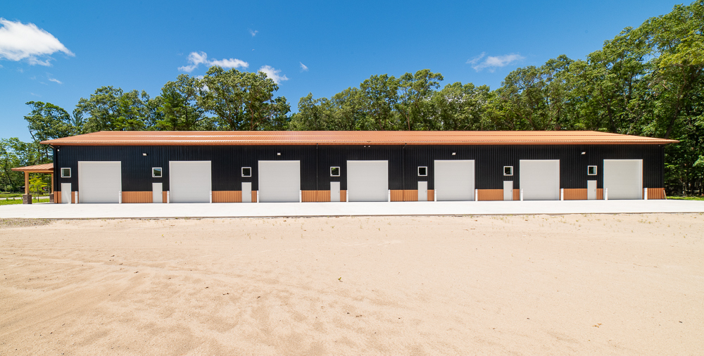
5070 Industrial Park Rd
Muskegon, MI
Montague Industrial Park Subdivision
21-305-000-0016-00
MONTAGUE CITY INDUSTRIAL PARK SUBD LOT 16
Commercialnec
Muskegon
X
Michigan
26121C0038E
16
0
1.59 AC
2024
Northern Muskegon County
003800
West Michigan
21,000 SF
DEMOGRAPHICS near 5070 Industrial Park Rd
1 Mile
3 Mile
5 Mile
2024 Total Population
1,980
8,025
13,719
2029 Population
2,026
8,146
13,992
Pop Growth 2024-2029
+ 2.32%
+ 1.51%
+ 1.99%
Average Age
45
44
44
2024 Total Households
868
3,387
5,638
HH Growth 2024-2029
+ 2.42%
+ 1.51%
+ 2.02%
Median Household Inc
$64,636
$63,963
$64,521
Avg Household Size
2.30
2.30
2.40
2024 Avg HH Vehicles
2.00
2.00
2.00
Median Home Value
$189,166
$188,022
$192,100
Median Year Built
1967
1970
1973
Nearby Places
- Restaurants
- Banks
- Shops
- Fitness
- Groceries
SALE & LEASE HISTORY
LISTING DATE
SALE/LEASE

Sep 04, 2024
For Sale
May 23, 2024
For Sale
Nearby Properties
Address
Land Use
TOTAL SIZE
Lot Size
Zoning
Address
Land Use
TOTAL SIZE
Lot Size
Zoning
611,964 SF
127.38 AC
M-2 GEN
Address
Land Use
TOTAL SIZE
Lot Size
Zoning
104,000 SF
Address
Land Use
TOTAL SIZE
Lot Size
Zoning
126,901 SF
30.35 AC
B COM
Address
Land Use
TOTAL SIZE
Lot Size
Zoning
222.62 AC
LDR
Address
Land Use
TOTAL SIZE
Lot Size
Zoning
117,661 SF
14.70 AC
M-1 LIM
Address
Land Use
TOTAL SIZE
Lot Size
Zoning
355,574 SF
38.02 AC
M-1 IND
Address
Land Use
TOTAL SIZE
Lot Size
Zoning
70,092 SF
14.17 AC
C-COM
Address
Land Use
TOTAL SIZE
Lot Size
Zoning
38.94 AC
LMSD
Address
Land Use
TOTAL SIZE
Lot Size
Zoning
183,166 SF
12.83 AC
M-2 GEN
Address
Land Use
TOTAL SIZE
Lot Size
Zoning
32,945 SF
14.70 AC
Address
Land Use
TOTAL SIZE
Lot Size
Zoning
75,575 SF
5 AC
M-1 LIM
Address
Land Use
TOTAL SIZE
Lot Size
Zoning
72,461 SF
7.69 AC
M-1 IND
Address
Land Use
TOTAL SIZE
Lot Size
Zoning
41,187 SF
1.50 AC
B COM
Address
Land Use
TOTAL SIZE
Lot Size
Zoning
37,041 SF
12.18 AC
R-1 RES
Address
Land Use
TOTAL SIZE
Lot Size
Zoning
27,205 SF
3.68 AC
B COM
Address
Land Use
TOTAL SIZE
Lot Size
Zoning
11,923 SF
812.04 AC
FR
Address
Land Use
TOTAL SIZE
Lot Size
Zoning
3,332 SF
12.28 AC
RM MULT
Address
Land Use
TOTAL SIZE
Lot Size
Zoning
214 AC
Address
Land Use
TOTAL SIZE
Lot Size
Zoning
35,320 SF
10.88 AC
R-3 RES
Address
Land Use
TOTAL SIZE
Lot Size
Zoning
37,368 SF
2.80 AC
B COM
Address
Land Use
TOTAL SIZE
Lot Size
Zoning
38,180 SF
3.12 AC
LR-LAKE
Address
Land Use
TOTAL SIZE
Lot Size
Zoning
78,066 SF
15.24 AC
B COM
Address
Land Use
TOTAL SIZE
Lot Size
Zoning
34,825 SF
6.77 AC
M-1 LIM
Address
Land Use
TOTAL SIZE
Lot Size
Zoning
29,262 SF
2.74 AC
C-1 COM
Address
Land Use
TOTAL SIZE
Lot Size
Zoning
2,359 SF
2.32 AC
LR-LAKE
Address
Land Use
TOTAL SIZE
Lot Size
Zoning
15,846 SF
1.54 AC
B-1 GEN
Address
Land Use
TOTAL SIZE
Lot Size
Zoning
41,969 SF
3.26 AC
R-3 RES
Address
Land Use
TOTAL SIZE
Lot Size
Zoning
39,696 SF
3.09 AC
R-3 RES
Address
Land Use
TOTAL SIZE
Lot Size
Zoning
14,418 SF
2.50 AC
MI LIMI
Address
Land Use
TOTAL SIZE
Lot Size
Zoning
9,487 SF
2.66 AC
M-1 LIM
The World's #1 Commercial Real Estate Marketplace
Connect with us
© 2025 CoStar Group
The information above has been obtained from sources believed reliable. While we do not doubt its accuracy we have not verified it and make no guarantee, warranty or representation about it. It is your responsibility to independently confirm its accuracy and completeness. Any projections, opinions, assumptions, or estimates used are for example only and do not represent the current or future performance of the property. The value of this transaction to you depends on tax and other factors which should be evaluated by your tax, financial, and legal advisors. You and your advisors should conduct a careful, independent investigation of the property to determine to your satisfaction the suitability of the property for your needs.