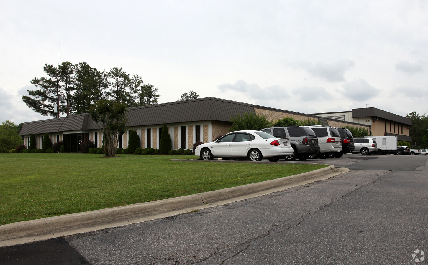
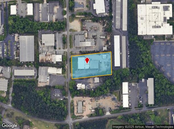
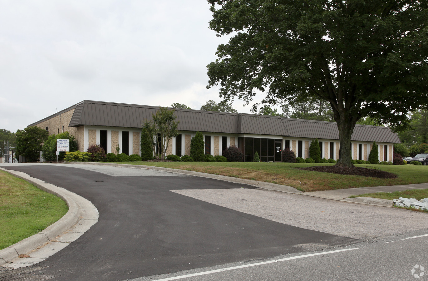
Property Record
5102 Neal Rd, Durham, NC 27705
NEARBY LISTINGS FOR SALE OR LEASE
Property Detail
5102 Neal Rd
175239
Survey For Bryant Durham Eletric
Miscellaneous
PROP-COOK NEAL/TR#02 DBA BRYANT DURHAM PL:000000-000000
X
Durham
3720080300L
North Carolina
2023
2.55 AC
2024
South Durham
001713
Raleigh/Durham
22,394 SF
Durham-Chapel Hill, NC
DEMOGRAPHICS near 5102 Neal Rd
1 Mile
3 Mile
5 Mile
2024 Total Population
4,846
34,418
116,670
2029 Population
4,998
35,595
121,069
Pop Growth 2024-2029
+ 3.14%
+ 3.42%
+ 3.77%
Average Age
42
40
38
2024 Total Households
2,173
16,131
50,076
HH Growth 2024-2029
+ 3.27%
+ 3.89%
+ 4.25%
Median Household Inc
$108,852
$63,310
$64,277
Avg Household Size
2.20
2.10
2.10
2024 Avg HH Vehicles
2.00
2.00
2.00
Median Home Value
$337,923
$369,743
$358,211
Median Year Built
1984
1987
1984
Nearby Places
- Restaurants
- Banks
- Shops
- Fitness
- Groceries
PUBLIC TRANSPORTATION
COMMUTER RAIL
Durham Amtrak Station (Carolinian - Amtrak, Piedmont - Amtrak)
DRIVE
WALK
Distance
Durham Amtrak Station (Carolinian - Amtrak, Piedmont - Amtrak)
11 min
5.8 mi
AIRPORT
Raleigh-Durham International
DRIVE
WALK
Distance
Raleigh-Durham International
30 min
19.9 mi
Freight Ports
Virginia Port Authority - Richmond
DRIVE
WALK
Distance
Virginia Port Authority - Richmond
172 min
150.2 mi
Nearby Properties
Address
Land Use
TOTAL SIZE
Lot Size
Zoning
Address
Land Use
TOTAL SIZE
Lot Size
Zoning
597,213 SF
676.09 AC
UC
Address
Land Use
TOTAL SIZE
Lot Size
Zoning
497,148 SF
2.53 AC
MU(D)
Address
Land Use
TOTAL SIZE
Lot Size
Zoning
812,903 SF
9.31 AC
UC
Address
Land Use
TOTAL SIZE
Lot Size
Zoning
664,061 SF
99.64 AC
PDR 2.000
Address
Land Use
TOTAL SIZE
Lot Size
Zoning
416,469 SF
3.85 AC
MU(D)
Address
Land Use
TOTAL SIZE
Lot Size
Zoning
441,868 SF
6.11 AC
MU(D)
Address
Land Use
TOTAL SIZE
Lot Size
Zoning
90,416 SF
3.87 AC
CD-S1
Address
Land Use
TOTAL SIZE
Lot Size
Zoning
132,520 SF
15.94 AC
RU-M(D)
Address
Land Use
TOTAL SIZE
Lot Size
Zoning
9,126 SF
20.02 AC
RU-M
Address
Land Use
TOTAL SIZE
Lot Size
Zoning
12,440 SF
36.51 AC
PDR 2.000
Address
Land Use
TOTAL SIZE
Lot Size
Zoning
12,236 SF
43.44 AC
RU-M
Address
Land Use
TOTAL SIZE
Lot Size
Zoning
236,319 SF
17.04 AC
UC(D)
Address
Land Use
TOTAL SIZE
Lot Size
Zoning
297,910 SF
39.63 AC
RS-20
Address
Land Use
TOTAL SIZE
Lot Size
Zoning
234,754 SF
4.85 AC
UC
Address
Land Use
TOTAL SIZE
Lot Size
Zoning
12,468 SF
13.33 AC
RU-M(D)
Address
Land Use
TOTAL SIZE
Lot Size
Zoning
1.19 AC
MU
Address
Land Use
TOTAL SIZE
Lot Size
Zoning
153,300 SF
0.99 AC
MU(D)
Address
Land Use
TOTAL SIZE
Lot Size
Zoning
208,472 SF
1.41 AC
MU(D)
Address
Land Use
TOTAL SIZE
Lot Size
Zoning
6,822 SF
24.64 AC
PDR 2.000
Address
Land Use
TOTAL SIZE
Lot Size
Zoning
3.20 AC
CD-S1
Address
Land Use
TOTAL SIZE
Lot Size
Zoning
36,380 SF
4.02 AC
MU(D)
Address
Land Use
TOTAL SIZE
Lot Size
Zoning
9,318 SF
19.27 AC
RS-M
Address
Land Use
TOTAL SIZE
Lot Size
Zoning
13,432 SF
21.46 AC
RU-M
Address
Land Use
TOTAL SIZE
Lot Size
Zoning
828,002 SF
2.24 AC
UC
Address
Land Use
TOTAL SIZE
Lot Size
Zoning
233,478 SF
10.60 AC
OI
Address
Land Use
TOTAL SIZE
Lot Size
Zoning
20,508 SF
15.82 AC
RS-M
Address
Land Use
TOTAL SIZE
Lot Size
Zoning
67,353 SF
5.06 AC
CG(D)
Address
Land Use
TOTAL SIZE
Lot Size
Zoning
130,550 SF
4.07 AC
I
Address
Land Use
TOTAL SIZE
Lot Size
Zoning
79,947 SF
0.90 AC
MU(D)
Address
Land Use
TOTAL SIZE
Lot Size
Zoning
6,936 SF
11.42 AC
PDR 2.000
The World's #1 Commercial Real Estate Marketplace
Connect with us
© 2025 CoStar Group
The information above has been obtained from sources believed reliable. While we do not doubt its accuracy we have not verified it and make no guarantee, warranty or representation about it. It is your responsibility to independently confirm its accuracy and completeness. Any projections, opinions, assumptions, or estimates used are for example only and do not represent the current or future performance of the property. The value of this transaction to you depends on tax and other factors which should be evaluated by your tax, financial, and legal advisors. You and your advisors should conduct a careful, independent investigation of the property to determine to your satisfaction the suitability of the property for your needs.