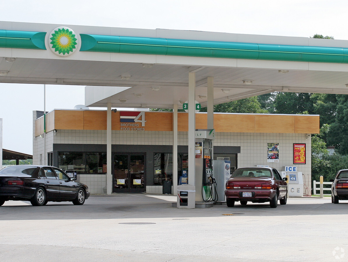
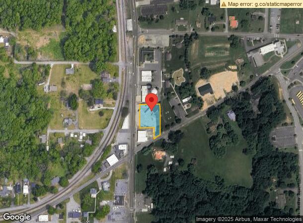
Property Record
5115 Main St, Walkertown, NC 27051
NEARBY LISTINGS FOR SALE OR LEASE
Property Detail
5115 Main St
Winston-Salem, NC
Bp Oil
6858-94-8906
BP OIL LO003 BL2152 BU1
Storebuilding
Forsyth
X
North Carolina
3710685800J
3
2023
0.50 AC
2023
NE Forsyth County
003105
Greensboro/Winston-Salem
2,240 SF
DEMOGRAPHICS near 5115 Main St
1 Mile
3 Mile
5 Mile
2024 Total Population
2,392
14,882
44,033
2029 Population
2,497
15,494
45,827
Pop Growth 2024-2029
+ 4.39%
+ 4.11%
+ 4.07%
Average Age
42
42
42
2024 Total Households
955
5,912
17,305
HH Growth 2024-2029
+ 4.40%
+ 4.13%
+ 4.06%
Median Household Inc
$63,306
$68,639
$65,313
Avg Household Size
2.40
2.50
2.50
2024 Avg HH Vehicles
2.00
2.00
2.00
Median Home Value
$203,347
$189,322
$201,985
Median Year Built
1990
1984
1983
Nearby Places
- Restaurants
- Banks
- Shops
- Fitness
- Groceries
PUBLIC TRANSPORTATION
AIRPORT
Piedmont Triad International
DRIVE
WALK
Distance
Piedmont Triad International
32 min
17.6 mi
Freight Ports
Virginia Port Authority - Richmond
DRIVE
WALK
Distance
Virginia Port Authority - Richmond
258 min
221.2 mi
Nearby Properties
Address
Land Use
TOTAL SIZE
Lot Size
Zoning
Address
Land Use
TOTAL SIZE
Lot Size
Zoning
73,908 SF
14.40 AC
GB-S
Address
Land Use
TOTAL SIZE
Lot Size
Zoning
77,879 SF
9.56 AC
GB-S
Address
Land Use
TOTAL SIZE
Lot Size
Zoning
82,081 SF
14.47 AC
HB-S,LO-S
Address
Land Use
TOTAL SIZE
Lot Size
Zoning
77,092 SF
20.91 AC
RS9
Address
Land Use
TOTAL SIZE
Lot Size
Zoning
113,016 SF
6.45 AC
IP
Address
Land Use
TOTAL SIZE
Lot Size
Zoning
107,609 SF
11.53 AC
HB-S
Address
Land Use
TOTAL SIZE
Lot Size
Zoning
11,500 SF
139.75 AC
GI,RS9
Address
Land Use
TOTAL SIZE
Lot Size
Zoning
31,830 SF
3.49 AC
IP
Address
Land Use
TOTAL SIZE
Lot Size
Zoning
6,436 SF
23.85 AC
RM8-S
Address
Land Use
TOTAL SIZE
Lot Size
Zoning
60,639 SF
14.81 AC
IP
Address
Land Use
TOTAL SIZE
Lot Size
Zoning
23,429 SF
3.16 AC
IP
Address
Land Use
TOTAL SIZE
Lot Size
Zoning
41,743 SF
8.51 AC
RM18-S
Address
Land Use
TOTAL SIZE
Lot Size
Zoning
24,720 SF
10.50 AC
IP
Address
Land Use
TOTAL SIZE
Lot Size
Zoning
22,053 SF
5.28 AC
HB-S
Address
Land Use
TOTAL SIZE
Lot Size
Zoning
48,400 SF
8.59 AC
HB-S
Address
Land Use
TOTAL SIZE
Lot Size
Zoning
30,030 SF
9.76 AC
IP,RS9
Address
Land Use
TOTAL SIZE
Lot Size
Zoning
13,101 SF
1.73 AC
HB-S
Address
Land Use
TOTAL SIZE
Lot Size
Zoning
18,076 SF
3.60 AC
RS20
Address
Land Use
TOTAL SIZE
Lot Size
Zoning
14,424 SF
1.88 AC
HB,LB,RS20
Address
Land Use
TOTAL SIZE
Lot Size
Zoning
15,702 SF
2.55 AC
LB-S
Address
Land Use
TOTAL SIZE
Lot Size
Zoning
34,540 SF
13.16 AC
IP
Address
Land Use
TOTAL SIZE
Lot Size
Zoning
5,663 SF
1.40 AC
HB-S
Address
Land Use
TOTAL SIZE
Lot Size
Zoning
13,910 SF
3.33 AC
LO-S,PB-S
Address
Land Use
TOTAL SIZE
Lot Size
Zoning
11,664 SF
2.43 AC
IP
Address
Land Use
TOTAL SIZE
Lot Size
Zoning
5,279 SF
1.29 AC
HB-S
Address
Land Use
TOTAL SIZE
Lot Size
Zoning
12,315 SF
1.09 AC
HB-S
Address
Land Use
TOTAL SIZE
Lot Size
Zoning
16,929 SF
2.56 AC
RS40
Address
Land Use
TOTAL SIZE
Lot Size
Zoning
15,306 SF
3.56 AC
IP,RS20
Address
Land Use
TOTAL SIZE
Lot Size
Zoning
30,435 SF
7.07 AC
HB
Address
Land Use
TOTAL SIZE
Lot Size
Zoning
3,541 SF
1.13 AC
HB-S
The World's #1 Commercial Real Estate Marketplace
Connect with us
© 2025 CoStar Group
The information above has been obtained from sources believed reliable. While we do not doubt its accuracy we have not verified it and make no guarantee, warranty or representation about it. It is your responsibility to independently confirm its accuracy and completeness. Any projections, opinions, assumptions, or estimates used are for example only and do not represent the current or future performance of the property. The value of this transaction to you depends on tax and other factors which should be evaluated by your tax, financial, and legal advisors. You and your advisors should conduct a careful, independent investigation of the property to determine to your satisfaction the suitability of the property for your needs.