Property Record
5118 Fairfield Rd, Columbia, SC 29203

NEARBY LISTINGS FOR SALE OR LEASE
Property Detail
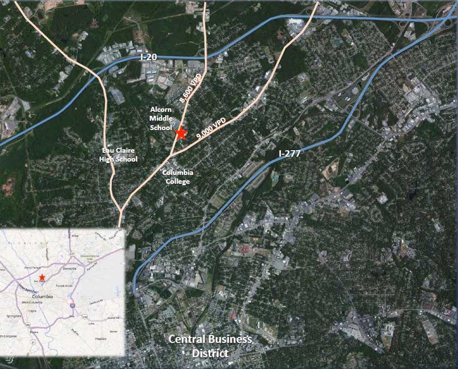
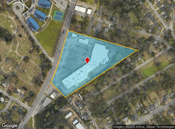
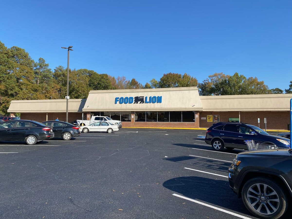
5118 Fairfield Rd
11701-02-19
Alta Acsm Land Title Survey
Commercialnec
PARCEL A 619.8X792X950.6X234.8 #SU NORTHWAY PLAZA #PR W/S
X
Richland
45079C0242L
South Carolina
2024
8.02 AC
2023
North Columbia
010600
Columbia
74,478 SF
Columbia, SC
DEMOGRAPHICS near 5118 Fairfield Rd
1 Mile
3 Mile
5 Mile
2024 Total Population
8,084
51,019
153,553
2029 Population
8,298
52,246
156,984
Pop Growth 2024-2029
+ 2.65%
+ 2.40%
+ 2.23%
Average Age
38
40
37
2024 Total Households
3,599
22,093
65,539
HH Growth 2024-2029
+ 2.75%
+ 2.46%
+ 2.41%
Median Household Inc
$25,462
$36,857
$43,494
Avg Household Size
2.20
2.20
2.10
2024 Avg HH Vehicles
1.00
1.00
1.00
Median Home Value
$106,522
$136,727
$190,875
Median Year Built
1966
1965
1969
Nearby Places
- Restaurants
- Banks
- Shops
- Fitness
- Groceries
PUBLIC TRANSPORTATION
COMMUTER RAIL
Columbia Amtrak Station (Silver Star - Amtrak)
DRIVE
WALK
Distance
Columbia Amtrak Station (Silver Star - Amtrak)
11 min
4.9 mi
AIRPORT
Columbia Metro
DRIVE
WALK
Distance
Columbia Metro
29 min
14.4 mi
Freight Ports
North Charleston Terminal
DRIVE
WALK
Distance
North Charleston Terminal
129 min
110.7 mi
SALE & LEASE HISTORY
LISTING DATE
SALE/LEASE

Nov 09, 2023
For Sale
Nearby Properties
Address
Land Use
TOTAL SIZE
Lot Size
Zoning
Address
Land Use
TOTAL SIZE
Lot Size
Zoning
20,434 SF
17.20 AC
C-1
Address
Land Use
TOTAL SIZE
Lot Size
Zoning
501,365 SF
13.28 AC
O-I
Address
Land Use
TOTAL SIZE
Lot Size
Zoning
319,842 SF
0.78 AC
DAC
Address
Land Use
TOTAL SIZE
Lot Size
Zoning
100 SF
19.24 AC
C-1
Address
Land Use
TOTAL SIZE
Lot Size
Zoning
278,912 SF
23.24 AC
RM-HD
Address
Land Use
TOTAL SIZE
Lot Size
Zoning
237,885 SF
20.76 AC
RM-2
Address
Land Use
TOTAL SIZE
Lot Size
Zoning
96,189 SF
2.22 AC
C-1
Address
Land Use
TOTAL SIZE
Lot Size
Zoning
55.91 AC
M-1
Address
Land Use
TOTAL SIZE
Lot Size
Zoning
100 SF
156.42 AC
RSF-2
Address
Land Use
TOTAL SIZE
Lot Size
Zoning
34,393 SF
2.96 AC
M-1
Address
Land Use
TOTAL SIZE
Lot Size
Zoning
115,734 SF
0.98 AC
C-1
Address
Land Use
TOTAL SIZE
Lot Size
Zoning
100 SF
7.45 AC
RM-1
Address
Land Use
TOTAL SIZE
Lot Size
Zoning
21,580 SF
1.44 AC
RAC
Address
Land Use
TOTAL SIZE
Lot Size
Zoning
67,200 SF
1.72 AC
C-1
Address
Land Use
TOTAL SIZE
Lot Size
Zoning
100 SF
44.73 AC
C-1
Address
Land Use
TOTAL SIZE
Lot Size
Zoning
90,430 SF
0.42 AC
C-1
Address
Land Use
TOTAL SIZE
Lot Size
Zoning
129,017 SF
14.70 AC
PDD
Address
Land Use
TOTAL SIZE
Lot Size
Zoning
65,058 SF
3.54 AC
C-1
Address
Land Use
TOTAL SIZE
Lot Size
Zoning
103,405 SF
0.38 AC
C-3
Address
Land Use
TOTAL SIZE
Lot Size
Zoning
100 SF
4.44 AC
C-3
Address
Land Use
TOTAL SIZE
Lot Size
Zoning
85,065 SF
2.43 AC
C-1
Address
Land Use
TOTAL SIZE
Lot Size
Zoning
42,735 SF
2.12 AC
C-1
Address
Land Use
TOTAL SIZE
Lot Size
Zoning
14,360 SF
4.61 AC
C-1
Address
Land Use
TOTAL SIZE
Lot Size
Zoning
12,694 SF
3.68 AC
DAC
Address
Land Use
TOTAL SIZE
Lot Size
Zoning
7.99 AC
C-1
Address
Land Use
TOTAL SIZE
Lot Size
Zoning
134,400 SF
5.85 AC
RG-2
Address
Land Use
TOTAL SIZE
Lot Size
Zoning
199,962 SF
40.13 AC
RG-1
Address
Land Use
TOTAL SIZE
Lot Size
Zoning
100 SF
4.45 AC
RG-2
Address
Land Use
TOTAL SIZE
Lot Size
Zoning
91,543 SF
4.73 AC
C-1
Address
Land Use
TOTAL SIZE
Lot Size
Zoning
96,248 SF
5.97 AC
RM-2
The World's #1 Commercial Real Estate Marketplace
Connect with us
© 2025 CoStar Group
The information above has been obtained from sources believed reliable. While we do not doubt its accuracy we have not verified it and make no guarantee, warranty or representation about it. It is your responsibility to independently confirm its accuracy and completeness. Any projections, opinions, assumptions, or estimates used are for example only and do not represent the current or future performance of the property. The value of this transaction to you depends on tax and other factors which should be evaluated by your tax, financial, and legal advisors. You and your advisors should conduct a careful, independent investigation of the property to determine to your satisfaction the suitability of the property for your needs.