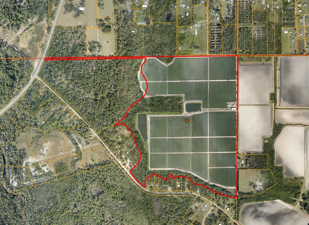
Property Record
5135 Bonita Dr, Wimauma, FL 33598
NEARBY LISTINGS FOR SALE OR LEASE
Property Detail
5135 Bonita Dr
Tampa-St. Petersburg-Clearwater, FL
Unplatted
U-30-32-20-ZZZ-000003-26200.0
COM NE COR FOR POB S 00 DEG 11 MIN 40 SEC W 3157.65 FT MOL TO CENTERLINE OF CREEK THN MEANDER NELY ELY NWLY NLY ALG CENTERLINE OF CREEK TO A POINT S 89 DEG 10 MIN W 2194.61 FT FROM POB THN N 89 DEG 10 MIN E 842.97 FT THN N 00 DEG 28 MIN W 1285.29 FT
Miscellaneous
Hillsborough
AE
Florida
12081C0065F
26200
2023
88.34 AC
2023
Eastern Outlying
013914
Tampa/St Petersburg
60 SF
DEMOGRAPHICS near 5135 Bonita Dr
1 Mile
3 Mile
5 Mile
2024 Total Population
2,100
23,026
53,710
2029 Population
2,447
26,068
60,371
Pop Growth 2024-2029
+ 16.52%
+ 13.21%
+ 12.40%
Average Age
34
54
54
2024 Total Households
548
10,299
23,404
HH Growth 2024-2029
+ 16.79%
+ 12.87%
+ 12.48%
Median Household Inc
$65,077
$55,477
$58,223
Avg Household Size
3.40
2.10
2.10
2024 Avg HH Vehicles
3.00
2.00
2.00
Median Home Value
$369,999
$258,615
$243,448
Median Year Built
2010
2001
1998
Nearby Places
- Restaurants
- Banks
- Shops
- Fitness
- Groceries
PUBLIC TRANSPORTATION
AIRPORT
Sarasota/Bradenton International
DRIVE
WALK
Distance
Sarasota/Bradenton International
52 min
31.4 mi
Tampa International
DRIVE
WALK
Distance
Tampa International
56 min
35.5 mi
St Pete-Clearwater International
DRIVE
WALK
Distance
St Pete-Clearwater International
70 min
47.9 mi
Freight Ports
Port Manatee
DRIVE
WALK
Distance
Port Manatee
32 min
19.1 mi
Nearby Properties
Address
Land Use
TOTAL SIZE
Lot Size
Zoning
Address
Land Use
TOTAL SIZE
Lot Size
Zoning
365,695 SF
17.84 AC
PD-MU
Address
Land Use
TOTAL SIZE
Lot Size
Zoning
295,588 SF
10.80 AC
PD-MU
Address
Land Use
TOTAL SIZE
Lot Size
Zoning
4,979 SF
1,483.49 AC
PD
Address
Land Use
TOTAL SIZE
Lot Size
Zoning
211,729 SF
33.11 AC
PD
Address
Land Use
TOTAL SIZE
Lot Size
Zoning
75,710 SF
10.24 AC
PD
Address
Land Use
TOTAL SIZE
Lot Size
Zoning
62,648 SF
19.54 AC
AR
Address
Land Use
TOTAL SIZE
Lot Size
Zoning
52,776 SF
213.10 AC
PD-MU
Address
Land Use
TOTAL SIZE
Lot Size
Zoning
191.29 AC
PD
Address
Land Use
TOTAL SIZE
Lot Size
Zoning
139.83 AC
PD
Address
Land Use
TOTAL SIZE
Lot Size
Zoning
53,580 SF
12.07 AC
PD-MU
Address
Land Use
TOTAL SIZE
Lot Size
Zoning
49,600 SF
4.54 AC
PD
Address
Land Use
TOTAL SIZE
Lot Size
Zoning
675.65 AC
A
Address
Land Use
TOTAL SIZE
Lot Size
Zoning
38,547 SF
26.88 AC
AS-1
Address
Land Use
TOTAL SIZE
Lot Size
Zoning
173.41 AC
PD
Address
Land Use
TOTAL SIZE
Lot Size
Zoning
4,564 SF
15.53 AC
PD
Address
Land Use
TOTAL SIZE
Lot Size
Zoning
17,616 SF
2.19 AC
CG
Address
Land Use
TOTAL SIZE
Lot Size
Zoning
624 SF
359.68 AC
AR
Address
Land Use
TOTAL SIZE
Lot Size
Zoning
27,124 SF
2.99 AC
PD-MU
Address
Land Use
TOTAL SIZE
Lot Size
Zoning
1,620 SF
224.25 AC
PD
Address
Land Use
TOTAL SIZE
Lot Size
Zoning
26,274 SF
1.42 AC
PD-MU
Address
Land Use
TOTAL SIZE
Lot Size
Zoning
17.42 AC
PD
Address
Land Use
TOTAL SIZE
Lot Size
Zoning
56.47 AC
PD
Address
Land Use
TOTAL SIZE
Lot Size
Zoning
414.58 AC
AR
Address
Land Use
TOTAL SIZE
Lot Size
Zoning
291.65 AC
AR
Address
Land Use
TOTAL SIZE
Lot Size
Zoning
20,022 SF
2.29 AC
CG
Address
Land Use
TOTAL SIZE
Lot Size
Zoning
22,733 SF
156.25 AC
PD
Address
Land Use
TOTAL SIZE
Lot Size
Zoning
370.62 AC
AR
Address
Land Use
TOTAL SIZE
Lot Size
Zoning
6,179 SF
1.76 AC
PD
Address
Land Use
TOTAL SIZE
Lot Size
Zoning
15,606 SF
1.54 AC
CG
Address
Land Use
TOTAL SIZE
Lot Size
Zoning
482.92 AC
AM
The World's #1 Commercial Real Estate Marketplace
Connect with us
© 2025 CoStar Group
The information above has been obtained from sources believed reliable. While we do not doubt its accuracy we have not verified it and make no guarantee, warranty or representation about it. It is your responsibility to independently confirm its accuracy and completeness. Any projections, opinions, assumptions, or estimates used are for example only and do not represent the current or future performance of the property. The value of this transaction to you depends on tax and other factors which should be evaluated by your tax, financial, and legal advisors. You and your advisors should conduct a careful, independent investigation of the property to determine to your satisfaction the suitability of the property for your needs.