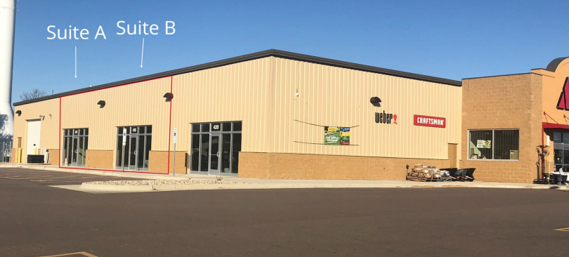
Property Record
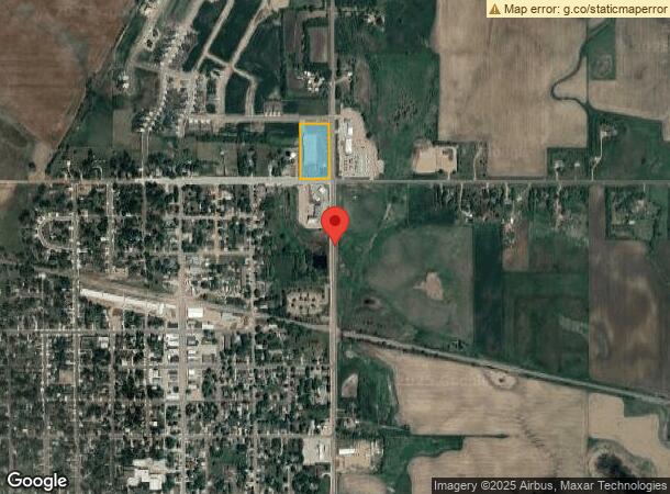
515 N Pine St E, Lennox, SD 57039
NEARBY LISTINGS FOR SALE OR LEASE
-
-
View all Lennox listings for lease on LoopNet.com
Property Detail
515 N Pine St E
Sioux Falls, SD
Sunshine Add
250.79.00.A100
TRACT 1, SUNSHINE ADD, CITY OF LENNOX
Commercialnec
Lincoln
X
South Dakota
46125C0325C
a100
2023
3.91 AC
2023
Sioux Falls
010300
Other Market Areas
DEMOGRAPHICS near 515 N Pine St E
1 Mile
3 Mile
5 Mile
2024 Total Population
2,292
3,021
3,773
2029 Population
2,769
3,641
4,502
Pop Growth 2024-2029
+ 20.81%
+ 20.52%
+ 19.32%
Average Age
41
41
41
2024 Total Households
869
1,129
1,409
HH Growth 2024-2029
+ 21.17%
+ 20.81%
+ 19.59%
Median Household Inc
$64,390
$67,769
$71,497
Avg Household Size
2.50
2.60
2.60
2024 Avg HH Vehicles
2.00
2.00
3.00
Median Home Value
$174,804
$182,848
$194,430
Median Year Built
1973
1973
1972
Nearby Places
- Restaurants
- Banks
- Shops
- Fitness
- Groceries
PUBLIC TRANSPORTATION
AIRPORT
Joe Foss Field
DRIVE
WALK
Distance
Joe Foss Field
44 min
23.7 mi
Freight Ports
Port Milwaukee
DRIVE
WALK
Distance
Port Milwaukee
572 min
523.2 mi
SALE & LEASE HISTORY
LISTING DATE
SALE/LEASE

Nov 02, 2018
For Lease
Nearby Properties
Address
Land Use
TOTAL SIZE
Lot Size
Zoning
Address
Land Use
TOTAL SIZE
Lot Size
Zoning
25.27 AC
MUNICIPALI
Address
Land Use
TOTAL SIZE
Lot Size
Zoning
6.03 AC
MUNICIPALI
Address
Land Use
TOTAL SIZE
Lot Size
Zoning
9.25 AC
MUNICIPALI
Address
Land Use
TOTAL SIZE
Lot Size
Zoning
3.21 AC
MUNICIPALI
Address
Land Use
TOTAL SIZE
Lot Size
Zoning
3.31 AC
MUNICIPALI
Address
Land Use
TOTAL SIZE
Lot Size
Zoning
25.14 AC
MUNICIPALI
Address
Land Use
TOTAL SIZE
Lot Size
Zoning
0.69 AC
MUNICIPALI
Address
Land Use
TOTAL SIZE
Lot Size
Zoning
1.39 AC
MUNICIPALI
Address
Land Use
TOTAL SIZE
Lot Size
Zoning
159.38 AC
A-1 AGRICU
Address
Land Use
TOTAL SIZE
Lot Size
Zoning
81.88 AC
A-1 AGRICU
Address
Land Use
TOTAL SIZE
Lot Size
Zoning
14.64 AC
A-1 AGRICU
Address
Land Use
TOTAL SIZE
Lot Size
Zoning
0.49 AC
MUNICIPALI
Address
Land Use
TOTAL SIZE
Lot Size
Zoning
160.30 AC
A-1 AGRICU
Address
Land Use
TOTAL SIZE
Lot Size
Zoning
141.11 AC
A-1 AGRICU
Address
Land Use
TOTAL SIZE
Lot Size
Zoning
6.84 AC
MUNICIPALI
Address
Land Use
TOTAL SIZE
Lot Size
Zoning
105.24 AC
A-1 AGRICU
Address
Land Use
TOTAL SIZE
Lot Size
Zoning
158.66 AC
A-1 AGRICU
Address
Land Use
TOTAL SIZE
Lot Size
Zoning
76.36 AC
A-1 AGRICU
Address
Land Use
TOTAL SIZE
Lot Size
Zoning
160.68 AC
A-1 AGRICU
Address
Land Use
TOTAL SIZE
Lot Size
Zoning
0.88 AC
MUNICIPALI
Address
Land Use
TOTAL SIZE
Lot Size
Zoning
45.94 AC
A-1 AGRICU
Address
Land Use
TOTAL SIZE
Lot Size
Zoning
61.90 AC
A-1 AGRICU
Address
Land Use
TOTAL SIZE
Lot Size
Zoning
Address
Land Use
TOTAL SIZE
Lot Size
Zoning
0.92 AC
C COMMERCI
Address
Land Use
TOTAL SIZE
Lot Size
Zoning
0.70 AC
MUNICIPALI
Address
Land Use
TOTAL SIZE
Lot Size
Zoning
138.29 AC
A-1 AGRICU
Address
Land Use
TOTAL SIZE
Lot Size
Zoning
0.89 AC
MUNICIPALI
Address
Land Use
TOTAL SIZE
Lot Size
Zoning
0.53 AC
MUNICIPALI
Address
Land Use
TOTAL SIZE
Lot Size
Zoning
5.01 AC
The World's #1 Commercial Real Estate Marketplace
Connect with us
© 2025 CoStar Group
The information above has been obtained from sources believed reliable. While we do not doubt its accuracy we have not verified it and make no guarantee, warranty or representation about it. It is your responsibility to independently confirm its accuracy and completeness. Any projections, opinions, assumptions, or estimates used are for example only and do not represent the current or future performance of the property. The value of this transaction to you depends on tax and other factors which should be evaluated by your tax, financial, and legal advisors. You and your advisors should conduct a careful, independent investigation of the property to determine to your satisfaction the suitability of the property for your needs.