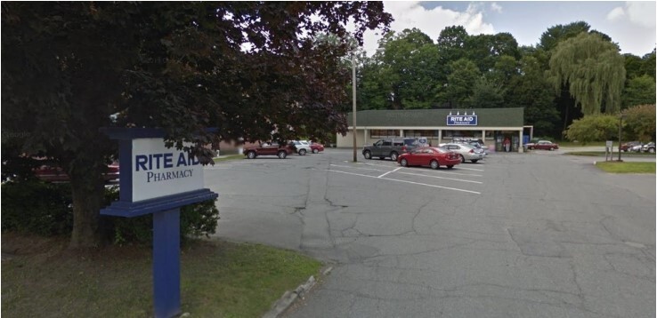
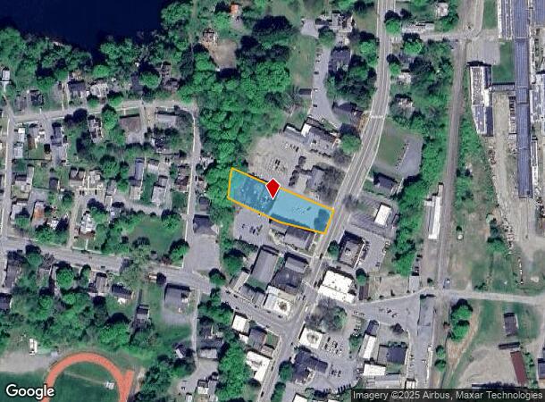
Property Record
52 Main St, Windsor, VT 05089

NEARBY LISTINGS FOR SALE OR LEASE
Property Detail
52 Main St
768-244-12529
BLDG/L
Storesoffices
Windsor
X
Vermont
50027C0632E
0.70 AC
2023
Vermont South Area
2023
Other Market Areas
966000
Claremont-Lebanon, NH-VT
10,500 SF
DEMOGRAPHICS near 52 Main St
1 Mile
3 Mile
5 Mile
2024 Total Population
2,414
4,302
7,711
2029 Population
2,468
4,405
7,861
Pop Growth 2024-2029
+ 2.24%
+ 2.39%
+ 1.95%
Average Age
44
45
46
2024 Total Households
1,078
1,893
3,384
HH Growth 2024-2029
+ 2.13%
+ 2.22%
+ 1.68%
Median Household Inc
$42,628
$52,395
$65,687
Avg Household Size
2.10
2.20
2.20
2024 Avg HH Vehicles
2.00
2.00
2.00
Median Home Value
$156,721
$193,899
$253,046
Median Year Built
1947
1949
1961
Nearby Places
- Restaurants
- Banks
- Shops
- Fitness
- Groceries
PUBLIC TRANSPORTATION
COMMUTER RAIL
Windsor-Mt. Ascutney Amtrak (Vermonter - Amtrak)
DRIVE
WALK
Distance
Windsor-Mt. Ascutney Amtrak (Vermonter - Amtrak)
0 min
2 min
0.2 mi
Claremont Amtrak (Vermonter - Amtrak)
DRIVE
WALK
Distance
Claremont Amtrak (Vermonter - Amtrak)
15 min
9.3 mi
Freight Ports
Albany, NY Port
DRIVE
WALK
Distance
Albany, NY Port
176 min
116.5 mi
SALE & LEASE HISTORY
LISTING DATE
SALE/LEASE

Feb 17, 2022
For Sale
Feb 07, 2022
For Sale
Nearby Properties
Address
Land Use
TOTAL SIZE
Lot Size
Zoning
Address
Land Use
TOTAL SIZE
Lot Size
Zoning
28.60 AC
Address
Land Use
TOTAL SIZE
Lot Size
Zoning
26.90 AC
Address
Land Use
TOTAL SIZE
Lot Size
Zoning
6.90 AC
Address
Land Use
TOTAL SIZE
Lot Size
Zoning
Address
Land Use
TOTAL SIZE
Lot Size
Zoning
Address
Land Use
TOTAL SIZE
Lot Size
Zoning
14.13 AC
Address
Land Use
TOTAL SIZE
Lot Size
Zoning
Address
Land Use
TOTAL SIZE
Lot Size
Zoning
3.60 AC
Address
Land Use
TOTAL SIZE
Lot Size
Zoning
48,282 SF
6.47 AC
I
Address
Land Use
TOTAL SIZE
Lot Size
Zoning
Address
Land Use
TOTAL SIZE
Lot Size
Zoning
30,265 SF
6.86 AC
VR-VIL
Address
Land Use
TOTAL SIZE
Lot Size
Zoning
4,619 SF
118 AC
RURAL
Address
Land Use
TOTAL SIZE
Lot Size
Zoning
1,314.88 AC
Address
Land Use
TOTAL SIZE
Lot Size
Zoning
6,969 SF
26 AC
RURAL
Address
Land Use
TOTAL SIZE
Lot Size
Zoning
55,886 SF
4.48 AC
HD
Address
Land Use
TOTAL SIZE
Lot Size
Zoning
17,941 SF
6 AC
Address
Land Use
TOTAL SIZE
Lot Size
Zoning
67,224 SF
1.60 AC
CB
Address
Land Use
TOTAL SIZE
Lot Size
Zoning
6,375 SF
31.30 AC
RURAL
Address
Land Use
TOTAL SIZE
Lot Size
Zoning
29,071 SF
3.14 AC
RB
Address
Land Use
TOTAL SIZE
Lot Size
Zoning
8,454 SF
769 AC
RURAL
Address
Land Use
TOTAL SIZE
Lot Size
Zoning
1.20 AC
Address
Land Use
TOTAL SIZE
Lot Size
Zoning
8,704 SF
0.62 AC
Address
Land Use
TOTAL SIZE
Lot Size
Zoning
17,688 SF
1.35 AC
Address
Land Use
TOTAL SIZE
Lot Size
Zoning
6,532 SF
51.81 AC
RURAL
Address
Land Use
TOTAL SIZE
Lot Size
Zoning
135.50 AC
Address
Land Use
TOTAL SIZE
Lot Size
Zoning
120.70 AC
Address
Land Use
TOTAL SIZE
Lot Size
Zoning
5,987 SF
42.60 AC
RURAL
Address
Land Use
TOTAL SIZE
Lot Size
Zoning
11,967 SF
38.50 AC
RURAL
Address
Land Use
TOTAL SIZE
Lot Size
Zoning
85 AC
RR-RUR
Address
Land Use
TOTAL SIZE
Lot Size
Zoning
22,260 SF
4 AC
The World's #1 Commercial Real Estate Marketplace
Connect with us
© 2025 CoStar Group
The information above has been obtained from sources believed reliable. While we do not doubt its accuracy we have not verified it and make no guarantee, warranty or representation about it. It is your responsibility to independently confirm its accuracy and completeness. Any projections, opinions, assumptions, or estimates used are for example only and do not represent the current or future performance of the property. The value of this transaction to you depends on tax and other factors which should be evaluated by your tax, financial, and legal advisors. You and your advisors should conduct a careful, independent investigation of the property to determine to your satisfaction the suitability of the property for your needs.