Property Record
52 Nestle Ave, Fulton, NY 13069
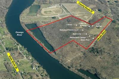

This Property Is For Sale
NEARBY LISTINGS FOR SALE OR LEASE
-
-
View all Fulton listings for sale on LoopNet.com
Property Detail
52 Nestle Ave
Syracuse, NY
Scribas Patent
355800-271-003-0002-009-000-0000
Oswego
Parkplaygroundpicnicarea
New York
AE
68.73 AC
36075C0469G
Oswego County
6,000 SF
Syracuse
DEMOGRAPHICS near 52 Nestle Ave
1 Mile
3 Mile
5 Mile
2024 Total Population
551
5,948
19,725
2029 Population
544
5,922
19,599
Pop Growth 2024-2029
(1.27%)
(0.44%)
(0.64%)
Average Age
45
42
41
2024 Total Households
227
2,419
8,072
HH Growth 2024-2029
(1.32%)
(0.45%)
(0.63%)
Median Household Inc
$71,099
$59,848
$55,006
Avg Household Size
2.40
2.40
2.40
2024 Avg HH Vehicles
2.00
2.00
2.00
Median Home Value
$162,195
$135,742
$107,284
Median Year Built
1975
1970
1961
Nearby Places
- Restaurants
- Banks
- Shops
- Fitness
- Groceries
PUBLIC TRANSPORTATION
AIRPORT
Syracuse Hancock International
DRIVE
WALK
Distance
Syracuse Hancock International
32 min
22.0 mi
Freight Ports
Albany, NY Port
DRIVE
WALK
Distance
Albany, NY Port
196 min
162.1 mi
Nearby Properties
Address
Land Use
TOTAL SIZE
Lot Size
Zoning
Address
Land Use
TOTAL SIZE
Lot Size
Zoning
127,601 SF
22.08 AC
C2
Address
Land Use
TOTAL SIZE
Lot Size
Zoning
178,780 SF
42.86 AC
R1
Address
Land Use
TOTAL SIZE
Lot Size
Zoning
33,416 SF
2.21 AC
R2
Address
Land Use
TOTAL SIZE
Lot Size
Zoning
98,307 SF
26.58 AC
R1
Address
Land Use
TOTAL SIZE
Lot Size
Zoning
793,000 SF
66.99 AC
I-1
Address
Land Use
TOTAL SIZE
Lot Size
Zoning
51,658 SF
1.43 AC
C2
Address
Land Use
TOTAL SIZE
Lot Size
Zoning
67,509 SF
8.34 AC
R1
Address
Land Use
TOTAL SIZE
Lot Size
Zoning
7,840 SF
2.76 AC
I-1
Address
Land Use
TOTAL SIZE
Lot Size
Zoning
31,806 SF
1.17 AC
R2
Address
Land Use
TOTAL SIZE
Lot Size
Zoning
20,839 SF
1.44 AC
R2
Address
Land Use
TOTAL SIZE
Lot Size
Zoning
124.55 AC
Address
Land Use
TOTAL SIZE
Lot Size
Zoning
17,393 SF
2.17 AC
M1
Address
Land Use
TOTAL SIZE
Lot Size
Zoning
29,000 SF
11.46 AC
Address
Land Use
TOTAL SIZE
Lot Size
Zoning
7,284 SF
4.20 AC
C2
Address
Land Use
TOTAL SIZE
Lot Size
Zoning
142.74 AC
I-1
Address
Land Use
TOTAL SIZE
Lot Size
Zoning
1,170 SF
C2
Address
Land Use
TOTAL SIZE
Lot Size
Zoning
1,536 SF
12.50 AC
C2
Address
Land Use
TOTAL SIZE
Lot Size
Zoning
3,500 SF
0.56 AC
C2
Address
Land Use
TOTAL SIZE
Lot Size
Zoning
7,324 SF
2 AC
I-1
Address
Land Use
TOTAL SIZE
Lot Size
Zoning
3,802 SF
1.23 AC
C2
Address
Land Use
TOTAL SIZE
Lot Size
Zoning
92.69 AC
I-1
Address
Land Use
TOTAL SIZE
Lot Size
Zoning
17,784 SF
6.07 AC
Address
Land Use
TOTAL SIZE
Lot Size
Zoning
3,480 SF
1.05 AC
C2
Address
Land Use
TOTAL SIZE
Lot Size
Zoning
7,800 SF
2.21 AC
C2
Address
Land Use
TOTAL SIZE
Lot Size
Zoning
3,857 SF
2.33 AC
C2
Address
Land Use
TOTAL SIZE
Lot Size
Zoning
135,436 SF
50.21 AC
I-1
Address
Land Use
TOTAL SIZE
Lot Size
Zoning
10,000 SF
0.23 AC
R5B
Address
Land Use
TOTAL SIZE
Lot Size
Zoning
9,000 SF
2.61 AC
M1
Address
Land Use
TOTAL SIZE
Lot Size
Zoning
18,976 SF
1.29 AC
C2
Address
Land Use
TOTAL SIZE
Lot Size
Zoning
2,150 SF
1.32 AC
C2
The World's #1 Commercial Real Estate Marketplace
Connect with us
© 2025 CoStar Group
The information above has been obtained from sources believed reliable. While we do not doubt its accuracy we have not verified it and make no guarantee, warranty or representation about it. It is your responsibility to independently confirm its accuracy and completeness. Any projections, opinions, assumptions, or estimates used are for example only and do not represent the current or future performance of the property. The value of this transaction to you depends on tax and other factors which should be evaluated by your tax, financial, and legal advisors. You and your advisors should conduct a careful, independent investigation of the property to determine to your satisfaction the suitability of the property for your needs.