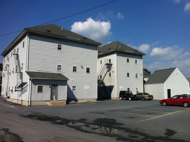
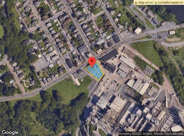
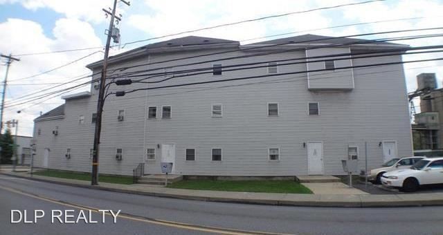
Property Record
5210 Main St, Whitehall, PA 18052
NEARBY LISTINGS FOR SALE OR LEASE
-
-
View all Whitehall listings for sale on LoopNet.com
Property Detail
5210 Main St
Allentown-Bethlehem-Easton, PA-NJ
Village Of Cementon
559001275075-1
LOTS: 001
Multifamilydwelling
Lehigh
X
Pennsylvania
42095C0209E
1
2024
0.53 AC
2024
Outer East Lehigh County
005601
Philadelphia
14,819 SF
DEMOGRAPHICS near 5210 Main St
1 Mile
3 Mile
5 Mile
2024 Total Population
8,674
38,277
79,571
2029 Population
8,754
38,467
80,133
Pop Growth 2024-2029
+ 0.92%
+ 0.50%
+ 0.71%
Average Age
41
42
42
2024 Total Households
3,597
15,492
31,710
HH Growth 2024-2029
+ 0.89%
+ 0.51%
+ 0.69%
Median Household Inc
$71,809
$75,195
$72,981
Avg Household Size
2.40
2.40
2.50
2024 Avg HH Vehicles
2.00
2.00
2.00
Median Home Value
$199,526
$231,247
$240,127
Median Year Built
1950
1965
1970
Nearby Places
- Restaurants
- Banks
- Shops
- Fitness
- Groceries
PUBLIC TRANSPORTATION
AIRPORT
Lehigh Valley International
DRIVE
WALK
Distance
Lehigh Valley International
11 min
6.0 mi
Freight Ports
Port of Philadelphia
DRIVE
WALK
Distance
Port of Philadelphia
90 min
68.0 mi
SALE & LEASE HISTORY
LISTING DATE
SALE/LEASE

Sep 27, 2017
For Sale
Sep 27, 2017
For Sale
Sep 27, 2017
For Sale
Nearby Properties
Address
Land Use
TOTAL SIZE
Lot Size
Zoning
Address
Land Use
TOTAL SIZE
Lot Size
Zoning
230,853 SF
96.66 AC
R-3
Address
Land Use
TOTAL SIZE
Lot Size
Zoning
175,714 SF
46.35 AC
R-3
Address
Land Use
TOTAL SIZE
Lot Size
Zoning
504,475 SF
39.36 AC
I
Address
Land Use
TOTAL SIZE
Lot Size
Zoning
956,444 SF
I
Address
Land Use
TOTAL SIZE
Lot Size
Zoning
85.20 AC
I2
Address
Land Use
TOTAL SIZE
Lot Size
Zoning
45,176 SF
11.04 AC
R-4
Address
Land Use
TOTAL SIZE
Lot Size
Zoning
105,219 SF
47.10 AC
RA
Address
Land Use
TOTAL SIZE
Lot Size
Zoning
605,893 SF
I
Address
Land Use
TOTAL SIZE
Lot Size
Zoning
164,816 SF
48.85 AC
R1
Address
Land Use
TOTAL SIZE
Lot Size
Zoning
24,878 SF
20.66 AC
AR
Address
Land Use
TOTAL SIZE
Lot Size
Zoning
65,524 SF
22.48 AC
I
Address
Land Use
TOTAL SIZE
Lot Size
Zoning
3,522 SF
20.74 AC
R3
Address
Land Use
TOTAL SIZE
Lot Size
Zoning
55,048 SF
12.47 AC
C-2A
Address
Land Use
TOTAL SIZE
Lot Size
Zoning
3,611 SF
108 AC
ME-I
Address
Land Use
TOTAL SIZE
Lot Size
Zoning
11,040 SF
4.18 AC
C-1
Address
Land Use
TOTAL SIZE
Lot Size
Zoning
29.22 AC
I2
Address
Land Use
TOTAL SIZE
Lot Size
Zoning
56,720 SF
4.17 AC
C-1
Address
Land Use
TOTAL SIZE
Lot Size
Zoning
8,280 SF
4.20 AC
R-5
Address
Land Use
TOTAL SIZE
Lot Size
Zoning
262,476 SF
30.77 AC
I2
Address
Land Use
TOTAL SIZE
Lot Size
Zoning
32,917 SF
6.04 AC
R-3A
Address
Land Use
TOTAL SIZE
Lot Size
Zoning
61,282 SF
0.96 AC
R3
Address
Land Use
TOTAL SIZE
Lot Size
Zoning
15,750 SF
5.10 AC
R-6
Address
Land Use
TOTAL SIZE
Lot Size
Zoning
3,600 SF
2.40 AC
C-2
Address
Land Use
TOTAL SIZE
Lot Size
Zoning
6,799 SF
2.82 AC
R-5
Address
Land Use
TOTAL SIZE
Lot Size
Zoning
9,068 SF
6.10 AC
R-4
Address
Land Use
TOTAL SIZE
Lot Size
Zoning
1,920 SF
26.19 AC
VR
Address
Land Use
TOTAL SIZE
Lot Size
Zoning
22,540 SF
1.59 AC
C-2
Address
Land Use
TOTAL SIZE
Lot Size
Zoning
15,789 SF
8.78 AC
R-4
Address
Land Use
TOTAL SIZE
Lot Size
Zoning
3,050 SF
3.91 AC
C-2
Address
Land Use
TOTAL SIZE
Lot Size
Zoning
1,815 SF
29.80 AC
R-6
The World's #1 Commercial Real Estate Marketplace
Connect with us
© 2025 CoStar Group
The information above has been obtained from sources believed reliable. While we do not doubt its accuracy we have not verified it and make no guarantee, warranty or representation about it. It is your responsibility to independently confirm its accuracy and completeness. Any projections, opinions, assumptions, or estimates used are for example only and do not represent the current or future performance of the property. The value of this transaction to you depends on tax and other factors which should be evaluated by your tax, financial, and legal advisors. You and your advisors should conduct a careful, independent investigation of the property to determine to your satisfaction the suitability of the property for your needs.