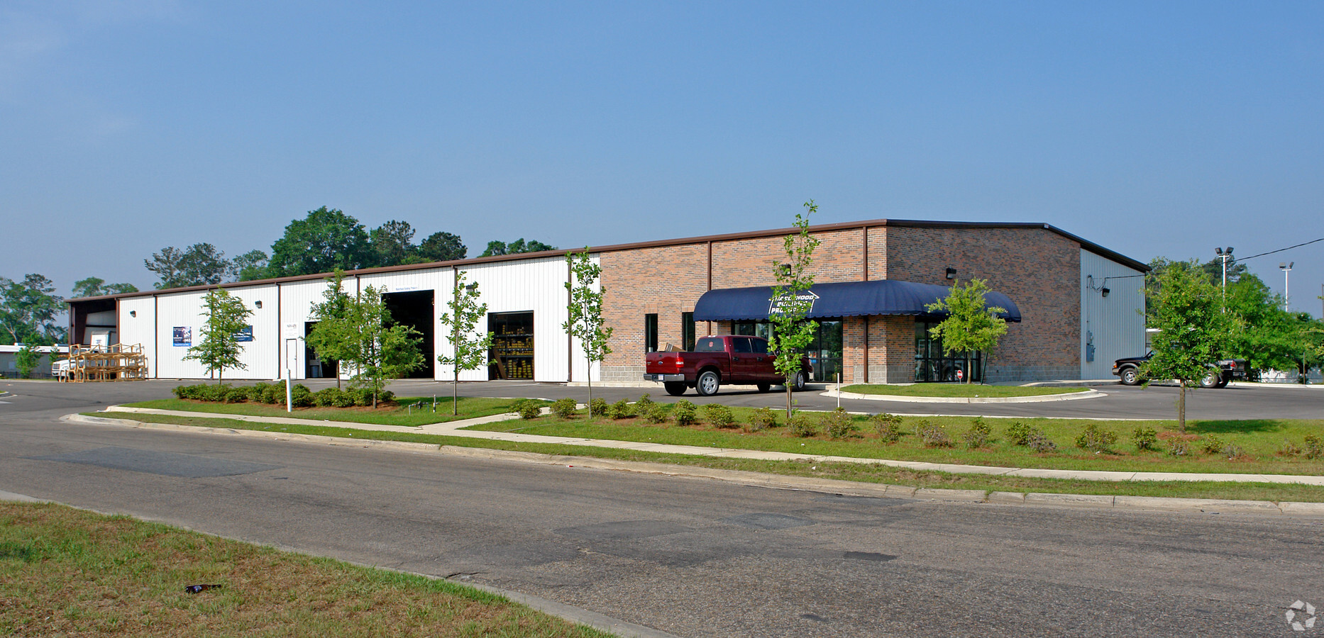
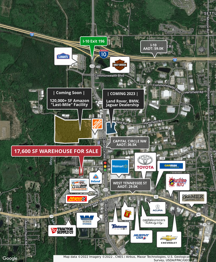
Property Record
5215 W Tharpe St, Tallahassee, FL 32303
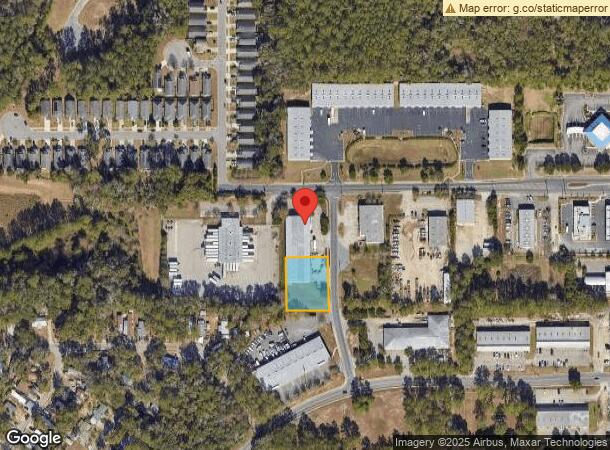
NEARBY LISTINGS FOR SALE OR LEASE
Property Detail
5215 W Tharpe St
Tallahassee, FL
Tharpe Street Commercial Park Unrecorded
21-30-62-00A-008.0
SECTION 30 T1N R1W THARPE ST COMMERCIAL PARK LOT 8 BLOCK A OR 5823/2334
Warehouse
Leon
X
Florida
12073C0278F
8
2024
1.27 AC
2024
Northwest Leon County
002304
Tallahassee
17,600 SF
DEMOGRAPHICS near 5215 W Tharpe St
1 Mile
3 Mile
5 Mile
2024 Total Population
3,867
41,826
104,940
2029 Population
4,160
43,966
109,714
Pop Growth 2024-2029
+ 7.58%
+ 5.12%
+ 4.55%
Average Age
32
32
32
2024 Total Households
1,505
17,245
43,750
HH Growth 2024-2029
+ 7.71%
+ 5.04%
+ 4.56%
Median Household Inc
$34,480
$39,414
$38,775
Avg Household Size
2.30
2.30
2.20
2024 Avg HH Vehicles
1.00
2.00
2.00
Median Home Value
$97,789
$150,415
$160,862
Median Year Built
1996
1989
1985
Nearby Places
- Restaurants
- Banks
- Shops
- Fitness
- Groceries
PUBLIC TRANSPORTATION
AIRPORT
Tallahassee International
DRIVE
WALK
Distance
Tallahassee International
10 min
5.1 mi
Freight Ports
Port of Panama City
DRIVE
WALK
Distance
Port of Panama City
136 min
100.8 mi
SALE & LEASE HISTORY
LISTING DATE
SALE/LEASE

Sep 06, 2022
For Sale
Nearby Properties
Address
Land Use
TOTAL SIZE
Lot Size
Zoning
Address
Land Use
TOTAL SIZE
Lot Size
Zoning
1,603,013 SF
175.71 AC
MR1
Address
Land Use
TOTAL SIZE
Lot Size
Zoning
959,505 SF
32.03 AC
M1
Address
Land Use
TOTAL SIZE
Lot Size
Zoning
758,762 SF
20.82 AC
UT
Address
Land Use
TOTAL SIZE
Lot Size
Zoning
719,149 SF
40.73 AC
MR1
Address
Land Use
TOTAL SIZE
Lot Size
Zoning
859,666 SF
20.17 AC
MR1
Address
Land Use
TOTAL SIZE
Lot Size
Zoning
556,751 SF
20.60 AC
CP
Address
Land Use
TOTAL SIZE
Lot Size
Zoning
738,711 SF
20.04 AC
MR1
Address
Land Use
TOTAL SIZE
Lot Size
Zoning
660,721 SF
30.95 AC
Address
Land Use
TOTAL SIZE
Lot Size
Zoning
358,501 SF
1.98 AC
UT
Address
Land Use
TOTAL SIZE
Lot Size
Zoning
123,904 SF
47.73 AC
I
Address
Land Use
TOTAL SIZE
Lot Size
Zoning
711,296 SF
17.86 AC
PUD
Address
Land Use
TOTAL SIZE
Lot Size
Zoning
127,486 SF
8.23 AC
M1
Address
Land Use
TOTAL SIZE
Lot Size
Zoning
597,764 SF
74.43 AC
M1
Address
Land Use
TOTAL SIZE
Lot Size
Zoning
588,955 SF
36.20 AC
R3
Address
Land Use
TOTAL SIZE
Lot Size
Zoning
236,679 SF
32.60 AC
MR1
Address
Land Use
TOTAL SIZE
Lot Size
Zoning
456,228 SF
27.14 AC
UT
Address
Land Use
TOTAL SIZE
Lot Size
Zoning
123,020 SF
9.45 AC
M1
Address
Land Use
TOTAL SIZE
Lot Size
Zoning
1,792 SF
231.63 AC
M1
Address
Land Use
TOTAL SIZE
Lot Size
Zoning
365,297 SF
9.50 AC
MR1
Address
Land Use
TOTAL SIZE
Lot Size
Zoning
570,525 SF
18.89 AC
MR1
Address
Land Use
TOTAL SIZE
Lot Size
Zoning
198,985 SF
22.18 AC
CP
Address
Land Use
TOTAL SIZE
Lot Size
Zoning
13.42 AC
UT
Address
Land Use
TOTAL SIZE
Lot Size
Zoning
680,597 SF
20.82 AC
UT
Address
Land Use
TOTAL SIZE
Lot Size
Zoning
162,726 SF
25.43 AC
CP
Address
Land Use
TOTAL SIZE
Lot Size
Zoning
343,694 SF
11.76 AC
MR1
Address
Land Use
TOTAL SIZE
Lot Size
Zoning
237,786 SF
10.55 AC
OR3
Address
Land Use
TOTAL SIZE
Lot Size
Zoning
146,297 SF
12.59 AC
MR1
Address
Land Use
TOTAL SIZE
Lot Size
Zoning
282,142 SF
9.33 AC
MR1
Address
Land Use
TOTAL SIZE
Lot Size
Zoning
287,352 SF
5.60 AC
MR1
Address
Land Use
TOTAL SIZE
Lot Size
Zoning
87,167 SF
20.36 AC
M1
The World's #1 Commercial Real Estate Marketplace
Connect with us
© 2025 CoStar Group
The information above has been obtained from sources believed reliable. While we do not doubt its accuracy we have not verified it and make no guarantee, warranty or representation about it. It is your responsibility to independently confirm its accuracy and completeness. Any projections, opinions, assumptions, or estimates used are for example only and do not represent the current or future performance of the property. The value of this transaction to you depends on tax and other factors which should be evaluated by your tax, financial, and legal advisors. You and your advisors should conduct a careful, independent investigation of the property to determine to your satisfaction the suitability of the property for your needs.