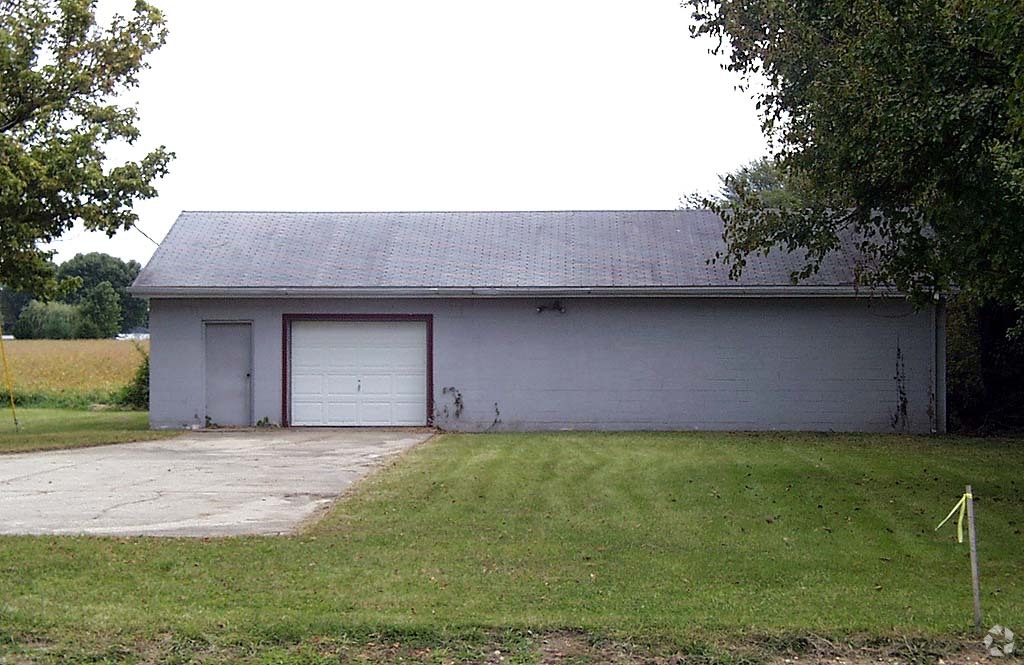
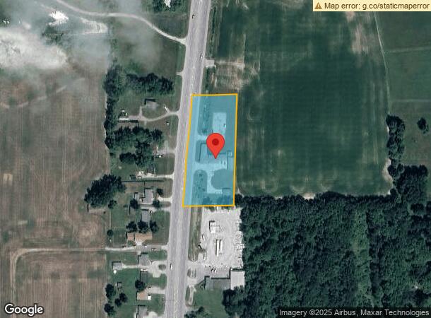
Property Record
5222 N State Road 9, Anderson, IN 46012
NEARBY LISTINGS FOR SALE OR LEASE
-
-
View all Anderson listings for sale on LoopNet.com
Property Detail
5222 N State Road 9
48-07-18-300-060.000-029
PT W2 SW 2.3000ACRES STR: 18208 SECTION: PLAT: 00 IN: OUT:
Commercialnec
Madison
X
Indiana
18095C0195D
2.30 AC
2023
Anderson/Madison Cnty
2024
Indianapolis
010700
Indianapolis-Carmel-Anderson, IN
6,733 SF
DEMOGRAPHICS near 5222 N State Road 9
1 Mile
3 Mile
5 Mile
2024 Total Population
1,167
5,939
24,666
2029 Population
1,184
6,075
25,196
Pop Growth 2024-2029
+ 1.46%
+ 2.29%
+ 2.15%
Average Age
45
44
43
2024 Total Households
478
2,468
9,969
HH Growth 2024-2029
+ 1.46%
+ 2.43%
+ 2.29%
Median Household Inc
$60,429
$55,000
$58,062
Avg Household Size
2.40
2.30
2.30
2024 Avg HH Vehicles
2.00
2.00
2.00
Median Home Value
$161,559
$139,640
$147,570
Median Year Built
1969
1965
1966
Nearby Places
- Restaurants
- Banks
- Shops
- Fitness
- Groceries
Nearby Properties
Address
Land Use
TOTAL SIZE
Lot Size
Zoning
Address
Land Use
TOTAL SIZE
Lot Size
Zoning
6,240 SF
7.60 AC
Address
Land Use
TOTAL SIZE
Lot Size
Zoning
72,218 SF
6.59 AC
Address
Land Use
TOTAL SIZE
Lot Size
Zoning
1.08 AC
Address
Land Use
TOTAL SIZE
Lot Size
Zoning
11,880 SF
8.50 AC
Address
Land Use
TOTAL SIZE
Lot Size
Zoning
20,541 SF
2.07 AC
Address
Land Use
TOTAL SIZE
Lot Size
Zoning
11,184 SF
2.90 AC
Address
Land Use
TOTAL SIZE
Lot Size
Zoning
8,880 SF
18.39 AC
Address
Land Use
TOTAL SIZE
Lot Size
Zoning
44,755 SF
2.21 AC
Address
Land Use
TOTAL SIZE
Lot Size
Zoning
8,832 SF
1.88 AC
Address
Land Use
TOTAL SIZE
Lot Size
Zoning
3,000 SF
3.28 AC
Address
Land Use
TOTAL SIZE
Lot Size
Zoning
88 SF
0.76 AC
Address
Land Use
TOTAL SIZE
Lot Size
Zoning
7,256 SF
5.86 AC
Address
Land Use
TOTAL SIZE
Lot Size
Zoning
60,348 SF
21.78 AC
Address
Land Use
TOTAL SIZE
Lot Size
Zoning
1.26 AC
Address
Land Use
TOTAL SIZE
Lot Size
Zoning
26,721 SF
5.38 AC
Address
Land Use
TOTAL SIZE
Lot Size
Zoning
0.87 AC
Address
Land Use
TOTAL SIZE
Lot Size
Zoning
31,992 SF
4.91 AC
Address
Land Use
TOTAL SIZE
Lot Size
Zoning
6,925 SF
1 AC
Address
Land Use
TOTAL SIZE
Lot Size
Zoning
15,364 SF
1 AC
Address
Land Use
TOTAL SIZE
Lot Size
Zoning
27,336 SF
2.59 AC
Address
Land Use
TOTAL SIZE
Lot Size
Zoning
45,682 SF
6.05 AC
Address
Land Use
TOTAL SIZE
Lot Size
Zoning
9,584 SF
9.40 AC
Address
Land Use
TOTAL SIZE
Lot Size
Zoning
5,016 SF
4.58 AC
Address
Land Use
TOTAL SIZE
Lot Size
Zoning
25,966 SF
4.89 AC
Address
Land Use
TOTAL SIZE
Lot Size
Zoning
40,472 SF
4.70 AC
Address
Land Use
TOTAL SIZE
Lot Size
Zoning
15,125 SF
13 AC
Address
Land Use
TOTAL SIZE
Lot Size
Zoning
22,529 SF
0.78 AC
Address
Land Use
TOTAL SIZE
Lot Size
Zoning
2,712 SF
345.78 AC
Address
Land Use
TOTAL SIZE
Lot Size
Zoning
16,940 SF
10.03 AC
Address
Land Use
TOTAL SIZE
Lot Size
Zoning
0.58 AC
The World's #1 Commercial Real Estate Marketplace
Connect with us
© 2025 CoStar Group
The information above has been obtained from sources believed reliable. While we do not doubt its accuracy we have not verified it and make no guarantee, warranty or representation about it. It is your responsibility to independently confirm its accuracy and completeness. Any projections, opinions, assumptions, or estimates used are for example only and do not represent the current or future performance of the property. The value of this transaction to you depends on tax and other factors which should be evaluated by your tax, financial, and legal advisors. You and your advisors should conduct a careful, independent investigation of the property to determine to your satisfaction the suitability of the property for your needs.