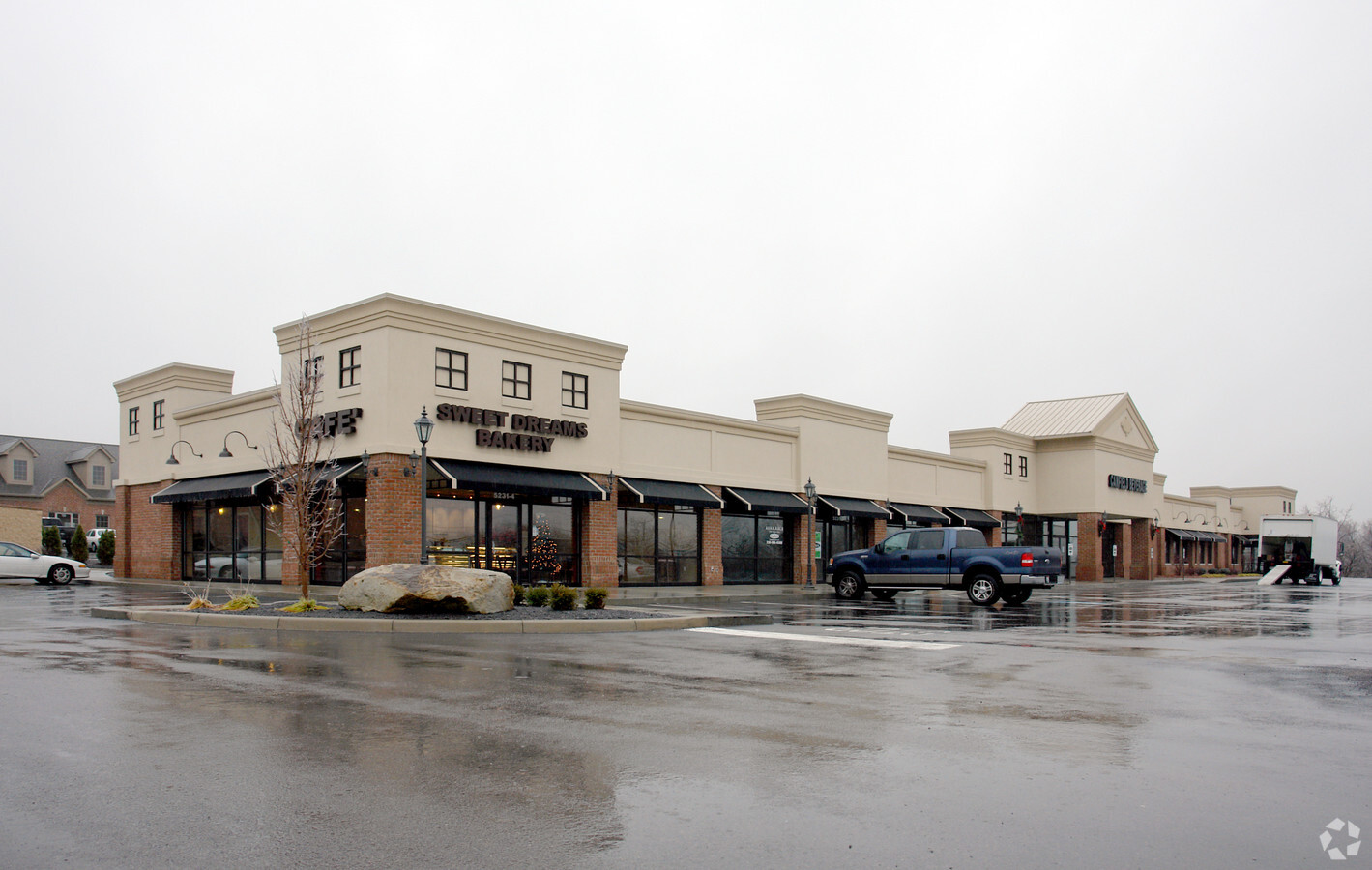
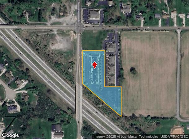
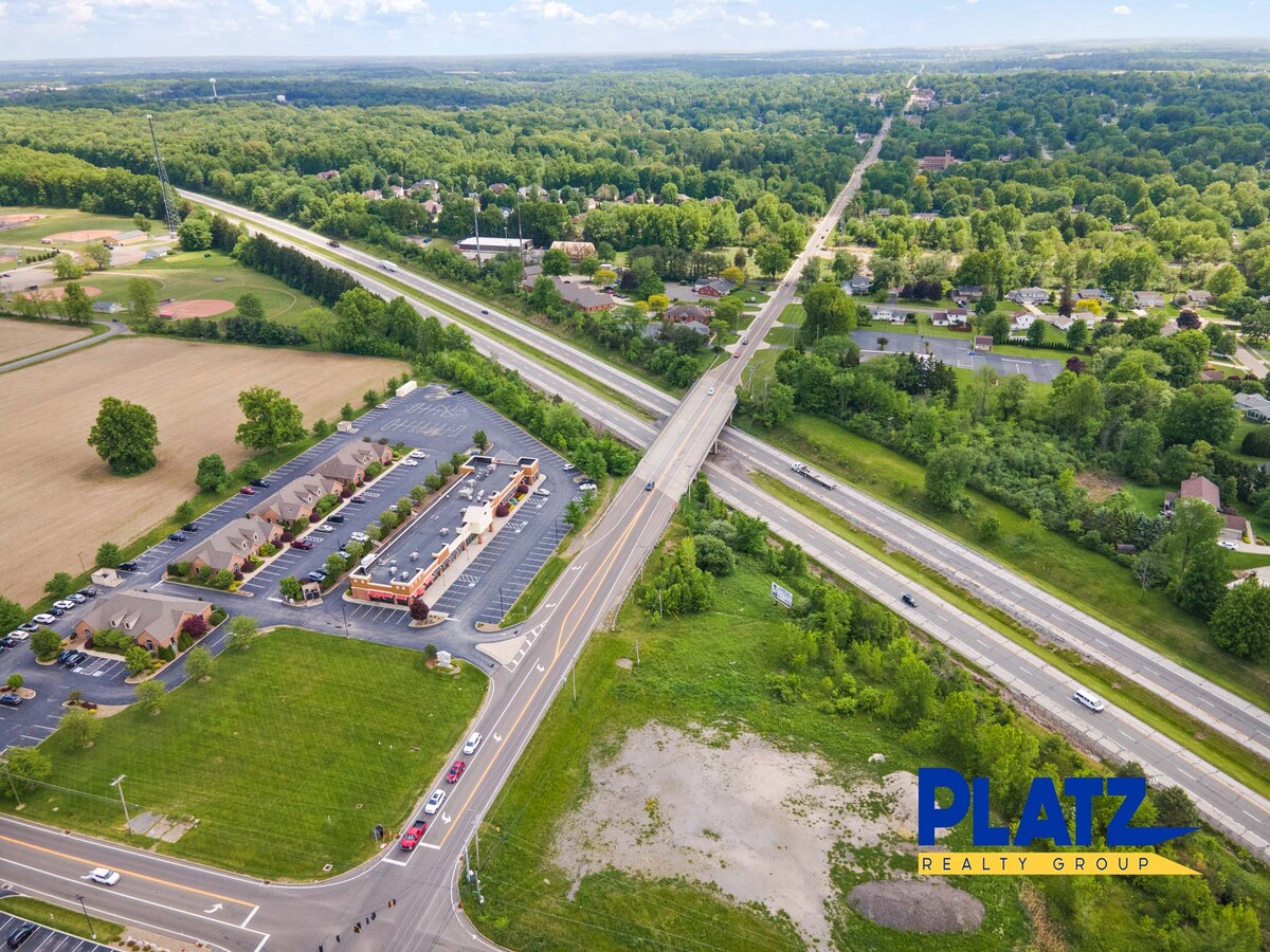
Property Record
5231 S Canfield Niles Rd, Canfield, OH 44406
NEARBY LISTINGS FOR SALE OR LEASE
Property Detail
5231 S Canfield Niles Rd
Youngstown/Warren/Boardman
Addison Reserve Plat No 1
Youngstown-Warren-Boardman, OH-PA
LOT 2 311.53 X 485.68 IRR REPLAT OF LOT NOS 2 & 3 ADDISON RESERVE PLAT NO 1
26-085-0-020.03-0
Mahoning
Regionalshoppingcenterormallwithanchorstore
Ohio
2023
2
2023
2.69 AC
812102
Mahoning County
12,524 SF
DEMOGRAPHICS near 5231 S Canfield Niles Rd
1 Mile
3 Mile
5 Mile
2024 Total Population
3,144
27,542
76,116
2029 Population
3,056
26,719
74,214
Pop Growth 2024-2029
(2.80%)
(2.99%)
(2.50%)
Average Age
43
45
44
2024 Total Households
1,181
11,666
34,059
HH Growth 2024-2029
(2.88%)
(3.03%)
(2.60%)
Median Household Inc
$107,932
$76,664
$58,904
Avg Household Size
2.70
2.30
2.20
2024 Avg HH Vehicles
2.00
2.00
2.00
Median Home Value
$242,093
$199,502
$156,700
Median Year Built
1977
1974
1966
Nearby Places
- Restaurants
- Banks
- Shops
- Fitness
- Groceries
SALE & LEASE HISTORY
LISTING DATE
SALE/LEASE

Sep 25, 2016
For Lease
Sep 12, 2017
For Lease
May 24, 2022
For Lease
Jan 22, 2024
For Lease
Nearby Properties
Address
Land Use
TOTAL SIZE
Lot Size
Zoning
Address
Land Use
TOTAL SIZE
Lot Size
Zoning
326,658 SF
78.41 AC
S
Address
Land Use
TOTAL SIZE
Lot Size
Zoning
Address
Land Use
TOTAL SIZE
Lot Size
Zoning
161,184 SF
29.51 AC
S
Address
Land Use
TOTAL SIZE
Lot Size
Zoning
47,538 SF
16.14 AC
C
Address
Land Use
TOTAL SIZE
Lot Size
Zoning
110,472 SF
18.39 AC
M1
Address
Land Use
TOTAL SIZE
Lot Size
Zoning
78,660 SF
22.36 AC
R3
Address
Land Use
TOTAL SIZE
Lot Size
Zoning
103,976 SF
16.14 AC
PUD
Address
Land Use
TOTAL SIZE
Lot Size
Zoning
33,854 SF
3.36 AC
R1
Address
Land Use
TOTAL SIZE
Lot Size
Zoning
89,623 SF
20.45 AC
ASER
Address
Land Use
TOTAL SIZE
Lot Size
Zoning
69,651 SF
2.43 AC
Address
Land Use
TOTAL SIZE
Lot Size
Zoning
46,813 SF
8.40 AC
Address
Land Use
TOTAL SIZE
Lot Size
Zoning
163,207 SF
9.19 AC
S
Address
Land Use
TOTAL SIZE
Lot Size
Zoning
332.96 AC
A
Address
Land Use
TOTAL SIZE
Lot Size
Zoning
59,999 SF
6.06 AC
B
Address
Land Use
TOTAL SIZE
Lot Size
Zoning
Address
Land Use
TOTAL SIZE
Lot Size
Zoning
56,432 SF
8.42 AC
B3
Address
Land Use
TOTAL SIZE
Lot Size
Zoning
58,972 SF
23.65 AC
S
Address
Land Use
TOTAL SIZE
Lot Size
Zoning
54,832 SF
2.01 AC
R2
Address
Land Use
TOTAL SIZE
Lot Size
Zoning
60,742 SF
10 AC
R1
Address
Land Use
TOTAL SIZE
Lot Size
Zoning
120.10 AC
Address
Land Use
TOTAL SIZE
Lot Size
Zoning
133,763 SF
39.18 AC
R1
Address
Land Use
TOTAL SIZE
Lot Size
Zoning
43,236 SF
13.30 AC
S
Address
Land Use
TOTAL SIZE
Lot Size
Zoning
48,546 SF
1.74 AC
B
Address
Land Use
TOTAL SIZE
Lot Size
Zoning
26,649 SF
23.60 AC
A
Address
Land Use
TOTAL SIZE
Lot Size
Zoning
19,348 SF
3.40 AC
B
Address
Land Use
TOTAL SIZE
Lot Size
Zoning
36,619 SF
76.78 AC
A
Address
Land Use
TOTAL SIZE
Lot Size
Zoning
39,684 SF
4.48 AC
B3
Address
Land Use
TOTAL SIZE
Lot Size
Zoning
33,912 SF
1.44 AC
Address
Land Use
TOTAL SIZE
Lot Size
Zoning
60,490 SF
15.08 AC
B2
Address
Land Use
TOTAL SIZE
Lot Size
Zoning
31,542 SF
7.83 AC
B2
The World's #1 Commercial Real Estate Marketplace
Connect with us
© 2025 CoStar Group
The information above has been obtained from sources believed reliable. While we do not doubt its accuracy we have not verified it and make no guarantee, warranty or representation about it. It is your responsibility to independently confirm its accuracy and completeness. Any projections, opinions, assumptions, or estimates used are for example only and do not represent the current or future performance of the property. The value of this transaction to you depends on tax and other factors which should be evaluated by your tax, financial, and legal advisors. You and your advisors should conduct a careful, independent investigation of the property to determine to your satisfaction the suitability of the property for your needs.