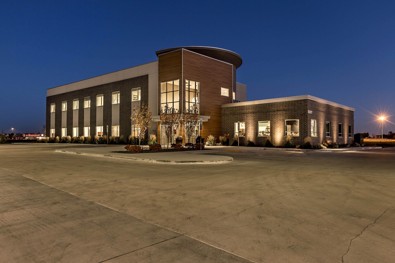
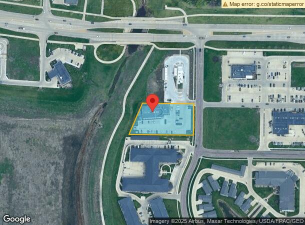
Property Record
5257 27Th St S, Fargo, ND 58104
NEARBY LISTINGS FOR SALE OR LEASE
Property Detail
5257 27Th St S
Fargo, ND-MN
Prairie Grove 4Th
01-8593-00200-000
LOT: 2 BLOCK: 1 ADDITION: ADDITIONAL: PRAIRIE GROVE 4TH ADDN LT 2 BLK 1 **1-22-16 REPLAT FRM 01-8386-00020-000 PER PLAT
Realpropertynec
Cass
AE
North Dakota
38017C0787G
2
2024
1.20 AC
2024
South Fargo
040505
Other Market Areas
15,618 SF
DEMOGRAPHICS near 5257 27Th St S
1 Mile
3 Mile
5 Mile
2024 Total Population
7,891
55,910
142,788
2029 Population
8,515
60,126
152,496
Pop Growth 2024-2029
+ 7.91%
+ 7.54%
+ 6.80%
Average Age
37
36
36
2024 Total Households
3,086
23,552
60,581
HH Growth 2024-2029
+ 8.39%
+ 7.94%
+ 7.20%
Median Household Inc
$116,773
$73,408
$69,429
Avg Household Size
2.50
2.30
2.30
2024 Avg HH Vehicles
2.00
2.00
2.00
Median Home Value
$320,656
$289,316
$274,177
Median Year Built
2010
2002
1999
Nearby Places
- Restaurants
- Banks
- Shops
- Fitness
- Groceries
PUBLIC TRANSPORTATION
COMMUTER RAIL
Fargo Amtrak Station (Empire Builder - Amtrak)
DRIVE
WALK
Distance
Fargo Amtrak Station (Empire Builder - Amtrak)
14 min
7.0 mi
AIRPORT
Hector International
DRIVE
WALK
Distance
Hector International
19 min
11.3 mi
Freight Ports
Port Milwaukee
DRIVE
WALK
Distance
Port Milwaukee
632 min
575.2 mi
SALE & LEASE HISTORY
LISTING DATE
SALE/LEASE

Mar 10, 2023
For Lease
Nearby Properties
Address
Land Use
TOTAL SIZE
Lot Size
Zoning
Address
Land Use
TOTAL SIZE
Lot Size
Zoning
161,184 SF
10.51 AC
GC
Address
Land Use
TOTAL SIZE
Lot Size
Zoning
55.68 AC
Address
Land Use
TOTAL SIZE
Lot Size
Zoning
Address
Land Use
TOTAL SIZE
Lot Size
Zoning
7.66 AC
Address
Land Use
TOTAL SIZE
Lot Size
Zoning
Address
Land Use
TOTAL SIZE
Lot Size
Zoning
64,653 SF
2.20 AC
MR3
Address
Land Use
TOTAL SIZE
Lot Size
Zoning
30,240 SF
1.54 AC
MR2
Address
Land Use
TOTAL SIZE
Lot Size
Zoning
Address
Land Use
TOTAL SIZE
Lot Size
Zoning
217,776 SF
31.82 AC
GC
Address
Land Use
TOTAL SIZE
Lot Size
Zoning
Address
Land Use
TOTAL SIZE
Lot Size
Zoning
122,201 SF
8.92 AC
GO
Address
Land Use
TOTAL SIZE
Lot Size
Zoning
191,151 SF
22.98 AC
LC
Address
Land Use
TOTAL SIZE
Lot Size
Zoning
123,777 SF
1.90 AC
Address
Land Use
TOTAL SIZE
Lot Size
Zoning
387,326 SF
16.51 AC
GC
Address
Land Use
TOTAL SIZE
Lot Size
Zoning
Address
Land Use
TOTAL SIZE
Lot Size
Zoning
88,956 SF
10.56 AC
GO
Address
Land Use
TOTAL SIZE
Lot Size
Zoning
160,913 SF
11.46 AC
GC
Address
Land Use
TOTAL SIZE
Lot Size
Zoning
Address
Land Use
TOTAL SIZE
Lot Size
Zoning
42,476 SF
2.07 AC
MR1
Address
Land Use
TOTAL SIZE
Lot Size
Zoning
3.72 AC
Address
Land Use
TOTAL SIZE
Lot Size
Zoning
44,851 SF
19 AC
LI
Address
Land Use
TOTAL SIZE
Lot Size
Zoning
Address
Land Use
TOTAL SIZE
Lot Size
Zoning
38,325 SF
465,408 AC
MR3
Address
Land Use
TOTAL SIZE
Lot Size
Zoning
51,509 SF
4.35 AC
GC
Address
Land Use
TOTAL SIZE
Lot Size
Zoning
54,870 SF
5.43 AC
MR3
Address
Land Use
TOTAL SIZE
Lot Size
Zoning
165,824 SF
5.38 AC
MR1
Address
Land Use
TOTAL SIZE
Lot Size
Zoning
Address
Land Use
TOTAL SIZE
Lot Size
Zoning
75,600 SF
3.82 AC
LC
Address
Land Use
TOTAL SIZE
Lot Size
Zoning
Address
Land Use
TOTAL SIZE
Lot Size
Zoning
5.92 AC
The World's #1 Commercial Real Estate Marketplace
Connect with us
© 2025 CoStar Group
The information above has been obtained from sources believed reliable. While we do not doubt its accuracy we have not verified it and make no guarantee, warranty or representation about it. It is your responsibility to independently confirm its accuracy and completeness. Any projections, opinions, assumptions, or estimates used are for example only and do not represent the current or future performance of the property. The value of this transaction to you depends on tax and other factors which should be evaluated by your tax, financial, and legal advisors. You and your advisors should conduct a careful, independent investigation of the property to determine to your satisfaction the suitability of the property for your needs.