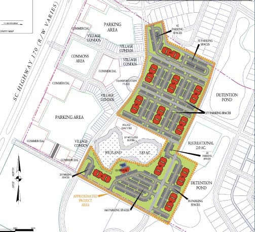
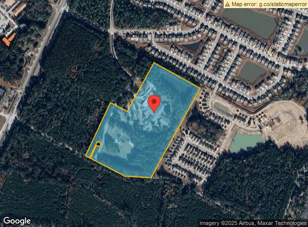
Property Record
53 Cherry Point Rd, Okatie, SC 29909
NEARBY LISTINGS FOR SALE OR LEASE
Property Detail
53 Cherry Point Rd
Hilton Head Island-Bluffton-Beaufort, SC
Okatie Road Commercial
R600-013-000-0104-0000
OKATIE ELEMENTARY SCHOOL PARCEL B PB68 P10SPLIT 10/03 0.11 AC 13/241PB118 P5
Privateschool
Beaufort
2024
South Carolina
2024
27.89 AC
002202
Hilton Head/Beaufort
76,410 SF
Other Market Areas
DEMOGRAPHICS near 53 Cherry Point Rd
1 Mile
3 Mile
5 Mile
2024 Total Population
1,192
13,258
40,461
2029 Population
1,434
15,916
46,157
Pop Growth 2024-2029
+ 20.30%
+ 20.05%
+ 14.08%
Average Age
51
52
51
2024 Total Households
541
6,110
17,783
HH Growth 2024-2029
+ 20.70%
+ 20.33%
+ 14.00%
Median Household Inc
$89,499
$79,513
$78,626
Avg Household Size
2.20
2.10
2.20
2024 Avg HH Vehicles
2.00
2.00
2.00
Median Home Value
$492,441
$424,297
$367,517
Median Year Built
2007
2007
2005
Nearby Places
- Restaurants
- Banks
- Shops
- Fitness
- Groceries
PUBLIC TRANSPORTATION
AIRPORT
Hilton Head
DRIVE
WALK
Distance
Hilton Head
30 min
19.7 mi
Savannah/Hilton Head International
DRIVE
WALK
Distance
Savannah/Hilton Head International
44 min
30.7 mi
Freight Ports
Georgia Ports - Savannah
DRIVE
WALK
Distance
Georgia Ports - Savannah
40 min
29.1 mi
Nearby Properties
Address
Land Use
TOTAL SIZE
Lot Size
Zoning
Address
Land Use
TOTAL SIZE
Lot Size
Zoning
896 SF
70.66 AC
Address
Land Use
TOTAL SIZE
Lot Size
Zoning
1,120 SF
5 AC
RC
Address
Land Use
TOTAL SIZE
Lot Size
Zoning
2.61 AC
RC
Address
Land Use
TOTAL SIZE
Lot Size
Zoning
1,248 SF
39.20 AC
PDD
Address
Land Use
TOTAL SIZE
Lot Size
Zoning
1,632 SF
18.20 AC
PDD
Address
Land Use
TOTAL SIZE
Lot Size
Zoning
1,632 SF
2.85 AC
PDD
Address
Land Use
TOTAL SIZE
Lot Size
Zoning
1,632 SF
5.42 AC
RA
Address
Land Use
TOTAL SIZE
Lot Size
Zoning
77,813 SF
22.12 AC
Address
Land Use
TOTAL SIZE
Lot Size
Zoning
188,132 SF
10.59 AC
Address
Land Use
TOTAL SIZE
Lot Size
Zoning
1,064 SF
29.45 AC
PDD
Address
Land Use
TOTAL SIZE
Lot Size
Zoning
90,696 SF
62.80 AC
Address
Land Use
TOTAL SIZE
Lot Size
Zoning
980 SF
0.59 AC
RC
Address
Land Use
TOTAL SIZE
Lot Size
Zoning
67,941 SF
15.45 AC
Address
Land Use
TOTAL SIZE
Lot Size
Zoning
9,654 SF
23.27 AC
6106
Address
Land Use
TOTAL SIZE
Lot Size
Zoning
7.22 AC
Address
Land Use
TOTAL SIZE
Lot Size
Zoning
0.18 AC
Address
Land Use
TOTAL SIZE
Lot Size
Zoning
81,625 SF
5.43 AC
Address
Land Use
TOTAL SIZE
Lot Size
Zoning
0.19 AC
Address
Land Use
TOTAL SIZE
Lot Size
Zoning
1,632 SF
172.10 AC
RA
Address
Land Use
TOTAL SIZE
Lot Size
Zoning
29,549 SF
17.88 AC
6106
Address
Land Use
TOTAL SIZE
Lot Size
Zoning
0.19 AC
Address
Land Use
TOTAL SIZE
Lot Size
Zoning
65,592 SF
3.33 AC
6606
Address
Land Use
TOTAL SIZE
Lot Size
Zoning
3,604 SF
5.10 AC
R1
Address
Land Use
TOTAL SIZE
Lot Size
Zoning
3,296 SF
4.56 AC
PDD
Address
Land Use
TOTAL SIZE
Lot Size
Zoning
43,031 SF
5.92 AC
6606
Address
Land Use
TOTAL SIZE
Lot Size
Zoning
53,860 SF
3.49 AC
Address
Land Use
TOTAL SIZE
Lot Size
Zoning
1,680 SF
6.68 AC
PDD
The World's #1 Commercial Real Estate Marketplace
Connect with us
© 2025 CoStar Group
The information above has been obtained from sources believed reliable. While we do not doubt its accuracy we have not verified it and make no guarantee, warranty or representation about it. It is your responsibility to independently confirm its accuracy and completeness. Any projections, opinions, assumptions, or estimates used are for example only and do not represent the current or future performance of the property. The value of this transaction to you depends on tax and other factors which should be evaluated by your tax, financial, and legal advisors. You and your advisors should conduct a careful, independent investigation of the property to determine to your satisfaction the suitability of the property for your needs.