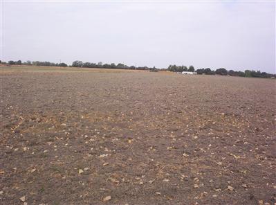
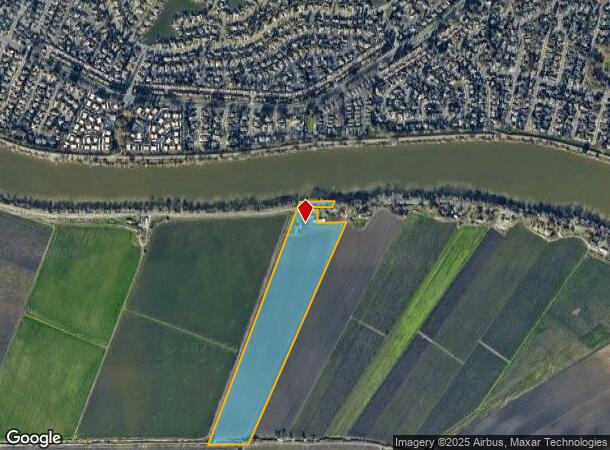
Property Record
53151 S River Rd, Clarksburg, CA 95612
NEARBY LISTINGS FOR SALE OR LEASE
-
-
View all Clarksburg listings for sale on LoopNet.com
Property Detail
53151 S River Rd
Farms
Yolo
AE
California
06067C0285H
38.23 AC
2023
Davis/Woodland
2023
Sacramento
010401
Sacramento--Roseville--Arden-Arcade, CA
1,788 SF
044-060-024-000
DEMOGRAPHICS near 53151 S River Rd
1 Mile
3 Mile
5 Mile
2024 Total Population
77
10,192
131,447
2029 Population
72
10,181
131,938
Pop Growth 2024-2029
(6.49%)
(0.11%)
+ 0.37%
Average Age
43
40
39
2024 Total Households
28
3,702
43,871
HH Growth 2024-2029
(3.57%)
(0.05%)
+ 0.34%
Median Household Inc
$74,999
$117,757
$93,063
Avg Household Size
2.50
2.70
2.90
2024 Avg HH Vehicles
2.00
2.00
2.00
Median Home Value
$799,999
$697,910
$478,367
Median Year Built
1948
1994
1986
Nearby Places
- Restaurants
- Banks
- Shops
- Fitness
- Groceries
PUBLIC TRANSPORTATION
AIRPORT
Sacramento International
DRIVE
WALK
Distance
Sacramento International
31 min
22.9 mi
Freight Ports
Port of Stockton
DRIVE
WALK
Distance
Port of Stockton
48 min
40.6 mi
Nearby Properties
Address
Land Use
TOTAL SIZE
Lot Size
Zoning
Address
Land Use
TOTAL SIZE
Lot Size
Zoning
253,984 SF
11.58 AC
R-2B-PUD
Address
Land Use
TOTAL SIZE
Lot Size
Zoning
12.70 AC
SC-PUD
Address
Land Use
TOTAL SIZE
Lot Size
Zoning
180,344 SF
11.86 AC
R-2A
Address
Land Use
TOTAL SIZE
Lot Size
Zoning
165,704 SF
9.57 AC
R-2B-R
Address
Land Use
TOTAL SIZE
Lot Size
Zoning
175,855 SF
8.90 AC
R-2B-R-PUD
Address
Land Use
TOTAL SIZE
Lot Size
Zoning
170,514 SF
9 AC
R-2B-R-PUD
Address
Land Use
TOTAL SIZE
Lot Size
Zoning
213,260 SF
14.35 AC
R-3-R
Address
Land Use
TOTAL SIZE
Lot Size
Zoning
173,323 SF
10.39 AC
C-2-PUD
Address
Land Use
TOTAL SIZE
Lot Size
Zoning
13.87 AC
C-2-PUD
Address
Land Use
TOTAL SIZE
Lot Size
Zoning
140,408 SF
5.90 AC
R-3
Address
Land Use
TOTAL SIZE
Lot Size
Zoning
166,941 SF
7.46 AC
R-2B-PUD
Address
Land Use
TOTAL SIZE
Lot Size
Zoning
64,082 SF
2.38 AC
R-1
Address
Land Use
TOTAL SIZE
Lot Size
Zoning
187,708 SF
13.50 AC
C-2-PUD
Address
Land Use
TOTAL SIZE
Lot Size
Zoning
Address
Land Use
TOTAL SIZE
Lot Size
Zoning
156,873 SF
14.98 AC
C-2-PUD
Address
Land Use
TOTAL SIZE
Lot Size
Zoning
267,580 SF
16.12 AC
R-1A
Address
Land Use
TOTAL SIZE
Lot Size
Zoning
181,766 SF
4.79 AC
R-4-PUD
Address
Land Use
TOTAL SIZE
Lot Size
Zoning
137,916 SF
11.62 AC
SC-R
Address
Land Use
TOTAL SIZE
Lot Size
Zoning
227,396 SF
15.76 AC
R-2A-R-EA-
Address
Land Use
TOTAL SIZE
Lot Size
Zoning
165,523 SF
15.76 AC
MRD-PUD OB
Address
Land Use
TOTAL SIZE
Lot Size
Zoning
85,131 SF
7.40 AC
C-2-PUD
Address
Land Use
TOTAL SIZE
Lot Size
Zoning
84,087 SF
4.11 AC
R-3-R
Address
Land Use
TOTAL SIZE
Lot Size
Zoning
162,259 SF
12.73 AC
R-3
Address
Land Use
TOTAL SIZE
Lot Size
Zoning
45,949 SF
4.24 AC
R-2A
Address
Land Use
TOTAL SIZE
Lot Size
Zoning
6.34 AC
C-2-PUD
Address
Land Use
TOTAL SIZE
Lot Size
Zoning
106,803 SF
7.18 AC
R-2A-R
Address
Land Use
TOTAL SIZE
Lot Size
Zoning
29.28 AC
C-2-PUD R-
Address
Land Use
TOTAL SIZE
Lot Size
Zoning
79,915 SF
3.70 AC
R-3
Address
Land Use
TOTAL SIZE
Lot Size
Zoning
105,700 SF
12.41 AC
C-2-R
Address
Land Use
TOTAL SIZE
Lot Size
Zoning
65,560 SF
4.08 AC
R-2B-R
The World's #1 Commercial Real Estate Marketplace
Connect with us
© 2025 CoStar Group
The information above has been obtained from sources believed reliable. While we do not doubt its accuracy we have not verified it and make no guarantee, warranty or representation about it. It is your responsibility to independently confirm its accuracy and completeness. Any projections, opinions, assumptions, or estimates used are for example only and do not represent the current or future performance of the property. The value of this transaction to you depends on tax and other factors which should be evaluated by your tax, financial, and legal advisors. You and your advisors should conduct a careful, independent investigation of the property to determine to your satisfaction the suitability of the property for your needs.