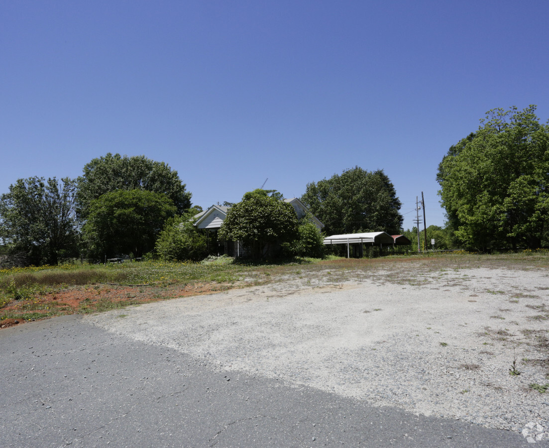
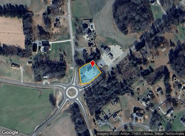
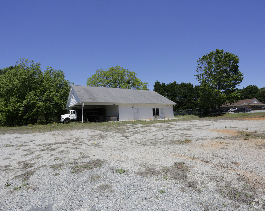
Property Record
5318 Lancaster Hwy, Monroe, NC 28112
NEARBY LISTINGS FOR SALE OR LEASE
-
-
View all Monroe listings for sale on LoopNet.com
Property Detail
5318 Lancaster Hwy
04-279-046-A
7888-292 LESS 8298-324
Commercialnec
Union
X
North Carolina
3710540200J
1.48 AC
2024
Union County
2024
Charlotte
021005
Charlotte-Concord-Gastonia, NC-SC
1,026 SF
DEMOGRAPHICS near 5318 Lancaster Hwy
1 Mile
3 Mile
5 Mile
2024 Total Population
957
4,821
14,606
2029 Population
1,073
5,445
16,508
Pop Growth 2024-2029
+ 12.12%
+ 12.94%
+ 13.02%
Average Age
43
42
42
2024 Total Households
366
1,799
5,420
HH Growth 2024-2029
+ 12.30%
+ 13.06%
+ 13.17%
Median Household Inc
$72,058
$80,950
$81,336
Avg Household Size
2.60
2.60
2.60
2024 Avg HH Vehicles
3.00
3.00
2.00
Median Home Value
$278,787
$279,116
$276,338
Median Year Built
1990
1991
1993
Nearby Places
- Restaurants
- Banks
- Shops
- Fitness
- Groceries
PUBLIC TRANSPORTATION
AIRPORT
Charlotte/Douglas International
DRIVE
WALK
Distance
Charlotte/Douglas International
57 min
36.9 mi
Freight Ports
North Charleston Terminal
DRIVE
WALK
Distance
North Charleston Terminal
215 min
181.0 mi
SALE & LEASE HISTORY
LISTING DATE
SALE/LEASE

May 11, 2017
For Sale
Nearby Properties
Address
Land Use
TOTAL SIZE
Lot Size
Zoning
Address
Land Use
TOTAL SIZE
Lot Size
Zoning
42,303 SF
36.65 AC
RA-40 UNIO
Address
Land Use
TOTAL SIZE
Lot Size
Zoning
61,902 SF
30.04 AC
RA-40 UNIO
Address
Land Use
TOTAL SIZE
Lot Size
Zoning
9,750 SF
197.04 AC
RA-40 UNIO
Address
Land Use
TOTAL SIZE
Lot Size
Zoning
49,276 SF
15.29 AC
RA-40 UNIO
Address
Land Use
TOTAL SIZE
Lot Size
Zoning
356.09 AC
RA-40 UNIO
Address
Land Use
TOTAL SIZE
Lot Size
Zoning
26,765 SF
53.48 AC
RA-40 UNIO
Address
Land Use
TOTAL SIZE
Lot Size
Zoning
7.50 AC
RA-40 UNIO
Address
Land Use
TOTAL SIZE
Lot Size
Zoning
6.60 AC
RA-40 UNIO
Address
Land Use
TOTAL SIZE
Lot Size
Zoning
4,000 SF
2.76 AC
B-4 UNION
Address
Land Use
TOTAL SIZE
Lot Size
Zoning
6.23 AC
RA-40 UNIO
Address
Land Use
TOTAL SIZE
Lot Size
Zoning
3.53 AC
RA-40 UNIO
Address
Land Use
TOTAL SIZE
Lot Size
Zoning
3.27 AC
RA-40 UNIO
Address
Land Use
TOTAL SIZE
Lot Size
Zoning
6.53 AC
RA-40 UNIO
Address
Land Use
TOTAL SIZE
Lot Size
Zoning
6.60 AC
RA-40 UNIO
Address
Land Use
TOTAL SIZE
Lot Size
Zoning
95.65 AC
RA-40 UNIO
Address
Land Use
TOTAL SIZE
Lot Size
Zoning
94.85 AC
RA-40 UNIO
Address
Land Use
TOTAL SIZE
Lot Size
Zoning
6,240 SF
7.57 AC
RA-40 UNIO
Address
Land Use
TOTAL SIZE
Lot Size
Zoning
22.40 AC
RA-40 UNIO
Address
Land Use
TOTAL SIZE
Lot Size
Zoning
9,800 SF
6.35 AC
RA-40 UNIO
Address
Land Use
TOTAL SIZE
Lot Size
Zoning
1.72 AC
RA-40 UNIO
Address
Land Use
TOTAL SIZE
Lot Size
Zoning
10.47 AC
RA-40 UNIO
Address
Land Use
TOTAL SIZE
Lot Size
Zoning
90.65 AC
Address
Land Use
TOTAL SIZE
Lot Size
Zoning
77.74 AC
RA-40 UNIO
Address
Land Use
TOTAL SIZE
Lot Size
Zoning
0.61 AC
RA-40 UNIO
Address
Land Use
TOTAL SIZE
Lot Size
Zoning
1.27 AC
RA-40 UNIO
Address
Land Use
TOTAL SIZE
Lot Size
Zoning
6,936 SF
13.50 AC
RA-40 UNIO
Address
Land Use
TOTAL SIZE
Lot Size
Zoning
6.77 AC
RA-40 UNIO
Address
Land Use
TOTAL SIZE
Lot Size
Zoning
0.92 AC
RA-40 UNIO
Address
Land Use
TOTAL SIZE
Lot Size
Zoning
13.52 AC
AR MINERAL
Address
Land Use
TOTAL SIZE
Lot Size
Zoning
0.92 AC
RA-40 UNIO
The World's #1 Commercial Real Estate Marketplace
Connect with us
© 2025 CoStar Group
The information above has been obtained from sources believed reliable. While we do not doubt its accuracy we have not verified it and make no guarantee, warranty or representation about it. It is your responsibility to independently confirm its accuracy and completeness. Any projections, opinions, assumptions, or estimates used are for example only and do not represent the current or future performance of the property. The value of this transaction to you depends on tax and other factors which should be evaluated by your tax, financial, and legal advisors. You and your advisors should conduct a careful, independent investigation of the property to determine to your satisfaction the suitability of the property for your needs.