Property Record
5362 Sparks Blvd, Sparks, NV 89436
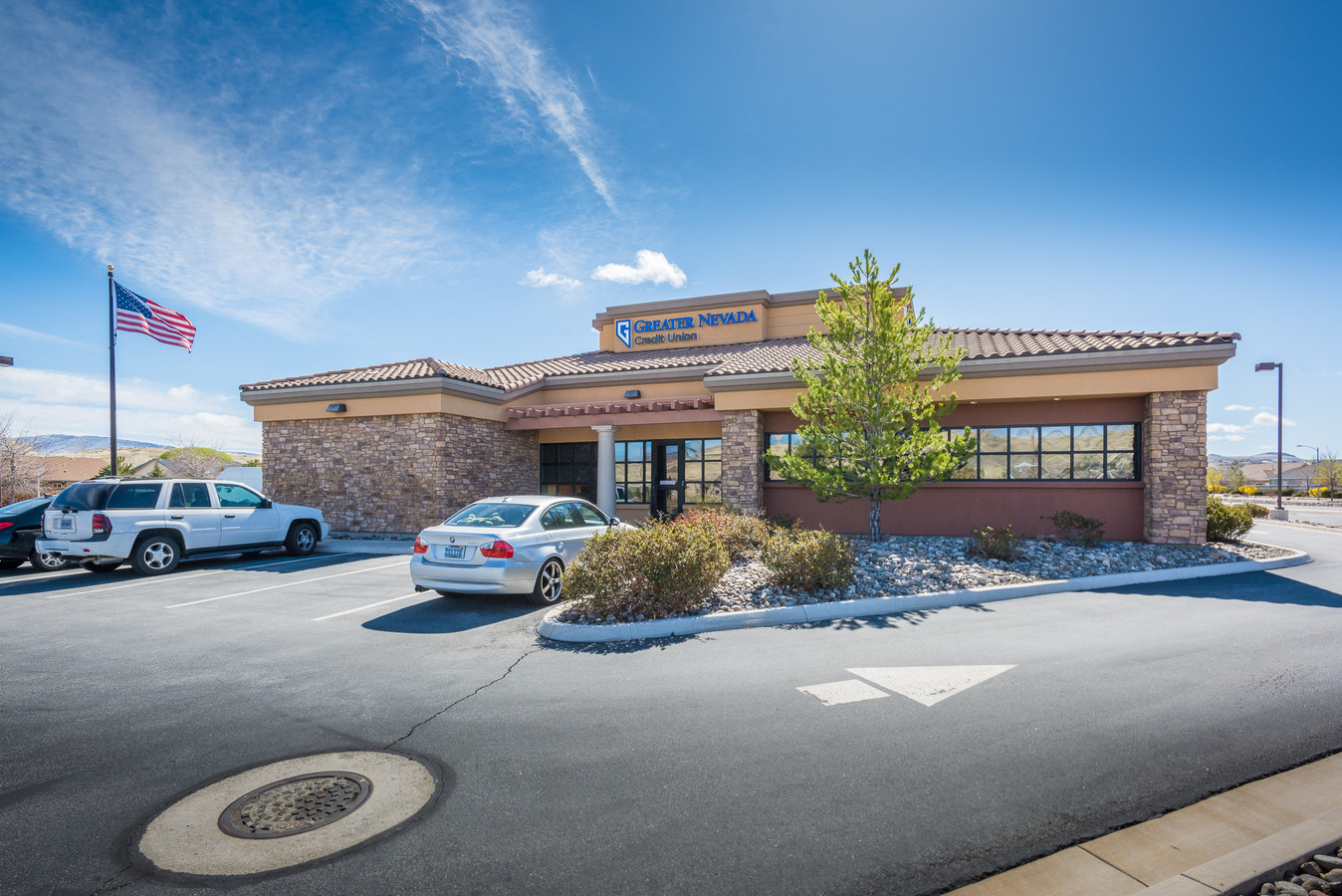

This Property Is For Sale
NEARBY LISTINGS FOR SALE OR LEASE
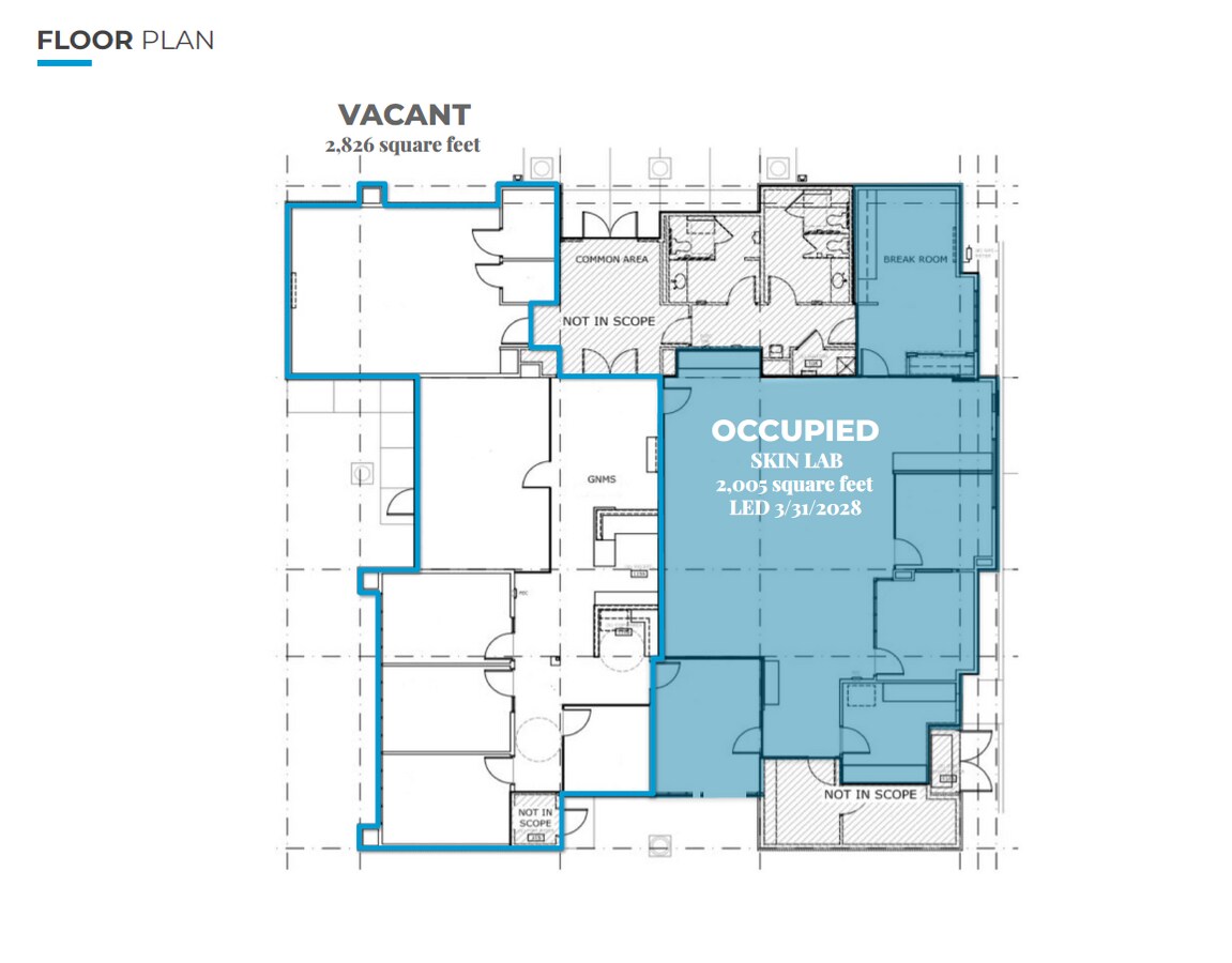
Property Detail
5362 Sparks Blvd
Reno, NV
_Unspecified
516-380-32
RS 4789 LT 2A
Commercialnec
Washoe
X
Nevada
32031C3053G
2a
2024
0.98 AC
2024
Sparks
003521
Reno/Sparks
4,831 SF
DEMOGRAPHICS near 5362 Sparks Blvd
1 Mile
3 Mile
5 Mile
2024 Total Population
11,444
72,540
169,554
2029 Population
11,973
76,219
178,779
Pop Growth 2024-2029
+ 4.62%
+ 5.07%
+ 5.44%
Average Age
40
39
39
2024 Total Households
4,277
25,677
63,002
HH Growth 2024-2029
+ 4.75%
+ 5.22%
+ 5.70%
Median Household Inc
$89,679
$87,592
$72,581
Avg Household Size
2.70
2.80
2.60
2024 Avg HH Vehicles
2.00
2.00
2.00
Median Home Value
$434,855
$405,904
$402,239
Median Year Built
2002
1994
1992
Nearby Places
- Restaurants
- Banks
- Shops
- Fitness
- Groceries
PUBLIC TRANSPORTATION
COMMUTER RAIL
Reno (California Zephyr - Amtrak)
DRIVE
WALK
Distance
Reno (California Zephyr - Amtrak)
16 min
8.5 mi
AIRPORT
Reno/Tahoe International
DRIVE
WALK
Distance
Reno/Tahoe International
34 min
12.3 mi
Freight Ports
Port of Stockton
DRIVE
WALK
Distance
Port of Stockton
219 min
186.6 mi
Nearby Properties
Address
Land Use
TOTAL SIZE
Lot Size
Zoning
Address
Land Use
TOTAL SIZE
Lot Size
Zoning
294,872 SF
69.02 AC
PF
Address
Land Use
TOTAL SIZE
Lot Size
Zoning
416,482 SF
21.84 AC
PD
Address
Land Use
TOTAL SIZE
Lot Size
Zoning
271,111 SF
31.84 AC
NUD
Address
Land Use
TOTAL SIZE
Lot Size
Zoning
406,338 SF
15.07 AC
NUD
Address
Land Use
TOTAL SIZE
Lot Size
Zoning
308,431 SF
20 AC
PD
Address
Land Use
TOTAL SIZE
Lot Size
Zoning
333,867 SF
14.71 AC
NUD
Address
Land Use
TOTAL SIZE
Lot Size
Zoning
236,695 SF
8.66 AC
PD
Address
Land Use
TOTAL SIZE
Lot Size
Zoning
279,596 SF
10.94 AC
NUD
Address
Land Use
TOTAL SIZE
Lot Size
Zoning
329,137 SF
36 AC
NUD
Address
Land Use
TOTAL SIZE
Lot Size
Zoning
246,076 SF
16.43 AC
PD
Address
Land Use
TOTAL SIZE
Lot Size
Zoning
248,124 SF
19.35 AC
PD
Address
Land Use
TOTAL SIZE
Lot Size
Zoning
273,101 SF
15.96 AC
MF-3/PUD
Address
Land Use
TOTAL SIZE
Lot Size
Zoning
237,680 SF
16.64 AC
PD
Address
Land Use
TOTAL SIZE
Lot Size
Zoning
203,303 SF
20.97 AC
C2
Address
Land Use
TOTAL SIZE
Lot Size
Zoning
230,897 SF
11.52 AC
NUD
Address
Land Use
TOTAL SIZE
Lot Size
Zoning
74,637 SF
6.04 AC
NUD
Address
Land Use
TOTAL SIZE
Lot Size
Zoning
13,874 SF
448.16 AC
PF
Address
Land Use
TOTAL SIZE
Lot Size
Zoning
269,970 SF
54.03 AC
PF
Address
Land Use
TOTAL SIZE
Lot Size
Zoning
70,030 SF
36.71 AC
PSP
Address
Land Use
TOTAL SIZE
Lot Size
Zoning
115,817 SF
11.27 AC
NUD
Address
Land Use
TOTAL SIZE
Lot Size
Zoning
38,107 SF
9.10 AC
PF
Address
Land Use
TOTAL SIZE
Lot Size
Zoning
119,709 SF
18.06 AC
PF
Address
Land Use
TOTAL SIZE
Lot Size
Zoning
57,702 SF
5.27 AC
PD
Address
Land Use
TOTAL SIZE
Lot Size
Zoning
89,264 SF
13.16 AC
C2
Address
Land Use
TOTAL SIZE
Lot Size
Zoning
102,489 SF
10.99 AC
NUD
Address
Land Use
TOTAL SIZE
Lot Size
Zoning
200,996 SF
14.77 AC
PD
Address
Land Use
TOTAL SIZE
Lot Size
Zoning
87,888 SF
9.58 AC
C2
Address
Land Use
TOTAL SIZE
Lot Size
Zoning
58,299 SF
6.75 AC
PD
Address
Land Use
TOTAL SIZE
Lot Size
Zoning
101,002 SF
4.42 AC
TC
Address
Land Use
TOTAL SIZE
Lot Size
Zoning
44,138 SF
4.09 AC
C2
The World's #1 Commercial Real Estate Marketplace
Connect with us
© 2025 CoStar Group
The information above has been obtained from sources believed reliable. While we do not doubt its accuracy we have not verified it and make no guarantee, warranty or representation about it. It is your responsibility to independently confirm its accuracy and completeness. Any projections, opinions, assumptions, or estimates used are for example only and do not represent the current or future performance of the property. The value of this transaction to you depends on tax and other factors which should be evaluated by your tax, financial, and legal advisors. You and your advisors should conduct a careful, independent investigation of the property to determine to your satisfaction the suitability of the property for your needs.