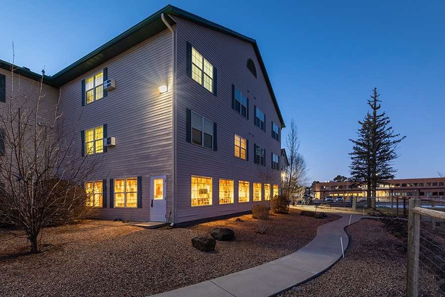
Property Record
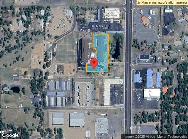
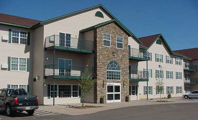
5408 Highway 260, Lakeside, AZ 85929
This Property Is For Sale
NEARBY LISTINGS FOR SALE OR LEASE
-
-
View all Lakeside listings for sale on LoopNet.com
Property Detail
5408 Highway 260
212-07-025P
SECTION 9,T9N,R22E:COM C 1/4 SEC 9; TH S00*1855 E 286.67; TH N8 9*1058 W 25.99; TH N89*1058 W 160 TPOB; TH S00*4902 W 400; TH N89*1058 W 325; TH N00*4902 E 400; TH S89*1058 E 325 TPO B. OUT OF 212-07-025C FOR2002ROLL LESS 0.002 AC TO 025L PER AC AD J
Hospitalprivate
Navajo
X
Arizona
04017C4709F
1.48 AC
2023
Arizona Northeast & Holbrook Area
2025
Other Market Areas
961702
Show Low, AZ
56,096 SF
DEMOGRAPHICS near 5408 Highway 260
1 Mile
3 Mile
5 Mile
2024 Total Population
2,761
8,871
21,029
2029 Population
3,050
9,645
22,735
Pop Growth 2024-2029
+ 10.47%
+ 8.73%
+ 8.11%
Average Age
45
45
43
2024 Total Households
1,101
3,526
8,550
HH Growth 2024-2029
+ 10.45%
+ 8.56%
+ 7.98%
Median Household Inc
$43,624
$52,250
$54,061
Avg Household Size
2.40
2.40
2.40
2024 Avg HH Vehicles
2.00
2.00
2.00
Median Home Value
$224,472
$231,726
$216,769
Median Year Built
1997
1995
1993
Nearby Places
- Restaurants
- Banks
- Shops
- Fitness
- Groceries
Nearby Properties
Address
Land Use
TOTAL SIZE
Lot Size
Zoning
Address
Land Use
TOTAL SIZE
Lot Size
Zoning
203,623 SF
14 AC
MUNICIPAL
Address
Land Use
TOTAL SIZE
Lot Size
Zoning
174.30 AC
MUNICIPAL
Address
Land Use
TOTAL SIZE
Lot Size
Zoning
55,688 SF
1.50 AC
C-R
Address
Land Use
TOTAL SIZE
Lot Size
Zoning
44,764 SF
1.50 AC
MUNICIPAL
Address
Land Use
TOTAL SIZE
Lot Size
Zoning
97,790 SF
4.80 AC
MUNICIPAL
Address
Land Use
TOTAL SIZE
Lot Size
Zoning
86,443 SF
6.85 AC
MUNICIPAL
Address
Land Use
TOTAL SIZE
Lot Size
Zoning
56,331 SF
16.30 AC
MUNICIPAL
Address
Land Use
TOTAL SIZE
Lot Size
Zoning
83,087 SF
5.08 AC
MUNICIPAL
Address
Land Use
TOTAL SIZE
Lot Size
Zoning
26,530 SF
3.88 AC
C-R
Address
Land Use
TOTAL SIZE
Lot Size
Zoning
22,400 SF
2.55 AC
MUNICIPAL
Address
Land Use
TOTAL SIZE
Lot Size
Zoning
42,868 SF
2.45 AC
MUNICIPAL
Address
Land Use
TOTAL SIZE
Lot Size
Zoning
47,586 SF
3.50 AC
MUNICIPAL
Address
Land Use
TOTAL SIZE
Lot Size
Zoning
48,320 SF
5 AC
C-R
Address
Land Use
TOTAL SIZE
Lot Size
Zoning
18,000 SF
2.09 AC
MUNICIPAL
Address
Land Use
TOTAL SIZE
Lot Size
Zoning
22,705 SF
3.74 AC
MUNICIPAL
Address
Land Use
TOTAL SIZE
Lot Size
Zoning
7,328 SF
1.82 AC
MUNICIPAL
Address
Land Use
TOTAL SIZE
Lot Size
Zoning
16,157 SF
4.56 AC
R1-10
Address
Land Use
TOTAL SIZE
Lot Size
Zoning
15,073 SF
3.36 AC
MUNICIPAL
Address
Land Use
TOTAL SIZE
Lot Size
Zoning
22,400 SF
2.01 AC
MUNICIPAL
Address
Land Use
TOTAL SIZE
Lot Size
Zoning
25,882 SF
21.67 AC
MUNICIPAL
Address
Land Use
TOTAL SIZE
Lot Size
Zoning
46,318 SF
20 AC
MUNICIPAL
Address
Land Use
TOTAL SIZE
Lot Size
Zoning
28,700 SF
2.76 AC
MUNICIPAL
Address
Land Use
TOTAL SIZE
Lot Size
Zoning
10 AC
SD
Address
Land Use
TOTAL SIZE
Lot Size
Zoning
22,500 SF
0.87 AC
C-R
Address
Land Use
TOTAL SIZE
Lot Size
Zoning
21,333 SF
2.14 AC
C-R
Address
Land Use
TOTAL SIZE
Lot Size
Zoning
22,680 SF
1.65 AC
C-R
Address
Land Use
TOTAL SIZE
Lot Size
Zoning
35,090 SF
3.40 AC
MUNICIPAL
Address
Land Use
TOTAL SIZE
Lot Size
Zoning
17,925 SF
1.99 AC
MUNICIPAL
Address
Land Use
TOTAL SIZE
Lot Size
Zoning
48,506 SF
3.08 AC
C-R
The World's #1 Commercial Real Estate Marketplace
Connect with us
© 2025 CoStar Group
The information above has been obtained from sources believed reliable. While we do not doubt its accuracy we have not verified it and make no guarantee, warranty or representation about it. It is your responsibility to independently confirm its accuracy and completeness. Any projections, opinions, assumptions, or estimates used are for example only and do not represent the current or future performance of the property. The value of this transaction to you depends on tax and other factors which should be evaluated by your tax, financial, and legal advisors. You and your advisors should conduct a careful, independent investigation of the property to determine to your satisfaction the suitability of the property for your needs.