Property Record
543 West Rd, Salisbury, MD 21801
NEARBY LISTINGS FOR SALE OR LEASE
-
-
View all Salisbury listings for sale on LoopNet.com
Property Detail
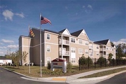
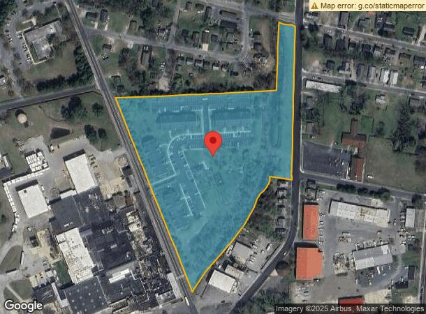
543 West Rd
Salisbury, MD-DE
Mountaire Farms Delmarva Lands
09-003304
PAR C-9.04 AC 543-585 WEST ROAD WESTBROOK COMMONS
Multifamilydwelling
Wicomico
AE
Maryland
24045C0251E
c
2024
9.04 AC
2024
Chesapeake Bay/Salisbury
0102003032
Other Market Areas
27,572 SF
DEMOGRAPHICS near 543 West Rd
1 Mile
3 Mile
5 Mile
2024 Total Population
9,545
50,893
76,651
2029 Population
9,765
51,848
78,163
Pop Growth 2024-2029
+ 2.30%
+ 1.88%
+ 1.97%
Average Age
36
36
38
2024 Total Households
3,772
19,096
29,485
HH Growth 2024-2029
+ 2.41%
+ 1.93%
+ 2.05%
Median Household Inc
$40,718
$54,549
$60,204
Avg Household Size
2.40
2.40
2.40
2024 Avg HH Vehicles
1.00
2.00
2.00
Median Home Value
$154,017
$202,073
$221,079
Median Year Built
1966
1977
1982
Nearby Places
- Restaurants
- Banks
- Shops
- Fitness
- Groceries
PUBLIC TRANSPORTATION
AIRPORT
Salisbury-Ocean City Wicomico Regional
DRIVE
WALK
Distance
Salisbury-Ocean City Wicomico Regional
18 min
8.1 mi
Freight Ports
Port of Baltimore
DRIVE
WALK
Distance
Port of Baltimore
158 min
106.8 mi
Nearby Properties
Address
Land Use
TOTAL SIZE
Lot Size
Zoning
Address
Land Use
TOTAL SIZE
Lot Size
Zoning
1,792 SF
76.32 AC
R20
Address
Land Use
TOTAL SIZE
Lot Size
Zoning
602,336 SF
22.69 AC
H
Address
Land Use
TOTAL SIZE
Lot Size
Zoning
18,951 SF
35.15 AC
R8
Address
Land Use
TOTAL SIZE
Lot Size
Zoning
208,457 SF
3.05 AC
C
Address
Land Use
TOTAL SIZE
Lot Size
Zoning
25,000 SF
23.46 AC
I-2
Address
Land Use
TOTAL SIZE
Lot Size
Zoning
32,100 SF
22.32 AC
LI
Address
Land Use
TOTAL SIZE
Lot Size
Zoning
118,330 SF
1.99 AC
CBD
Address
Land Use
TOTAL SIZE
Lot Size
Zoning
103,992 SF
0.59 AC
CBD
Address
Land Use
TOTAL SIZE
Lot Size
Zoning
160,552 SF
15.48 AC
Address
Land Use
TOTAL SIZE
Lot Size
Zoning
164,178 SF
55.53 AC
R5A
Address
Land Use
TOTAL SIZE
Lot Size
Zoning
20,850 SF
12.08 AC
CU
Address
Land Use
TOTAL SIZE
Lot Size
Zoning
4,093 SF
75.38 AC
R8
Address
Land Use
TOTAL SIZE
Lot Size
Zoning
219,584 SF
23.60 AC
PRD
Address
Land Use
TOTAL SIZE
Lot Size
Zoning
488,450 SF
44.25 AC
GC
Address
Land Use
TOTAL SIZE
Lot Size
Zoning
15,180 SF
15.20 AC
LBIR8
Address
Land Use
TOTAL SIZE
Lot Size
Zoning
14,988 SF
7.51 AC
R8A
Address
Land Use
TOTAL SIZE
Lot Size
Zoning
105,626 SF
53.26 AC
R-8
Address
Land Use
TOTAL SIZE
Lot Size
Zoning
28,365 SF
11.21 AC
R1A
Address
Land Use
TOTAL SIZE
Lot Size
Zoning
5,760 SF
12.09 AC
LBI
Address
Land Use
TOTAL SIZE
Lot Size
Zoning
12,024 SF
12.98 AC
R5A
Address
Land Use
TOTAL SIZE
Lot Size
Zoning
15,531 SF
15.26 AC
GC
Address
Land Use
TOTAL SIZE
Lot Size
Zoning
6,136 SF
52.49 AC
R-10
Address
Land Use
TOTAL SIZE
Lot Size
Zoning
53,810 SF
9.02 AC
PDD
Address
Land Use
TOTAL SIZE
Lot Size
Zoning
3,408 SF
69.67 AC
I
Address
Land Use
TOTAL SIZE
Lot Size
Zoning
19,608 SF
4.99 AC
CU
Address
Land Use
TOTAL SIZE
Lot Size
Zoning
28,761 SF
4.26 AC
CU
Address
Land Use
TOTAL SIZE
Lot Size
Zoning
76,999 SF
7.72 AC
R-8
Address
Land Use
TOTAL SIZE
Lot Size
Zoning
5,824 SF
6.47 AC
Address
Land Use
TOTAL SIZE
Lot Size
Zoning
58,528 SF
15.05 AC
R8
Address
Land Use
TOTAL SIZE
Lot Size
Zoning
1,034 SF
18.79 AC
R-8A
The World's #1 Commercial Real Estate Marketplace
Connect with us
© 2025 CoStar Group
The information above has been obtained from sources believed reliable. While we do not doubt its accuracy we have not verified it and make no guarantee, warranty or representation about it. It is your responsibility to independently confirm its accuracy and completeness. Any projections, opinions, assumptions, or estimates used are for example only and do not represent the current or future performance of the property. The value of this transaction to you depends on tax and other factors which should be evaluated by your tax, financial, and legal advisors. You and your advisors should conduct a careful, independent investigation of the property to determine to your satisfaction the suitability of the property for your needs.