Property Record
544 N Tyndall Pkwy, Panama City, FL 32404
NEARBY LISTINGS FOR SALE OR LEASE
-
-
View all Panama City listings for sale on LoopNet.com
Property Detail
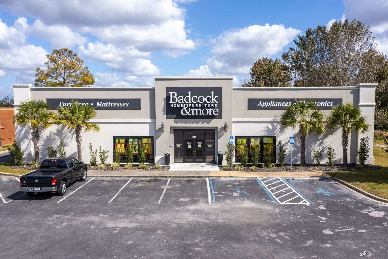
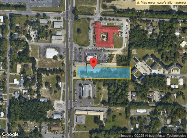
544 N Tyndall Pkwy
Panama City, FL
St And Bay Dev Co Plat
06208-020-010
7 4S 13W -160.2A- 131C2 ST AND BAY DEV CO PLAT BEG INT 0F E R/W HWY 98 & S LINE OF LOT 9 TH N 97.30 E 5 N 37.60 E 618.18 TO E LINE LOT 9 S 135.01 TO SE COR LOT 9 W 621.76 TO POB ORB 1918 P 1480 ORB 2873 P 2317
Storemultistory
Bay
AE
Florida
12005C0362J
9
2023
1.92 AC
2024
Panama City
000803
Other Market Areas
15,000 SF
DEMOGRAPHICS near 544 N Tyndall Pkwy
1 Mile
3 Mile
5 Mile
2024 Total Population
5,105
32,734
52,518
2029 Population
5,531
35,155
56,524
Pop Growth 2024-2029
+ 8.34%
+ 7.40%
+ 7.63%
Average Age
38
39
39
2024 Total Households
1,842
12,211
19,893
HH Growth 2024-2029
+ 8.90%
+ 7.92%
+ 8.18%
Median Household Inc
$46,052
$51,583
$53,005
Avg Household Size
2.60
2.60
2.50
2024 Avg HH Vehicles
2.00
2.00
2.00
Median Home Value
$138,901
$156,337
$175,035
Median Year Built
1984
1984
1985
Nearby Places
- Restaurants
- Banks
- Shops
- Fitness
- Groceries
PUBLIC TRANSPORTATION
AIRPORT
Northwest Florida Beaches International
DRIVE
WALK
Distance
Northwest Florida Beaches International
41 min
26.7 mi
Freight Ports
Port of Panama City
DRIVE
WALK
Distance
Port of Panama City
18 min
9.9 mi
Nearby Properties
Address
Land Use
TOTAL SIZE
Lot Size
Zoning
Address
Land Use
TOTAL SIZE
Lot Size
Zoning
277,246 SF
16 AC
BC15
Address
Land Use
TOTAL SIZE
Lot Size
Zoning
250,600 SF
33.22 AC
PC18
Address
Land Use
TOTAL SIZE
Lot Size
Zoning
226,068 SF
12.80 AC
Address
Land Use
TOTAL SIZE
Lot Size
Zoning
263,872 SF
41.43 AC
PC12
Address
Land Use
TOTAL SIZE
Lot Size
Zoning
415,651 SF
266 AC
BC13
Address
Land Use
TOTAL SIZE
Lot Size
Zoning
424,813 SF
30 AC
Address
Land Use
TOTAL SIZE
Lot Size
Zoning
115,472 SF
9.10 AC
Address
Land Use
TOTAL SIZE
Lot Size
Zoning
143,208 SF
5.45 AC
Address
Land Use
TOTAL SIZE
Lot Size
Zoning
126,234 SF
20.02 AC
PI
Address
Land Use
TOTAL SIZE
Lot Size
Zoning
60,670 SF
15 AC
Address
Land Use
TOTAL SIZE
Lot Size
Zoning
107,778 SF
10 AC
Address
Land Use
TOTAL SIZE
Lot Size
Zoning
56,716 SF
4.32 AC
Address
Land Use
TOTAL SIZE
Lot Size
Zoning
74,914 SF
14.23 AC
BC02
Address
Land Use
TOTAL SIZE
Lot Size
Zoning
181,571 SF
22.29 AC
CLWY04
Address
Land Use
TOTAL SIZE
Lot Size
Zoning
39,628 SF
4.45 AC
CLWY04
Address
Land Use
TOTAL SIZE
Lot Size
Zoning
126,164 SF
9.81 AC
R5
Address
Land Use
TOTAL SIZE
Lot Size
Zoning
548.94 AC
Address
Land Use
TOTAL SIZE
Lot Size
Zoning
46,368 SF
2.30 AC
CLWY23
Address
Land Use
TOTAL SIZE
Lot Size
Zoning
39,456 SF
8.70 AC
Address
Land Use
TOTAL SIZE
Lot Size
Zoning
40,264 SF
2 AC
CLWY04
Address
Land Use
TOTAL SIZE
Lot Size
Zoning
43,110 SF
2.54 AC
PC09
Address
Land Use
TOTAL SIZE
Lot Size
Zoning
55,300 SF
10.91 AC
PC12
Address
Land Use
TOTAL SIZE
Lot Size
Zoning
68,401 SF
30 AC
Address
Land Use
TOTAL SIZE
Lot Size
Zoning
453.24 AC
UND
Address
Land Use
TOTAL SIZE
Lot Size
Zoning
39,298 SF
15.40 AC
PI
Address
Land Use
TOTAL SIZE
Lot Size
Zoning
74,996 SF
10 AC
PI
Address
Land Use
TOTAL SIZE
Lot Size
Zoning
42,456 SF
3.90 AC
CLWY04
Address
Land Use
TOTAL SIZE
Lot Size
Zoning
45,403 SF
2.65 AC
CLWY04
Address
Land Use
TOTAL SIZE
Lot Size
Zoning
43,530 SF
10.70 AC
PC11
Address
Land Use
TOTAL SIZE
Lot Size
Zoning
128,098 SF
0.10 AC
The World's #1 Commercial Real Estate Marketplace
Connect with us
© 2025 CoStar Group
The information above has been obtained from sources believed reliable. While we do not doubt its accuracy we have not verified it and make no guarantee, warranty or representation about it. It is your responsibility to independently confirm its accuracy and completeness. Any projections, opinions, assumptions, or estimates used are for example only and do not represent the current or future performance of the property. The value of this transaction to you depends on tax and other factors which should be evaluated by your tax, financial, and legal advisors. You and your advisors should conduct a careful, independent investigation of the property to determine to your satisfaction the suitability of the property for your needs.