Property Record
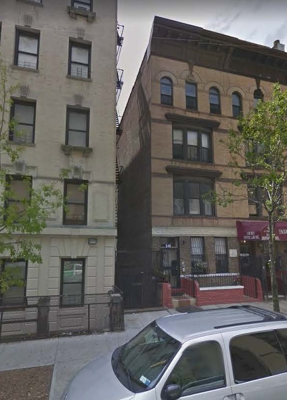
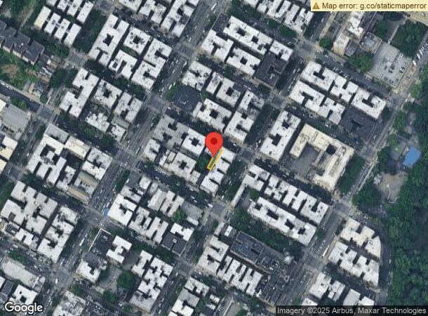
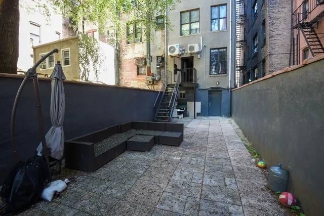
546 W 188Th St, New York, NY 10040
NEARBY LISTINGS FOR SALE OR LEASE
Property Detail
546 W 188Th St
2158-0015
Manhattan
Multifamilydwelling
New York
X
15
3604970081F
0.04 AC
2024
Fort George
2024
New York City
026900
New York-Jersey City-White Plains, NY-NJ
3,720 SF
DEMOGRAPHICS near 546 W 188Th St
1 Mile
3 Mile
5 Mile
2024 Total Population
180,542
1,111,831
2,069,371
2029 Population
167,796
1,043,982
1,930,830
Pop Growth 2024-2029
(7.06%)
(6.10%)
(6.69%)
Average Age
40
39
39
2024 Total Households
67,473
410,711
775,215
HH Growth 2024-2029
(7.43%)
(6.55%)
(7.14%)
Median Household Inc
$47,699
$43,214
$48,886
Avg Household Size
2.50
2.60
2.50
2024 Avg HH Vehicles
.00
.00
1.00
Median Home Value
$561,202
$474,003
$587,328
Median Year Built
1947
1951
1952
Nearby Places
- Restaurants
- Banks
- Shops
- Fitness
- Groceries
PUBLIC TRANSPORTATION
TRANSIT/SUBWAY
191 Street (1 - New York MTA Subway (The Subway))
DRIVE
WALK
Distance
191 Street (1 - New York MTA Subway (The Subway))
1 min
3 min
0.2 mi
181 Street (1 Line) (1 - New York MTA Subway (The Subway))
DRIVE
WALK
Distance
181 Street (1 Line) (1 - New York MTA Subway (The Subway))
1 min
7 min
0.4 mi
181 Street (A Line) (A - New York MTA Subway (The Subway))
DRIVE
WALK
Distance
181 Street (A Line) (A - New York MTA Subway (The Subway))
2 min
12 min
0.7 mi
190 Street (A - New York MTA Subway (The Subway))
DRIVE
WALK
Distance
190 Street (A - New York MTA Subway (The Subway))
2 min
13 min
0.7 mi
Dyckman Street (1 Line) (1 - New York MTA Subway (The Subway))
DRIVE
WALK
Distance
Dyckman Street (1 Line) (1 - New York MTA Subway (The Subway))
2 min
13 min
0.7 mi
COMMUTER RAIL
University Heights Station (Hudson Line - Metro-North Commuter Railroad Company (Metro-North))
DRIVE
WALK
Distance
University Heights Station (Hudson Line - Metro-North Commuter Railroad Company (Metro-North))
5 min
2.0 mi
Morris Heights Station (Hudson Line - Metro-North Commuter Railroad Company (Metro-North))
DRIVE
WALK
Distance
Morris Heights Station (Hudson Line - Metro-North Commuter Railroad Company (Metro-North))
7 min
2.3 mi
AIRPORT
Laguardia
DRIVE
WALK
Distance
Laguardia
19 min
9.4 mi
John F Kennedy International
DRIVE
WALK
Distance
John F Kennedy International
30 min
20.8 mi
Newark Liberty International
DRIVE
WALK
Distance
Newark Liberty International
25 min
20.9 mi
Freight Ports
NY - Red Hook Container Terminal
DRIVE
WALK
Distance
NY - Red Hook Container Terminal
31 min
15.3 mi
SALE & LEASE HISTORY
LISTING DATE
SALE/LEASE

Mar 26, 2019
For Lease
Mar 15, 2020
For Lease
Mar 02, 2022
For Sale
Jun 13, 2017
For Sale
Jul 09, 2019
For Sale
Feb 20, 2020
For Lease
Nearby Properties
Address
Land Use
TOTAL SIZE
Lot Size
Zoning
Address
Land Use
TOTAL SIZE
Lot Size
Zoning
1,290,000 SF
14.56 AC
PARK
Address
Land Use
TOTAL SIZE
Lot Size
Zoning
3,693,539 SF
8.37 AC
R8
Address
Land Use
TOTAL SIZE
Lot Size
Zoning
400,160 SF
10.96 AC
R7-2
Address
Land Use
TOTAL SIZE
Lot Size
Zoning
1,299,700 SF
29.82 AC
R6
Address
Land Use
TOTAL SIZE
Lot Size
Zoning
26.93 AC
R8
Address
Land Use
TOTAL SIZE
Lot Size
Zoning
1,743,584 SF
77.87 AC
R6
Address
Land Use
TOTAL SIZE
Lot Size
Zoning
2,278,432 SF
5.98 AC
R7-2
Address
Land Use
TOTAL SIZE
Lot Size
Zoning
24.08 AC
B2-A
Address
Land Use
TOTAL SIZE
Lot Size
Zoning
1,267,362 SF
1.71 AC
R7-2
Address
Land Use
TOTAL SIZE
Lot Size
Zoning
4.87 AC
R11
Address
Land Use
TOTAL SIZE
Lot Size
Zoning
873,000 SF
9.95 AC
R7-2
Address
Land Use
TOTAL SIZE
Lot Size
Zoning
1,651,267 SF
1.23 AC
R8
Address
Land Use
TOTAL SIZE
Lot Size
Zoning
Address
Land Use
TOTAL SIZE
Lot Size
Zoning
2.61 AC
D5
Address
Land Use
TOTAL SIZE
Lot Size
Zoning
478,842 SF
3.56 AC
C6-1
Address
Land Use
TOTAL SIZE
Lot Size
Zoning
481,172 SF
205.58 AC
PARK
Address
Land Use
TOTAL SIZE
Lot Size
Zoning
1,593,305 SF
9.89 AC
C4-4
Address
Land Use
TOTAL SIZE
Lot Size
Zoning
1,237,424 SF
21.25 AC
R6
Address
Land Use
TOTAL SIZE
Lot Size
Zoning
3.75 AC
Address
Land Use
TOTAL SIZE
Lot Size
Zoning
42.68 AC
P1
Address
Land Use
TOTAL SIZE
Lot Size
Zoning
13.09 AC
C3
Address
Land Use
TOTAL SIZE
Lot Size
Zoning
2 AC
R11
Address
Land Use
TOTAL SIZE
Lot Size
Zoning
100,151 SF
22.13 AC
B2
Address
Land Use
TOTAL SIZE
Lot Size
Zoning
2.55 AC
D5
Address
Land Use
TOTAL SIZE
Lot Size
Zoning
1,390,324 SF
6.87 AC
R8
Address
Land Use
TOTAL SIZE
Lot Size
Zoning
807,327 SF
0.60 AC
R8
Address
Land Use
TOTAL SIZE
Lot Size
Zoning
5.87 AC
R10
Address
Land Use
TOTAL SIZE
Lot Size
Zoning
517,876 SF
1.83 AC
C6-1
Address
Land Use
TOTAL SIZE
Lot Size
Zoning
390,750 SF
265 AC
PARK
Address
Land Use
TOTAL SIZE
Lot Size
Zoning
2,531,670 SF
17.15 AC
R7-2
The World's #1 Commercial Real Estate Marketplace
Connect with us
© 2025 CoStar Group
The information above has been obtained from sources believed reliable. While we do not doubt its accuracy we have not verified it and make no guarantee, warranty or representation about it. It is your responsibility to independently confirm its accuracy and completeness. Any projections, opinions, assumptions, or estimates used are for example only and do not represent the current or future performance of the property. The value of this transaction to you depends on tax and other factors which should be evaluated by your tax, financial, and legal advisors. You and your advisors should conduct a careful, independent investigation of the property to determine to your satisfaction the suitability of the property for your needs.