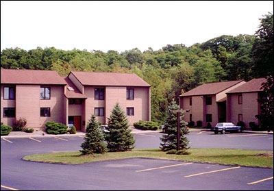
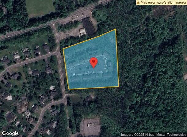
Property Record
5490 Duguid Rd, Fayetteville, NY 13066
NEARBY LISTINGS FOR SALE OR LEASE
-
-
View all Fayetteville listings for sale on LoopNet.com
Property Detail
5490 Duguid Rd
313889-090-000-0001-005-001-0000
Onondaga
Apartment
New York
X
5.001
36067C0261F
5.12 AC
2024
Outer S Onondaga County
2023
Syracuse
015602
Syracuse, NY
3,408 SF
DEMOGRAPHICS near 5490 Duguid Rd
1 Mile
3 Mile
5 Mile
2024 Total Population
2,646
23,640
46,985
2029 Population
2,568
23,051
45,949
Pop Growth 2024-2029
(2.95%)
(2.49%)
(2.20%)
Average Age
43
44
44
2024 Total Households
1,021
9,939
18,984
HH Growth 2024-2029
(3.13%)
(2.71%)
(2.39%)
Median Household Inc
$135,227
$103,579
$102,109
Avg Household Size
2.60
2.30
2.40
2024 Avg HH Vehicles
2.00
2.00
2.00
Median Home Value
$263,457
$254,149
$237,270
Median Year Built
1969
1972
1972
Nearby Places
- Restaurants
- Banks
- Shops
- Fitness
- Groceries
PUBLIC TRANSPORTATION
AIRPORT
Syracuse Hancock International
DRIVE
WALK
Distance
Syracuse Hancock International
29 min
17.8 mi
Freight Ports
Albany, NY Port
DRIVE
WALK
Distance
Albany, NY Port
168 min
135.7 mi
Nearby Properties
Address
Land Use
TOTAL SIZE
Lot Size
Zoning
Address
Land Use
TOTAL SIZE
Lot Size
Zoning
175,424 SF
7.85 AC
RA
Address
Land Use
TOTAL SIZE
Lot Size
Zoning
293,638 SF
58.90 AC
R1
Address
Land Use
TOTAL SIZE
Lot Size
Zoning
219,526 SF
38.98 AC
RA
Address
Land Use
TOTAL SIZE
Lot Size
Zoning
3,909 SF
24.98 AC
RA
Address
Land Use
TOTAL SIZE
Lot Size
Zoning
6.24 AC
RA
Address
Land Use
TOTAL SIZE
Lot Size
Zoning
4,722 SF
35.39 AC
R5
Address
Land Use
TOTAL SIZE
Lot Size
Zoning
115,150 SF
13.32 AC
RS
Address
Land Use
TOTAL SIZE
Lot Size
Zoning
15,240 SF
12.46 AC
R1
Address
Land Use
TOTAL SIZE
Lot Size
Zoning
26,508 SF
4.38 AC
C
Address
Land Use
TOTAL SIZE
Lot Size
Zoning
6,936 SF
13.18 AC
R2
Address
Land Use
TOTAL SIZE
Lot Size
Zoning
78,950 SF
14.52 AC
NS
Address
Land Use
TOTAL SIZE
Lot Size
Zoning
116,748 SF
7.67 AC
R1
Address
Land Use
TOTAL SIZE
Lot Size
Zoning
24.71 AC
RA
Address
Land Use
TOTAL SIZE
Lot Size
Zoning
101,950 SF
7.32 AC
R2
Address
Land Use
TOTAL SIZE
Lot Size
Zoning
128,733 SF
9.76 AC
RS
Address
Land Use
TOTAL SIZE
Lot Size
Zoning
103,965 SF
6.03 AC
R2
Address
Land Use
TOTAL SIZE
Lot Size
Zoning
32,094 SF
1.70 AC
B2
Address
Land Use
TOTAL SIZE
Lot Size
Zoning
401,546 SF
24 AC
C
Address
Land Use
TOTAL SIZE
Lot Size
Zoning
89,462 SF
9.22 AC
CB
Address
Land Use
TOTAL SIZE
Lot Size
Zoning
60,300 SF
3.70 AC
IND
Address
Land Use
TOTAL SIZE
Lot Size
Zoning
5,376 SF
8.91 AC
R2
Address
Land Use
TOTAL SIZE
Lot Size
Zoning
43,620 SF
33.82 AC
R1
Address
Land Use
TOTAL SIZE
Lot Size
Zoning
59,066 SF
3.46 AC
R2
Address
Land Use
TOTAL SIZE
Lot Size
Zoning
13,225 SF
1.48 AC
R2
Address
Land Use
TOTAL SIZE
Lot Size
Zoning
60,621 SF
5.63 AC
C1
Address
Land Use
TOTAL SIZE
Lot Size
Zoning
74,424 SF
35.70 AC
R1
Address
Land Use
TOTAL SIZE
Lot Size
Zoning
52,145 SF
4.36 AC
RS
Address
Land Use
TOTAL SIZE
Lot Size
Zoning
27,864 SF
4.20 AC
CA
Address
Land Use
TOTAL SIZE
Lot Size
Zoning
18,244 SF
5.67 AC
R4
Address
Land Use
TOTAL SIZE
Lot Size
Zoning
9,616 SF
6.40 AC
R5
The World's #1 Commercial Real Estate Marketplace
Connect with us
© 2025 CoStar Group
The information above has been obtained from sources believed reliable. While we do not doubt its accuracy we have not verified it and make no guarantee, warranty or representation about it. It is your responsibility to independently confirm its accuracy and completeness. Any projections, opinions, assumptions, or estimates used are for example only and do not represent the current or future performance of the property. The value of this transaction to you depends on tax and other factors which should be evaluated by your tax, financial, and legal advisors. You and your advisors should conduct a careful, independent investigation of the property to determine to your satisfaction the suitability of the property for your needs.