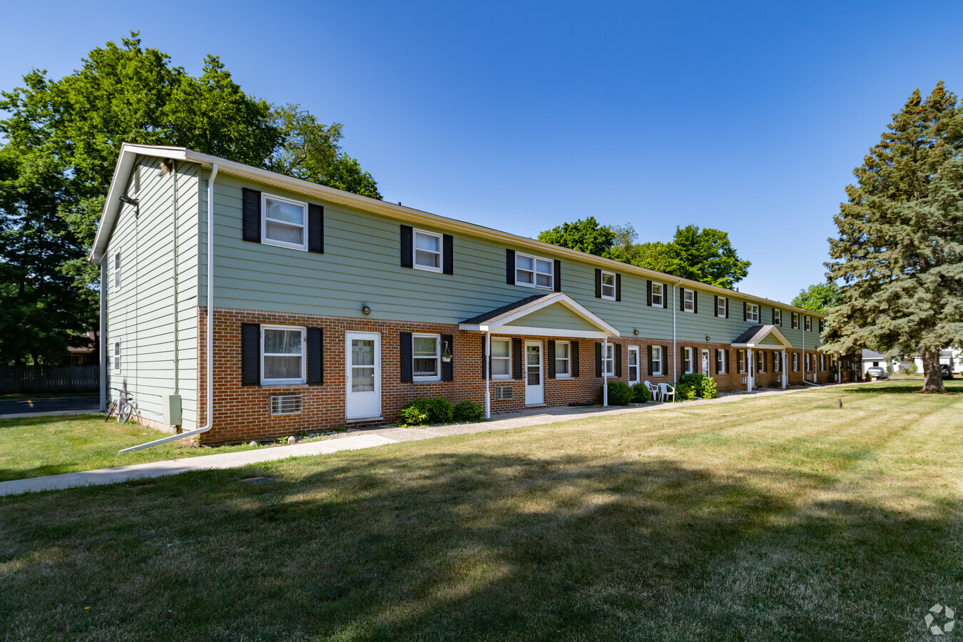
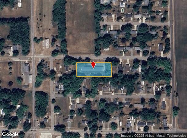
Property Record
550 E Cass St, Schoolcraft, MI 49087

NEARBY LISTINGS FOR SALE OR LEASE
-
-
View all Schoolcraft listings for sale on LoopNet.com
Property Detail
550 E Cass St
Kalamazoo-Portage, MI
Osterhouts Add
14-18-479-080
S 6-15-16-17-18-19 OSTERHOUTS ADDITION TO THE VILLAGE OF SCHOOLCRAFT LOTS 9, 10 11, 12, & 13 BLK 4
Commercialnec
Kalamazoo
X
Michigan
26149C0035D
1,9-13
2023
1 AC
2024
South Kalamazoo County
006102
West Michigan
6,144 SF
DEMOGRAPHICS near 550 E Cass St
1 Mile
3 Mile
5 Mile
2024 Total Population
1,561
3,888
17,114
2029 Population
1,535
3,841
17,060
Pop Growth 2024-2029
(1.67%)
(1.21%)
(0.32%)
Average Age
40
41
40
2024 Total Households
639
1,533
6,658
HH Growth 2024-2029
(1.56%)
(1.24%)
(0.33%)
Median Household Inc
$72,943
$79,096
$79,955
Avg Household Size
2.40
2.50
2.50
2024 Avg HH Vehicles
2.00
2.00
2.00
Median Home Value
$177,892
$246,969
$247,751
Median Year Built
1968
1979
1981
Nearby Places
- Restaurants
- Banks
- Shops
- Fitness
- Groceries
PUBLIC TRANSPORTATION
AIRPORT
Kalamazoo/Battle Creek International
DRIVE
WALK
Distance
Kalamazoo/Battle Creek International
23 min
14.4 mi
Freight Ports
Port of Toledo
DRIVE
WALK
Distance
Port of Toledo
181 min
152.3 mi
SALE & LEASE HISTORY
LISTING DATE
SALE/LEASE

Oct 09, 2019
For Sale
May 17, 2019
For Sale
Jul 14, 2017
For Sale
Apr 03, 2023
For Sale
Nearby Properties
Address
Land Use
TOTAL SIZE
Lot Size
Zoning
Address
Land Use
TOTAL SIZE
Lot Size
Zoning
Address
Land Use
TOTAL SIZE
Lot Size
Zoning
165,750 SF
60 AC
Address
Land Use
TOTAL SIZE
Lot Size
Zoning
19,497 SF
6.38 AC
SCHTWP.ORG
Address
Land Use
TOTAL SIZE
Lot Size
Zoning
137,342 SF
20.98 AC
Address
Land Use
TOTAL SIZE
Lot Size
Zoning
84,760 SF
Address
Land Use
TOTAL SIZE
Lot Size
Zoning
Address
Land Use
TOTAL SIZE
Lot Size
Zoning
49,980 SF
15.73 AC
Address
Land Use
TOTAL SIZE
Lot Size
Zoning
53,450 SF
6 AC
Address
Land Use
TOTAL SIZE
Lot Size
Zoning
2,062 SF
142.41 AC
AG
Address
Land Use
TOTAL SIZE
Lot Size
Zoning
6.10 AC
Address
Land Use
TOTAL SIZE
Lot Size
Zoning
7,972 SF
26.05 AC
AG
Address
Land Use
TOTAL SIZE
Lot Size
Zoning
152,546 SF
10.68 AC
Address
Land Use
TOTAL SIZE
Lot Size
Zoning
62,520 SF
5.95 AC
Address
Land Use
TOTAL SIZE
Lot Size
Zoning
51.47 AC
SCHTWP.ORG
Address
Land Use
TOTAL SIZE
Lot Size
Zoning
1,562 SF
127.04 AC
AG
Address
Land Use
TOTAL SIZE
Lot Size
Zoning
29,750 SF
8.01 AC
Address
Land Use
TOTAL SIZE
Lot Size
Zoning
2,150 SF
135.77 AC
AG
Address
Land Use
TOTAL SIZE
Lot Size
Zoning
4.80 AC
Address
Land Use
TOTAL SIZE
Lot Size
Zoning
41,618 SF
7.30 AC
Address
Land Use
TOTAL SIZE
Lot Size
Zoning
49,196 SF
4.02 AC
Address
Land Use
TOTAL SIZE
Lot Size
Zoning
Address
Land Use
TOTAL SIZE
Lot Size
Zoning
5,760 SF
2.36 AC
Address
Land Use
TOTAL SIZE
Lot Size
Zoning
6,247 SF
4.03 AC
Address
Land Use
TOTAL SIZE
Lot Size
Zoning
1,872 SF
160.88 AC
AG
Address
Land Use
TOTAL SIZE
Lot Size
Zoning
1,456 SF
135.97 AC
AG
Address
Land Use
TOTAL SIZE
Lot Size
Zoning
19,528 SF
4.68 AC
Address
Land Use
TOTAL SIZE
Lot Size
Zoning
205.43 AC
AG
Address
Land Use
TOTAL SIZE
Lot Size
Zoning
2,464 SF
92.10 AC
AG
Address
Land Use
TOTAL SIZE
Lot Size
Zoning
259.20 AC
AG
The World's #1 Commercial Real Estate Marketplace
Connect with us
© 2025 CoStar Group
The information above has been obtained from sources believed reliable. While we do not doubt its accuracy we have not verified it and make no guarantee, warranty or representation about it. It is your responsibility to independently confirm its accuracy and completeness. Any projections, opinions, assumptions, or estimates used are for example only and do not represent the current or future performance of the property. The value of this transaction to you depends on tax and other factors which should be evaluated by your tax, financial, and legal advisors. You and your advisors should conduct a careful, independent investigation of the property to determine to your satisfaction the suitability of the property for your needs.