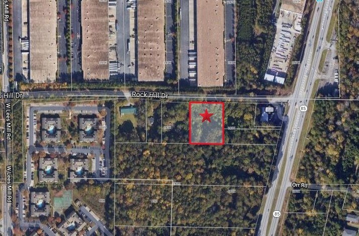
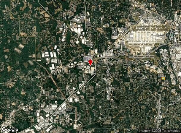
Property Record
550 Rock Hill Dr, Atlanta, GA 30349
NEARBY LISTINGS FOR SALE OR LEASE
Property Detail
550 Rock Hill Dr
13-0086C-00A-005
F C Cargile
Multipleuses
Clayton
X
Georgia
13063C0056F
88
2023
12.77 AC
2023
North Clayton/Airport
010529
Atlanta
180,300 SF
Atlanta-Sandy Springs-Roswell, GA
DEMOGRAPHICS near 550 Rock Hill Dr
1 Mile
3 Mile
5 Mile
2024 Total Population
8,401
69,017
183,631
2029 Population
8,315
68,633
185,176
Pop Growth 2024-2029
(1.02%)
(0.56%)
+ 0.84%
Average Age
33
35
36
2024 Total Households
3,903
26,347
68,549
HH Growth 2024-2029
(0.92%)
(0.61%)
+ 0.91%
Median Household Inc
$37,572
$41,642
$46,428
Avg Household Size
2.10
2.60
2.60
2024 Avg HH Vehicles
1.00
2.00
2.00
Median Home Value
$149,048
$141,046
$158,271
Median Year Built
1988
1980
1980
Nearby Places
- Restaurants
- Banks
- Shops
- Fitness
- Groceries
PUBLIC TRANSPORTATION
AIRPORT
Hartsfield - Jackson Atlanta International
Drive
Walk
Distance
Hartsfield - Jackson Atlanta International
18 min
8.5 mi
Freight Ports
Georgia Ports - Savannah
Drive
Walk
Distance
Georgia Ports - Savannah
280 min
245.7 mi
SALE & LEASE HISTORY
LISTING DATE
SALE/LEASE

Nov 01, 2018
For Sale
Nearby Properties
Address
Land Use
TOTAL SIZE
Lot Size
Zoning
Address
Land Use
TOTAL SIZE
Lot Size
Zoning
2,666 SF
48.11 AC
BP
Address
Land Use
TOTAL SIZE
Lot Size
Zoning
2,666 SF
0.43 AC
Address
Land Use
TOTAL SIZE
Lot Size
Zoning
324,371 SF
2.55 AC
I2
Address
Land Use
TOTAL SIZE
Lot Size
Zoning
410,611 SF
15.51 AC
C2
Address
Land Use
TOTAL SIZE
Lot Size
Zoning
1,325,500 SF
101.81 AC
AG1
Address
Land Use
TOTAL SIZE
Lot Size
Zoning
32,000 SF
8.86 AC
C
Address
Land Use
TOTAL SIZE
Lot Size
Zoning
388,225 SF
32.55 AC
A
Address
Land Use
TOTAL SIZE
Lot Size
Zoning
619,194 SF
49.22 AC
R3
Address
Land Use
TOTAL SIZE
Lot Size
Zoning
1,026,040 SF
72.52 AC
M1
Address
Land Use
TOTAL SIZE
Lot Size
Zoning
613,369 SF
39.53 AC
R3
Address
Land Use
TOTAL SIZE
Lot Size
Zoning
352 SF
32.69 AC
RM
Address
Land Use
TOTAL SIZE
Lot Size
Zoning
71.46 AC
C
Address
Land Use
TOTAL SIZE
Lot Size
Zoning
929,571 SF
65.66 AC
M1
Address
Land Use
TOTAL SIZE
Lot Size
Zoning
358,011 SF
60.44 AC
AG1
Address
Land Use
TOTAL SIZE
Lot Size
Zoning
920,396 SF
62.40 AC
R3
Address
Land Use
TOTAL SIZE
Lot Size
Zoning
679,728 SF
38.08 AC
M2
Address
Land Use
TOTAL SIZE
Lot Size
Zoning
262,427 SF
18.79 AC
MF
Address
Land Use
TOTAL SIZE
Lot Size
Zoning
663,520 SF
62.96 AC
C1
Address
Land Use
TOTAL SIZE
Lot Size
Zoning
855,399 SF
41.79 AC
C2
Address
Land Use
TOTAL SIZE
Lot Size
Zoning
997,011 SF
68.07 AC
M1
Address
Land Use
TOTAL SIZE
Lot Size
Zoning
628,193 SF
56.10 AC
M1
Address
Land Use
TOTAL SIZE
Lot Size
Zoning
612,164 SF
34.83 AC
Address
Land Use
TOTAL SIZE
Lot Size
Zoning
669,152 SF
39.13 AC
M1C
Address
Land Use
TOTAL SIZE
Lot Size
Zoning
773,776 SF
61.42 AC
M1
Address
Land Use
TOTAL SIZE
Lot Size
Zoning
257,723 SF
28.76 AC
C1
Address
Land Use
TOTAL SIZE
Lot Size
Zoning
133,136 SF
4.82 AC
C
Address
Land Use
TOTAL SIZE
Lot Size
Zoning
153,755 SF
5.03 AC
C2
Address
Land Use
TOTAL SIZE
Lot Size
Zoning
768,288 SF
40.65 AC
M1
Address
Land Use
TOTAL SIZE
Lot Size
Zoning
234,763 SF
22.43 AC
OI
Address
Land Use
TOTAL SIZE
Lot Size
Zoning
244,487 SF
21.58 AC
C1
Start a new search to find other properties for sale or lease
Connect with us
© 2024 CoStar Group
The information above has been obtained from sources believed reliable. While we do not doubt its accuracy we have not verified it and make no guarantee, warranty or representation about it. It is your responsibility to independently confirm its accuracy and completeness. Any projections, opinions, assumptions, or estimates used are for example only and do not represent the current or future performance of the property. The value of this transaction to you depends on tax and other factors which should be evaluated by your tax, financial, and legal advisors. You and your advisors should conduct a careful, independent investigation of the property to determine to your satisfaction the suitability of the property for your needs.