Property Record
550 W Valpico Rd, Tracy, CA 95376
NEARBY LISTINGS FOR SALE OR LEASE
Property Detail
550 W Valpico Rd
Tracy/Manteca
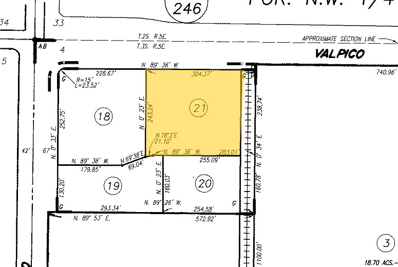
As Shown On That Certain Parcel Map
Stockton/Modesto
San Joaquin
Stockton-Lodi, CA
California
248-020-21
1.67 AC
Servicestationmarket
DEMOGRAPHICS near 550 W Valpico Rd
1 Mile
3 Mile
5 Mile
2024 Total Population
19,693
78,992
102,937
2029 Population
20,689
83,454
108,741
Pop Growth 2024-2029
+ 5.06%
+ 5.65%
+ 5.64%
Average Age
37
37
37
2024 Total Households
5,737
23,489
30,725
HH Growth 2024-2029
+ 5.05%
+ 5.64%
+ 5.64%
Median Household Inc
$129,636
$116,739
$111,270
Avg Household Size
3.30
3.30
3.30
2024 Avg HH Vehicles
3.00
3.00
3.00
Median Home Value
$682,109
$655,661
$644,941
Median Year Built
1997
1995
1994
Nearby Places
- Restaurants
- Banks
- Shops
- Fitness
- Groceries
PUBLIC TRANSPORTATION
COMMUTER RAIL
Tracy (Altamont Corridor Express - Altamont Commuter Express (ACE))
DRIVE
WALK
Distance
Tracy (Altamont Corridor Express - Altamont Commuter Express (ACE))
2 min
20 min
1.1 mi
AIRPORT
Stockton Metro
DRIVE
WALK
Distance
Stockton Metro
29 min
21.2 mi
Freight Ports
Port of Stockton
DRIVE
WALK
Distance
Port of Stockton
32 min
24.5 mi
Nearby Properties
Address
Land Use
TOTAL SIZE
Lot Size
Zoning
Address
Land Use
TOTAL SIZE
Lot Size
Zoning
3.77 AC
Address
Land Use
TOTAL SIZE
Lot Size
Zoning
1,124,201 SF
53.72 AC
Address
Land Use
TOTAL SIZE
Lot Size
Zoning
11.63 AC
Address
Land Use
TOTAL SIZE
Lot Size
Zoning
10.15 AC
PUD1
Address
Land Use
TOTAL SIZE
Lot Size
Zoning
29,442 SF
6.52 AC
Address
Land Use
TOTAL SIZE
Lot Size
Zoning
13,660 SF
18.70 AC
Address
Land Use
TOTAL SIZE
Lot Size
Zoning
263,287 SF
11.99 AC
Address
Land Use
TOTAL SIZE
Lot Size
Zoning
225,000 SF
11.13 AC
M
Address
Land Use
TOTAL SIZE
Lot Size
Zoning
258,520 SF
16.74 AC
Address
Land Use
TOTAL SIZE
Lot Size
Zoning
1,176 SF
22.88 AC
IL
Address
Land Use
TOTAL SIZE
Lot Size
Zoning
143,280 SF
20 AC
Address
Land Use
TOTAL SIZE
Lot Size
Zoning
155,942 SF
11.90 AC
Address
Land Use
TOTAL SIZE
Lot Size
Zoning
64,582 SF
3.10 AC
Address
Land Use
TOTAL SIZE
Lot Size
Zoning
13,440 SF
4.50 AC
Address
Land Use
TOTAL SIZE
Lot Size
Zoning
55,576 SF
2.65 AC
Address
Land Use
TOTAL SIZE
Lot Size
Zoning
6,500 SF
86.80 AC
IG
Address
Land Use
TOTAL SIZE
Lot Size
Zoning
62,246 SF
5.82 AC
NS
Address
Land Use
TOTAL SIZE
Lot Size
Zoning
506,552 SF
22.01 AC
Address
Land Use
TOTAL SIZE
Lot Size
Zoning
225 SF
10.97 AC
Address
Land Use
TOTAL SIZE
Lot Size
Zoning
47,064 SF
2.36 AC
GC
Address
Land Use
TOTAL SIZE
Lot Size
Zoning
158,572 SF
8.83 AC
Address
Land Use
TOTAL SIZE
Lot Size
Zoning
11,375 SF
4.51 AC
Address
Land Use
TOTAL SIZE
Lot Size
Zoning
620,000 SF
32.08 AC
Address
Land Use
TOTAL SIZE
Lot Size
Zoning
52.10 AC
AG40
Address
Land Use
TOTAL SIZE
Lot Size
Zoning
65,715 SF
5.01 AC
Address
Land Use
TOTAL SIZE
Lot Size
Zoning
1,600 SF
3.63 AC
Address
Land Use
TOTAL SIZE
Lot Size
Zoning
60,305 SF
3.22 AC
Address
Land Use
TOTAL SIZE
Lot Size
Zoning
58,551 SF
5.77 AC
Address
Land Use
TOTAL SIZE
Lot Size
Zoning
29.82 AC
AU20
Address
Land Use
TOTAL SIZE
Lot Size
Zoning
9,553 SF
4.99 AC
The World's #1 Commercial Real Estate Marketplace
Connect with us
© 2025 CoStar Group
The information above has been obtained from sources believed reliable. While we do not doubt its accuracy we have not verified it and make no guarantee, warranty or representation about it. It is your responsibility to independently confirm its accuracy and completeness. Any projections, opinions, assumptions, or estimates used are for example only and do not represent the current or future performance of the property. The value of this transaction to you depends on tax and other factors which should be evaluated by your tax, financial, and legal advisors. You and your advisors should conduct a careful, independent investigation of the property to determine to your satisfaction the suitability of the property for your needs.