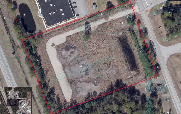
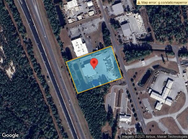
Property Record
5531 Barbados Blvd, Castle Hayne, NC 28429
NEARBY LISTINGS FOR SALE OR LEASE
Property Detail
5531 Barbados Blvd
Wilmington, NC
Island Park Div Lot 1
R01100-008-021-000
LOT 1B ISLAND PARK
Warehouse
New Hanover
X
North Carolina
3720323100K
1b
0
4.02 AC
2023
Castle Hayne
0116082051
Wilmington
15,588 SF
DEMOGRAPHICS near 5531 Barbados Blvd
1 Mile
3 Mile
5 Mile
2024 Total Population
864
8,021
28,224
2029 Population
945
8,828
31,260
Pop Growth 2024-2029
+ 9.38%
+ 10.06%
+ 10.76%
Average Age
41
41
40
2024 Total Households
348
3,238
11,155
HH Growth 2024-2029
+ 9.77%
+ 10.28%
+ 10.93%
Median Household Inc
$63,409
$55,913
$56,987
Avg Household Size
2.30
2.30
2.40
2024 Avg HH Vehicles
2.00
2.00
2.00
Median Home Value
$189,893
$241,452
$239,308
Median Year Built
2002
1997
1995
Nearby Places
- Restaurants
- Banks
- Shops
- Fitness
- Groceries
PUBLIC TRANSPORTATION
AIRPORT
Wilmington International
DRIVE
WALK
Distance
Wilmington International
21 min
8.8 mi
Freight Ports
Port of Wilmington
DRIVE
WALK
Distance
Port of Wilmington
29 min
16.4 mi
Nearby Properties
Address
Land Use
TOTAL SIZE
Lot Size
Zoning
Address
Land Use
TOTAL SIZE
Lot Size
Zoning
82,491 SF
100.98 AC
O&I,OFFICE
Address
Land Use
TOTAL SIZE
Lot Size
Zoning
78,771 SF
59.13 AC
R-15,RESID
Address
Land Use
TOTAL SIZE
Lot Size
Zoning
2,104 SF
205.23 AC
I-2,INDUST
Address
Land Use
TOTAL SIZE
Lot Size
Zoning
137,634 SF
21.29 AC
R-10,RESID
Address
Land Use
TOTAL SIZE
Lot Size
Zoning
21,177 SF
11.10 AC
PD,PLANNED
Address
Land Use
TOTAL SIZE
Lot Size
Zoning
58,628 SF
1.52 AC
O&I,OFFICE
Address
Land Use
TOTAL SIZE
Lot Size
Zoning
214,240 SF
18.47 AC
PD,PLANNED
Address
Land Use
TOTAL SIZE
Lot Size
Zoning
48,904 SF
79.31 AC
R-15,RESID
Address
Land Use
TOTAL SIZE
Lot Size
Zoning
1,873.88 AC
I-2,INDUST
Address
Land Use
TOTAL SIZE
Lot Size
Zoning
66,444 SF
6.48 AC
PD,PLANNED
Address
Land Use
TOTAL SIZE
Lot Size
Zoning
84,864 SF
8.25 AC
PD,PLANNED
Address
Land Use
TOTAL SIZE
Lot Size
Zoning
79,072 SF
8.61 AC
PD,PLANNED
Address
Land Use
TOTAL SIZE
Lot Size
Zoning
936 SF
29.45 AC
O&I,OFFICE
Address
Land Use
TOTAL SIZE
Lot Size
Zoning
7,200 SF
I-2,INDUST
Address
Land Use
TOTAL SIZE
Lot Size
Zoning
3,150 SF
10.39 AC
B-2,BUSINE
Address
Land Use
TOTAL SIZE
Lot Size
Zoning
18,870 SF
3.23 AC
O&I,OFFICE
Address
Land Use
TOTAL SIZE
Lot Size
Zoning
8,640 SF
4.55 AC
PD,PLANNED
Address
Land Use
TOTAL SIZE
Lot Size
Zoning
30,000 SF
8.70 AC
I-2,INDUST
Address
Land Use
TOTAL SIZE
Lot Size
Zoning
32,310 SF
9.51 AC
I-1,INDUST
Address
Land Use
TOTAL SIZE
Lot Size
Zoning
45,129 SF
7.67 AC
PD,PLANNED
Address
Land Use
TOTAL SIZE
Lot Size
Zoning
11,740 SF
2.77 AC
PD,PLANNED
Address
Land Use
TOTAL SIZE
Lot Size
Zoning
61,380 SF
5.70 AC
PD,PLANNED
Address
Land Use
TOTAL SIZE
Lot Size
Zoning
62,539 SF
6.29 AC
PD,PLANNED
Address
Land Use
TOTAL SIZE
Lot Size
Zoning
15,012 SF
9.67 AC
PD,PLANNED
Address
Land Use
TOTAL SIZE
Lot Size
Zoning
11,941 SF
1.87 AC
B-2,BUSINE
Address
Land Use
TOTAL SIZE
Lot Size
Zoning
31,680 SF
46.84 AC
I-2,INDUST
Address
Land Use
TOTAL SIZE
Lot Size
Zoning
7,144 SF
3.10 AC
PD,PLANNED
Address
Land Use
TOTAL SIZE
Lot Size
Zoning
37,886 SF
4.26 AC
B-2,BUSINE
Address
Land Use
TOTAL SIZE
Lot Size
Zoning
5,371 SF
41.98 AC
RA,RURAL A
Address
Land Use
TOTAL SIZE
Lot Size
Zoning
20,000 SF
3.35 AC
I-1,INDUST
The World's #1 Commercial Real Estate Marketplace
Connect with us
© 2025 CoStar Group
The information above has been obtained from sources believed reliable. While we do not doubt its accuracy we have not verified it and make no guarantee, warranty or representation about it. It is your responsibility to independently confirm its accuracy and completeness. Any projections, opinions, assumptions, or estimates used are for example only and do not represent the current or future performance of the property. The value of this transaction to you depends on tax and other factors which should be evaluated by your tax, financial, and legal advisors. You and your advisors should conduct a careful, independent investigation of the property to determine to your satisfaction the suitability of the property for your needs.