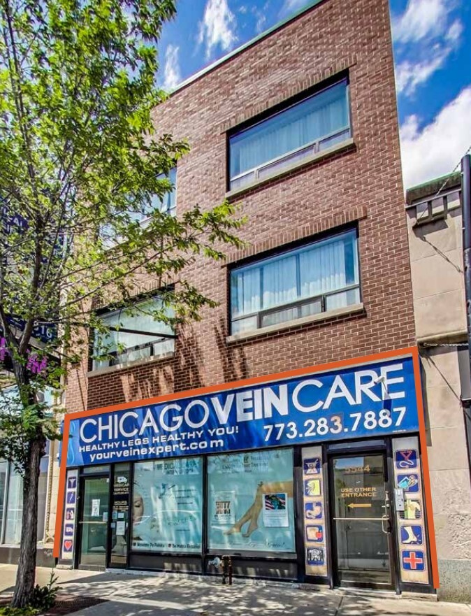
Property Record
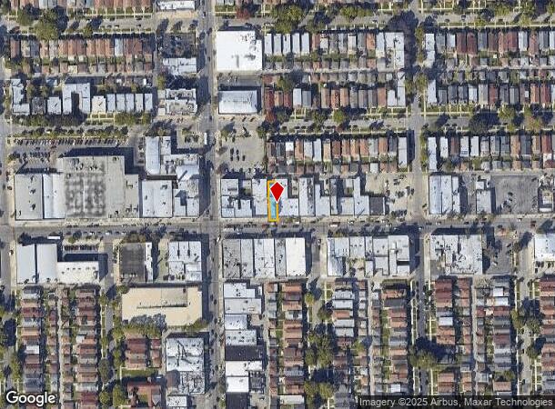
5544 W Belmont Ave, Chicago, IL 60641

NEARBY LISTINGS FOR SALE OR LEASE
Property Detail
5544 W Belmont Ave
Chicago-Naperville-Elgin, IL-IN-WI
Rtins Sub
13-21-327-019-0000
(SUBDIVISION)OF LT 2 EX W100FT OF BLK 2 IN HIELD & MA RTINS SUB BLKS 5&6 IN SUB LTS D-F IN PARTITION OF WH SW SEC 21-40-13
Miscresidentialimprovement
Cook
X
Illinois
17031C0385J
2,d
2022
0.07 AC
2024
Northwest City
151100
Chicago
5,510 SF
DEMOGRAPHICS near 5544 W Belmont Ave
1 Mile
3 Mile
5 Mile
2024 Total Population
51,930
366,421
874,644
2029 Population
48,104
342,633
827,969
Pop Growth 2024-2029
(7.37%)
(6.49%)
(5.34%)
Average Age
39
39
39
2024 Total Households
16,445
130,583
338,208
HH Growth 2024-2029
(7.81%)
(6.79%)
(5.57%)
Median Household Inc
$72,126
$70,274
$75,748
Avg Household Size
3.00
2.70
2.50
2024 Avg HH Vehicles
2.00
2.00
1.00
Median Home Value
$314,000
$319,945
$358,319
Median Year Built
1946
1947
1948
Nearby Places
- Restaurants
- Banks
- Shops
- Fitness
- Groceries
PUBLIC TRANSPORTATION
COMMUTER RAIL
Hanson Park Station (Milwaukee District West Line - Northeast Illinois Regional Commuter Railroad (Metra), North Central Service - Northeast Illinois Regional Commuter Railroad (Metra))
DRIVE
WALK
Distance
Hanson Park Station (Milwaukee District West Line - Northeast Illinois Regional Commuter Railroad (Metra), North Central Service - Northeast Illinois Regional Commuter Railroad (Metra))
3 min
1.6 mi
Grayland Station (Milwaukee District North Line - Northeast Illinois Regional Commuter Railroad (Metra))
DRIVE
WALK
Distance
Grayland Station (Milwaukee District North Line - Northeast Illinois Regional Commuter Railroad (Metra))
4 min
2.0 mi
AIRPORT
Chicago O'Hare International
DRIVE
WALK
Distance
Chicago O'Hare International
17 min
10.2 mi
Chicago Midway International
DRIVE
WALK
Distance
Chicago Midway International
21 min
11.6 mi
Freight Ports
Port Milwaukee
DRIVE
WALK
Distance
Port Milwaukee
98 min
80.1 mi
SALE & LEASE HISTORY
LISTING DATE
SALE/LEASE

Nov 15, 2022
For Lease
Nov 08, 2017
For Sale
Nov 08, 2017
For Sale
Nov 08, 2017
For Sale
Nov 07, 2017
For Sale
Mar 24, 2023
For Sale
Jun 15, 2021
For Sale
Nearby Properties
Address
Land Use
TOTAL SIZE
Lot Size
Zoning
Address
Land Use
TOTAL SIZE
Lot Size
Zoning
192,365 SF
21.34 AC
PD 127
Address
Land Use
TOTAL SIZE
Lot Size
Zoning
237,832 SF
14.04 AC
PD 418
Address
Land Use
TOTAL SIZE
Lot Size
Zoning
897,723 SF
23.04 AC
PMD 15
Address
Land Use
TOTAL SIZE
Lot Size
Zoning
13.33 AC
PD 127
Address
Land Use
TOTAL SIZE
Lot Size
Zoning
9.90 AC
Address
Land Use
TOTAL SIZE
Lot Size
Zoning
1.04 AC
PD 130
Address
Land Use
TOTAL SIZE
Lot Size
Zoning
382,635 SF
5.90 AC
M1-1
Address
Land Use
TOTAL SIZE
Lot Size
Zoning
6.31 AC
PD 1013
Address
Land Use
TOTAL SIZE
Lot Size
Zoning
277,819 SF
10.58 AC
PD 127
Address
Land Use
TOTAL SIZE
Lot Size
Zoning
194,582 SF
12.68 AC
PD 699
Address
Land Use
TOTAL SIZE
Lot Size
Zoning
15,600 SF
0.77 AC
M1-1
Address
Land Use
TOTAL SIZE
Lot Size
Zoning
3.33 AC
PD 1013
Address
Land Use
TOTAL SIZE
Lot Size
Zoning
100,900 SF
4.85 AC
PD 1415
Address
Land Use
TOTAL SIZE
Lot Size
Zoning
126,955 SF
13.70 AC
PD 541
Address
Land Use
TOTAL SIZE
Lot Size
Zoning
78,410 SF
4.87 AC
PD 171
Address
Land Use
TOTAL SIZE
Lot Size
Zoning
109,176 SF
6.54 AC
B1-1
Address
Land Use
TOTAL SIZE
Lot Size
Zoning
389,400 SF
28.83 AC
PMD 9
Address
Land Use
TOTAL SIZE
Lot Size
Zoning
179,150 SF
15.56 AC
PD 903
Address
Land Use
TOTAL SIZE
Lot Size
Zoning
138,042 SF
11.74 AC
PD 127
Address
Land Use
TOTAL SIZE
Lot Size
Zoning
226,155 SF
5.86 AC
PMD 9
Address
Land Use
TOTAL SIZE
Lot Size
Zoning
71,133 SF
7.28 AC
PD 441
Address
Land Use
TOTAL SIZE
Lot Size
Zoning
0.43 AC
RS-2
Address
Land Use
TOTAL SIZE
Lot Size
Zoning
113,877 SF
9.10 AC
PD 578
Address
Land Use
TOTAL SIZE
Lot Size
Zoning
141,095 SF
9.15 AC
PD 127
Address
Land Use
TOTAL SIZE
Lot Size
Zoning
130,310 SF
0.82 AC
PD 1371
Address
Land Use
TOTAL SIZE
Lot Size
Zoning
Address
Land Use
TOTAL SIZE
Lot Size
Zoning
134,209 SF
8.15 AC
PD 912
Address
Land Use
TOTAL SIZE
Lot Size
Zoning
65,800 SF
0.90 AC
PD 1376
Address
Land Use
TOTAL SIZE
Lot Size
Zoning
306,872 SF
3.61 AC
PD 617
Address
Land Use
TOTAL SIZE
Lot Size
Zoning
36,800 SF
1.01 AC
C2-1
The World's #1 Commercial Real Estate Marketplace
Connect with us
© 2025 CoStar Group
The information above has been obtained from sources believed reliable. While we do not doubt its accuracy we have not verified it and make no guarantee, warranty or representation about it. It is your responsibility to independently confirm its accuracy and completeness. Any projections, opinions, assumptions, or estimates used are for example only and do not represent the current or future performance of the property. The value of this transaction to you depends on tax and other factors which should be evaluated by your tax, financial, and legal advisors. You and your advisors should conduct a careful, independent investigation of the property to determine to your satisfaction the suitability of the property for your needs.