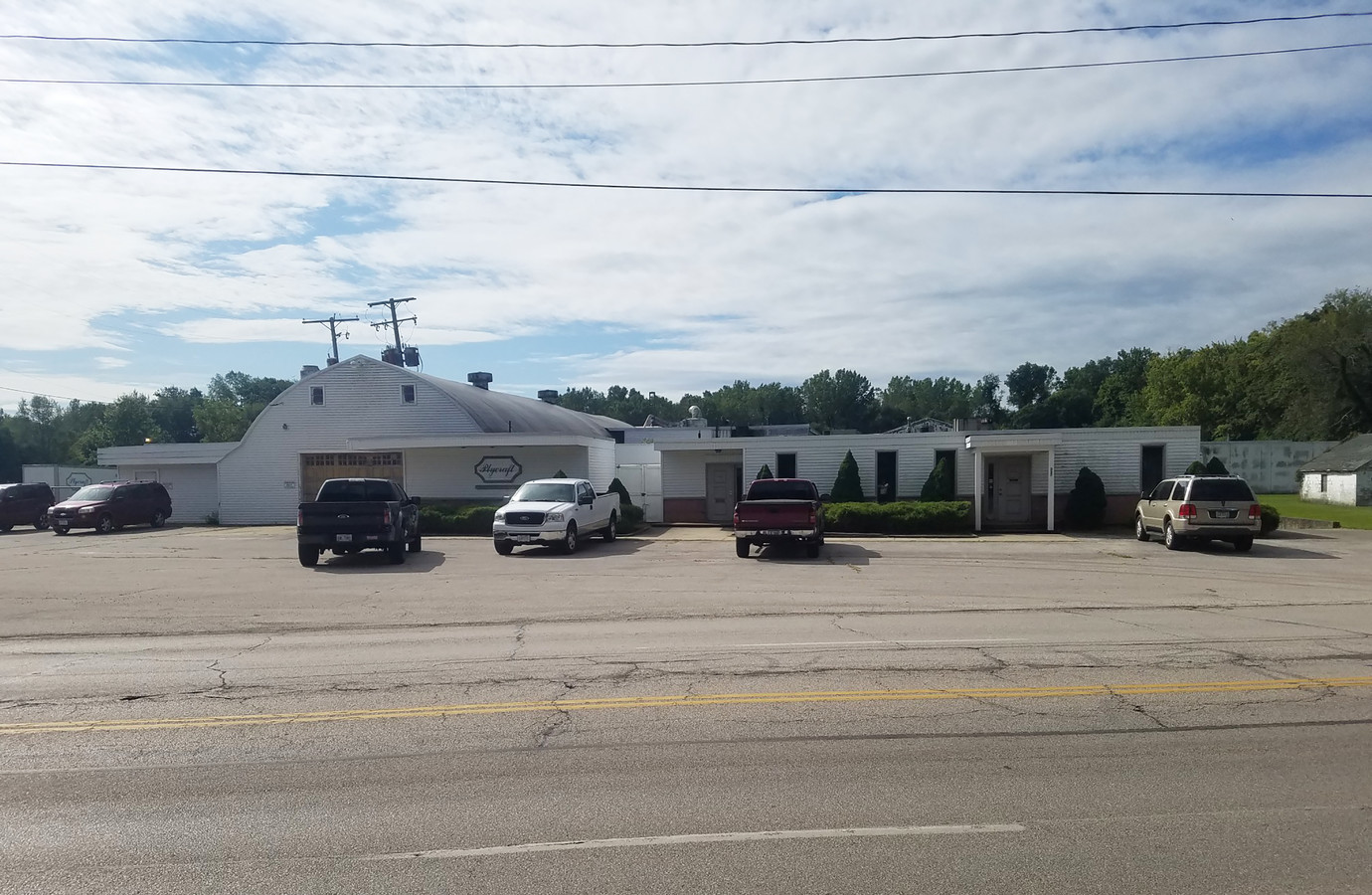
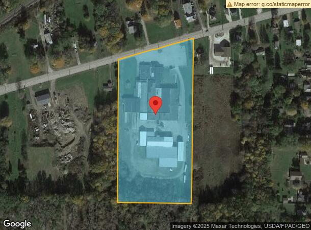
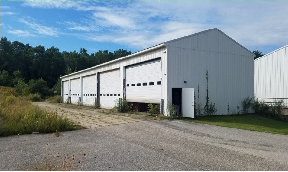
Property Record
577 W Main Rd, Conneaut, OH 44030
Current Lease Availabilities
NEARBY LISTINGS FOR SALE OR LEASE
-
-
View all Conneaut listings for lease on LoopNet.com
Property Detail
577 W Main Rd
123240006900
57 M & S
Lightindustrial
Ashtabula
X
Ohio
42049C0300D
57
2023
8.37 AC
2023
Ashtabula County
000103
Cleveland
88,891 SF
Ashtabula, OH
DEMOGRAPHICS near 577 W Main Rd
1 Mile
3 Mile
5 Mile
2024 Total Population
1,126
6,493
17,643
2029 Population
1,115
6,472
17,623
Pop Growth 2024-2029
(0.98%)
(0.32%)
(0.11%)
Average Age
45
44
43
2024 Total Households
482
2,857
6,740
HH Growth 2024-2029
(1.04%)
(0.28%)
(0.19%)
Median Household Inc
$65,357
$56,439
$47,849
Avg Household Size
2.10
2.10
2.20
2024 Avg HH Vehicles
2.00
2.00
2.00
Median Home Value
$132,738
$130,124
$115,257
Median Year Built
1960
1958
1954
Nearby Places
- Restaurants
- Banks
- Shops
- Fitness
- Groceries
PUBLIC TRANSPORTATION
AIRPORT
Erie International/Tom Ridge Field
DRIVE
WALK
Distance
Erie International/Tom Ridge Field
42 min
26.8 mi
Freight Ports
Port of Toledo
DRIVE
WALK
Distance
Port of Toledo
217 min
182.8 mi
Nearby Properties
Address
Land Use
TOTAL SIZE
Lot Size
Zoning
Address
Land Use
TOTAL SIZE
Lot Size
Zoning
Address
Land Use
TOTAL SIZE
Lot Size
Zoning
78,100 SF
7.28 AC
Address
Land Use
TOTAL SIZE
Lot Size
Zoning
Address
Land Use
TOTAL SIZE
Lot Size
Zoning
0.09 AC
Address
Land Use
TOTAL SIZE
Lot Size
Zoning
254,037 SF
16.47 AC
Address
Land Use
TOTAL SIZE
Lot Size
Zoning
57,714 SF
8.65 AC
Address
Land Use
TOTAL SIZE
Lot Size
Zoning
202,939 SF
36.27 AC
Address
Land Use
TOTAL SIZE
Lot Size
Zoning
289,019 SF
34.01 AC
Address
Land Use
TOTAL SIZE
Lot Size
Zoning
213,400 SF
10.02 AC
Address
Land Use
TOTAL SIZE
Lot Size
Zoning
102,157 SF
10 AC
Address
Land Use
TOTAL SIZE
Lot Size
Zoning
75,074 SF
5.61 AC
Address
Land Use
TOTAL SIZE
Lot Size
Zoning
Address
Land Use
TOTAL SIZE
Lot Size
Zoning
98,857 SF
18.62 AC
Address
Land Use
TOTAL SIZE
Lot Size
Zoning
16,103 SF
12.65 AC
Address
Land Use
TOTAL SIZE
Lot Size
Zoning
110,576 SF
17.91 AC
Address
Land Use
TOTAL SIZE
Lot Size
Zoning
31,756 SF
4.34 AC
Address
Land Use
TOTAL SIZE
Lot Size
Zoning
24,142 SF
11.46 AC
Address
Land Use
TOTAL SIZE
Lot Size
Zoning
53,569 SF
8.83 AC
Address
Land Use
TOTAL SIZE
Lot Size
Zoning
6,136 SF
70.55 AC
Address
Land Use
TOTAL SIZE
Lot Size
Zoning
16,872 SF
45.37 AC
Address
Land Use
TOTAL SIZE
Lot Size
Zoning
1,057 SF
56.20 AC
Address
Land Use
TOTAL SIZE
Lot Size
Zoning
83,400 SF
12.13 AC
Address
Land Use
TOTAL SIZE
Lot Size
Zoning
160,414 SF
10.69 AC
Address
Land Use
TOTAL SIZE
Lot Size
Zoning
19,260 SF
0.21 AC
Address
Land Use
TOTAL SIZE
Lot Size
Zoning
6,487 SF
10.40 AC
Address
Land Use
TOTAL SIZE
Lot Size
Zoning
14,425 SF
15.94 AC
Address
Land Use
TOTAL SIZE
Lot Size
Zoning
16,960 SF
8.58 AC
Address
Land Use
TOTAL SIZE
Lot Size
Zoning
165,814 SF
10.55 AC
Address
Land Use
TOTAL SIZE
Lot Size
Zoning
4,736 SF
9.06 AC
Address
Land Use
TOTAL SIZE
Lot Size
Zoning
52,148 SF
13.52 AC
The World's #1 Commercial Real Estate Marketplace
Connect with us
© 2025 CoStar Group
The information above has been obtained from sources believed reliable. While we do not doubt its accuracy we have not verified it and make no guarantee, warranty or representation about it. It is your responsibility to independently confirm its accuracy and completeness. Any projections, opinions, assumptions, or estimates used are for example only and do not represent the current or future performance of the property. The value of this transaction to you depends on tax and other factors which should be evaluated by your tax, financial, and legal advisors. You and your advisors should conduct a careful, independent investigation of the property to determine to your satisfaction the suitability of the property for your needs.