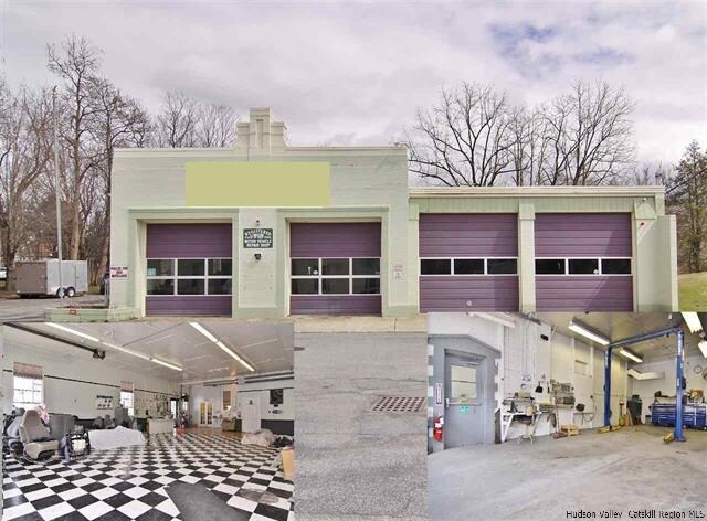
Property Record
56 Main St, Esopus, NY 12429


NEARBY LISTINGS FOR SALE OR LEASE
Property Detail
56 Main St
2200-072.009-0004-018.000-0000
Ulster
Autorepair
New York
X
18.000
36027C0254E
1 AC
2025
Newburgh/Kingston
2024
Other Market Areas
952600
Kingston, NY
3,876 SF
DEMOGRAPHICS near 56 Main St
1 Mile
3 Mile
5 Mile
2024 Total Population
76
5,638
19,017
2029 Population
74
5,597
18,890
Pop Growth 2024-2029
(2.63%)
(0.73%)
(0.67%)
Average Age
43
45
45
2024 Total Households
22
2,050
7,547
HH Growth 2024-2029
(4.55%)
(0.88%)
(0.74%)
Median Household Inc
$143,749
$93,095
$84,286
Avg Household Size
2.30
2.30
2.30
2024 Avg HH Vehicles
2.00
2.00
2.00
Median Home Value
$337,500
$314,333
$285,595
Median Year Built
1961
1966
1968
Nearby Places
Map Layers
Map Styles
 Street
 Aerial
- Restaurants
- Banks
- Shops
- Fitness
- Groceries
PUBLIC TRANSPORTATION
AIRPORT
New York Stewart International
DRIVE
WALK
Distance
New York Stewart International
41 min
29.8 mi
Freight Ports
Albany, NY Port
DRIVE
WALK
Distance
Albany, NY Port
77 min
61.0 mi
SALE & LEASE HISTORY
LISTING DATE
SALE/LEASE

Sep 24, 2016
For Sale
Aug 07, 2018
For Sale
Apr 25, 2019
For Lease
Apr 19, 2017
For Sale
Nearby Properties
Address
Land Use
TOTAL SIZE
Lot Size
Zoning
Address
Land Use
TOTAL SIZE
Lot Size
Zoning
123,500 SF
407 AC
RF1
Address
Land Use
TOTAL SIZE
Lot Size
Zoning
23,195 SF
142.20 AC
RF1
Address
Land Use
TOTAL SIZE
Lot Size
Zoning
53,841 SF
195.70 AC
WF
Address
Land Use
TOTAL SIZE
Lot Size
Zoning
64,597 SF
200.40 AC
R40
Address
Land Use
TOTAL SIZE
Lot Size
Zoning
32,934 SF
3 AC
R40
Address
Land Use
TOTAL SIZE
Lot Size
Zoning
14,786 SF
24.80 AC
R40
Address
Land Use
TOTAL SIZE
Lot Size
Zoning
24,956 SF
100 AC
WF
Address
Land Use
TOTAL SIZE
Lot Size
Zoning
80,688 SF
86.88 AC
WF
Address
Land Use
TOTAL SIZE
Lot Size
Zoning
3,696 SF
13.70 AC
R40
Address
Land Use
TOTAL SIZE
Lot Size
Zoning
9,325 SF
4 AC
GC
Address
Land Use
TOTAL SIZE
Lot Size
Zoning
130.56 AC
RF1
Address
Land Use
TOTAL SIZE
Lot Size
Zoning
25,526 SF
5.60 AC
R40
Address
Land Use
TOTAL SIZE
Lot Size
Zoning
27,597 SF
8.76 AC
R40
Address
Land Use
TOTAL SIZE
Lot Size
Zoning
48,075 SF
3.30 AC
WF
Address
Land Use
TOTAL SIZE
Lot Size
Zoning
10,352 SF
9 AC
R40
Address
Land Use
TOTAL SIZE
Lot Size
Zoning
10.70 AC
WF
Address
Land Use
TOTAL SIZE
Lot Size
Zoning
218.60 AC
R12
Address
Land Use
TOTAL SIZE
Lot Size
Zoning
7,122 SF
27.30 AC
R40
Address
Land Use
TOTAL SIZE
Lot Size
Zoning
6,016 SF
12.50 AC
R40
Address
Land Use
TOTAL SIZE
Lot Size
Zoning
1,385 SF
82.82 AC
RF1
Address
Land Use
TOTAL SIZE
Lot Size
Zoning
19,289 SF
5 AC
WF
Address
Land Use
TOTAL SIZE
Lot Size
Zoning
207.67 AC
WF
Address
Land Use
TOTAL SIZE
Lot Size
Zoning
11,903 SF
91.10 AC
WF
Address
Land Use
TOTAL SIZE
Lot Size
Zoning
13,212 SF
26.70 AC
R40
Address
Land Use
TOTAL SIZE
Lot Size
Zoning
27,984 SF
10.34 AC
N
Address
Land Use
TOTAL SIZE
Lot Size
Zoning
5,212 SF
1.70 AC
R40
Address
Land Use
TOTAL SIZE
Lot Size
Zoning
66.30 AC
R40
Address
Land Use
TOTAL SIZE
Lot Size
Zoning
1,056 SF
42.10 AC
R40
Address
Land Use
TOTAL SIZE
Lot Size
Zoning
52.30 AC
RF1
Address
Land Use
TOTAL SIZE
Lot Size
Zoning
117 AC
02 - SINGL
The World's #1 Commercial Real Estate Marketplace
Connect with us
© 2025 CoStar Group
The information above has been obtained from sources believed reliable. While we do not doubt its accuracy we have not verified it and make no guarantee, warranty or representation about it. It is your responsibility to independently confirm its accuracy and completeness. Any projections, opinions, assumptions, or estimates used are for example only and do not represent the current or future performance of the property. The value of this transaction to you depends on tax and other factors which should be evaluated by your tax, financial, and legal advisors. You and your advisors should conduct a careful, independent investigation of the property to determine to your satisfaction the suitability of the property for your needs.